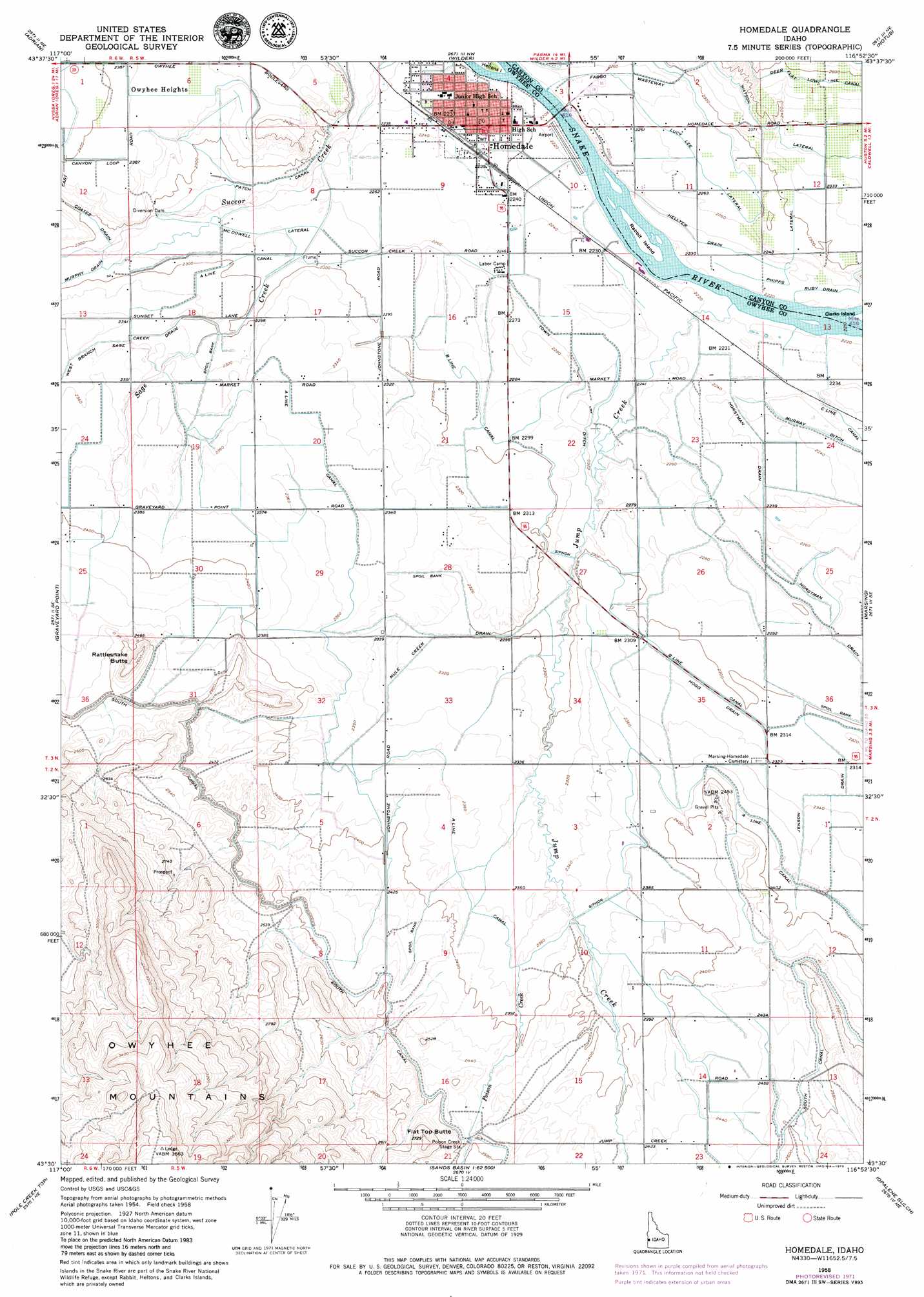
Homedale Topo Map Idaho
To zoom in, hover over the map of Homedale
USGS Topo Quad 43116e8 - 1:24,000 scale
| Topo Map Name: | Homedale |
| USGS Topo Quad ID: | 43116e8 |
| Print Size: | ca. 21 1/4" wide x 27" high |
| Southeast Coordinates: | 43.5° N latitude / 116.875° W longitude |
| Map Center Coordinates: | 43.5625° N latitude / 116.9375° W longitude |
| U.S. State: | ID |
| Filename: | o43116e8.jpg |
| Download Map JPG Image: | Homedale topo map 1:24,000 scale |
| Map Type: | Topographic |
| Topo Series: | 7.5´ |
| Map Scale: | 1:24,000 |
| Source of Map Images: | United States Geological Survey (USGS) |
| Alternate Map Versions: |
Homedale ID 1958, updated 1960 Download PDF Buy paper map Homedale ID 1958, updated 1972 Download PDF Buy paper map Homedale ID 2010 Download PDF Buy paper map Homedale ID 2013 Download PDF Buy paper map |
1:24,000 Topo Quads surrounding Homedale
Mitchell Butte |
Owyhee |
Parma |
Parma Se |
Sand Hollow |
Owyhee Dam |
Adrian |
Wilder |
Notus |
Caldwell |
Owyhee Ridge |
Graveyard Point |
Homedale |
Marsing |
Lake Lowell |
Three Fingers Rock |
Pole Creek Top |
Jump Creek Canyon |
Opalene Gulch |
Givens Hot Springs |
Bannock Ridge |
Rockville |
Piute Butte |
Soldier Cap |
Wilson Peak |
> Back to 43116e1 at 1:100,000 scale
> Back to 43116a1 at 1:250,000 scale
> Back to U.S. Topo Maps home
Homedale topo map: Gazetteer
Homedale: Airports
Homedale Municipal Airport elevation 677m 2221′Homedale: Canals
A Line Canal elevation 722m 2368′B Line Canal elevation 702m 2303′
Fargo Wasteway elevation 684m 2244′
Hellyer Drain elevation 680m 2230′
Horstman Drain elevation 683m 2240′
Lucy Lee Lateral elevation 692m 2270′
McDowell Lateral elevation 696m 2283′
Murphy Drain elevation 700m 2296′
Murray Ditch elevation 688m 2257′
Patch Canal elevation 695m 2280′
Phipps Lateral elevation 698m 2290′
Ruby Drain elevation 682m 2237′
South Canal elevation 760m 2493′
Town Ditch elevation 687m 2253′
Watson Lateral elevation 722m 2368′
Homedale: Islands
Rabbit Island elevation 678m 2224′Homedale: Populated Places
Homedale elevation 680m 2230′Owyhee Heights elevation 728m 2388′
Homedale: Streams
Jenson Drain elevation 712m 2335′Jump Creek elevation 677m 2221′
Poison Creek elevation 721m 2365′
Sage Creek elevation 683m 2240′
Homedale: Summits
Flat Top Butte elevation 831m 2726′Rattlesnake Butte elevation 803m 2634′
Homedale digital topo map on disk
Buy this Homedale topo map showing relief, roads, GPS coordinates and other geographical features, as a high-resolution digital map file on DVD: