Robie Creek Topo Map Idaho
To zoom in, hover over the map of Robie Creek
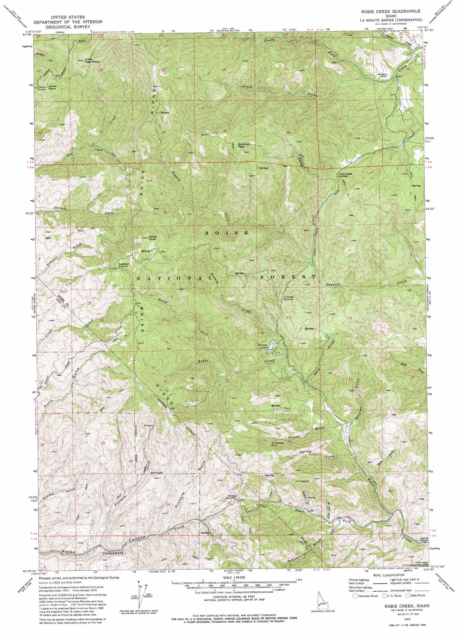
USGS Topo Quad 43116f1 - 1:24,000 scale
| Topo Map Name: | Robie Creek |
| USGS Topo Quad ID: | 43116f1 |
| Print Size: | ca. 21 1/4" wide x 27" high |
| Southeast Coordinates: | 43.625° N latitude / 116° W longitude |
| Map Center Coordinates: | 43.6875° N latitude / 116.0625° W longitude |
| U.S. State: | ID |
| Filename: | o43116f1.jpg |
| Download Map JPG Image: | Robie Creek topo map 1:24,000 scale |
| Map Type: | Topographic |
| Topo Series: | 7.5´ |
| Map Scale: | 1:24,000 |
| Source of Map Images: | United States Geological Survey (USGS) |
| Alternate Map Versions: |
Robie Creek ID 1949, updated 1986 Download PDF Buy paper map Robie Creek ID 1972, updated 1975 Download PDF Buy paper map Robie Creek ID 1972, updated 1985 Download PDF Buy paper map Robie Creek ID 2011 Download PDF Buy paper map Robie Creek ID 2013 Download PDF Buy paper map |
| FStopo: | US Forest Service topo Robie Creek is available: Download FStopo PDF Download FStopo TIF |
1:24,000 Topo Quads surrounding Robie Creek
Montour |
Horseshoe Bend |
Harris Creek Summit |
Placerville |
Pioneerville |
Pearl |
Cartwright Canyon |
Shafer Butte |
Warm Springs Point |
Idaho City |
Eagle |
Boise North |
Robie Creek |
Dunnigan Creek |
Arrowrock Reservoir Ne |
Cloverdale |
Boise South |
Lucky Peak |
Arrowrock Dam |
Grape Mountain |
Mora |
Owyhee |
Indian Creek Reservoir |
Mayfield |
Braves Creek |
> Back to 43116e1 at 1:100,000 scale
> Back to 43116a1 at 1:250,000 scale
> Back to U.S. Topo Maps home
Robie Creek topo map: Gazetteer
Robie Creek: Capes
Little Deer Point elevation 1997m 6551′Lower Point elevation 1852m 6076′
Robie Creek: Lakes
Karney Lakes elevation 1277m 4189′Robie Creek: Mines
Bumblebee Mine elevation 1521m 4990′Robie Creek: Streams
Beaver Creek elevation 1134m 3720′Fivemile Creek elevation 1156m 3792′
Karney Creek elevation 1203m 3946′
North Fork Clear Creek elevation 1167m 3828′
North Fork Robie Creek elevation 1290m 4232′
Sheep Creek elevation 1232m 4041′
South Fork Robie Creek elevation 1004m 3293′
Robie Creek: Summits
Aldape Summit elevation 1443m 4734′Boise Peak elevation 1978m 6489′
Clear Creek Summit elevation 1427m 4681′
Crooked Summit elevation 1379m 4524′
Eagleson Summit elevation 1855m 6085′
Robie Creek: Valleys
Ashton Gulch elevation 1109m 3638′Bare Gulch elevation 1049m 3441′
Kelly Gulch elevation 1159m 3802′
McCarty Gulch elevation 1189m 3900′
Mitchell Gulch elevation 1103m 3618′
North Star Gulch elevation 1143m 3750′
Orchard Gulch elevation 1279m 4196′
Schoonover Gulch elevation 1125m 3690′
Spring Gulch elevation 1099m 3605′
Robie Creek digital topo map on disk
Buy this Robie Creek topo map showing relief, roads, GPS coordinates and other geographical features, as a high-resolution digital map file on DVD: