Cartwright Canyon Topo Map Idaho
To zoom in, hover over the map of Cartwright Canyon
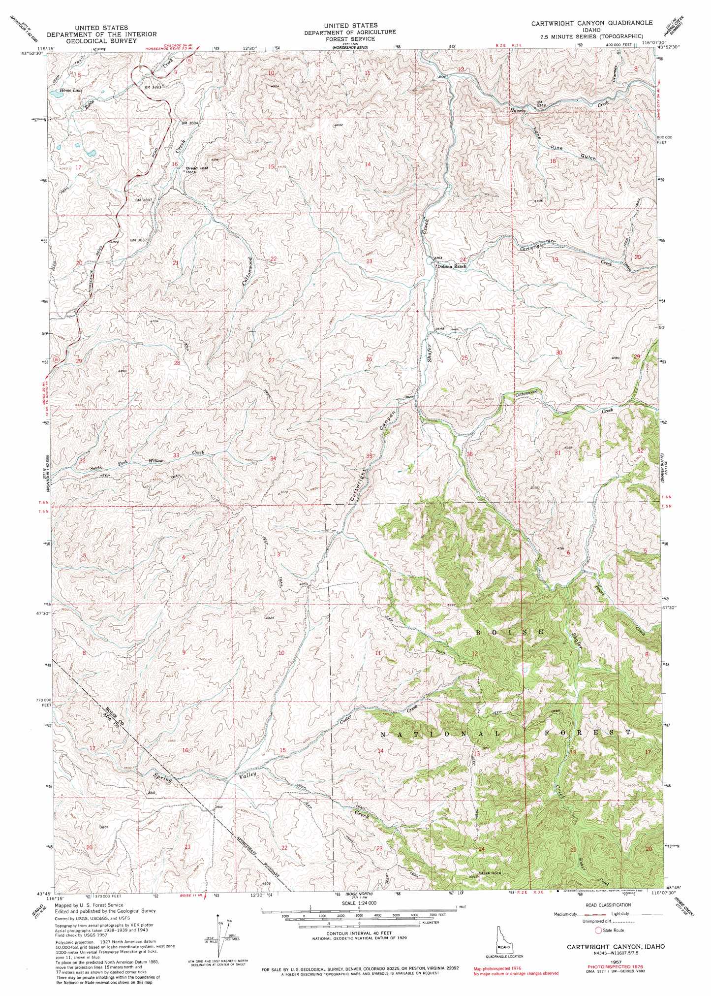
USGS Topo Quad 43116g2 - 1:24,000 scale
| Topo Map Name: | Cartwright Canyon |
| USGS Topo Quad ID: | 43116g2 |
| Print Size: | ca. 21 1/4" wide x 27" high |
| Southeast Coordinates: | 43.75° N latitude / 116.125° W longitude |
| Map Center Coordinates: | 43.8125° N latitude / 116.1875° W longitude |
| U.S. State: | ID |
| Filename: | o43116g2.jpg |
| Download Map JPG Image: | Cartwright Canyon topo map 1:24,000 scale |
| Map Type: | Topographic |
| Topo Series: | 7.5´ |
| Map Scale: | 1:24,000 |
| Source of Map Images: | United States Geological Survey (USGS) |
| Alternate Map Versions: |
Cartwright Canyon ID 1957, updated 1959 Download PDF Buy paper map Cartwright Canyon ID 1957, updated 1977 Download PDF Buy paper map Cartwright Canyon ID 1957, updated 1982 Download PDF Buy paper map Cartwright Canyon ID 1957, updated 1982 Download PDF Buy paper map Cartwright Canyon ID 1998, updated 2002 Download PDF Buy paper map Cartwright Canyon ID 2011 Download PDF Buy paper map Cartwright Canyon ID 2013 Download PDF Buy paper map |
| FStopo: | US Forest Service topo Cartwright Canyon is available: Download FStopo PDF Download FStopo TIF |
1:24,000 Topo Quads surrounding Cartwright Canyon
Squaw Butte |
Webb Creek |
Dry Buck Valley |
Banks |
Garden Valley |
Northeast Emmett |
Montour |
Horseshoe Bend |
Harris Creek Summit |
Placerville |
Southeast Emmett |
Pearl |
Cartwright Canyon |
Shafer Butte |
Warm Springs Point |
Star |
Eagle |
Boise North |
Robie Creek |
Dunnigan Creek |
Meridian |
Cloverdale |
Boise South |
Lucky Peak |
Arrowrock Dam |
> Back to 43116e1 at 1:100,000 scale
> Back to 43116a1 at 1:250,000 scale
> Back to U.S. Topo Maps home
Cartwright Canyon topo map: Gazetteer
Cartwright Canyon: Lakes
Home Lake elevation 1191m 3907′Cartwright Canyon: Pillars
Stack Rock elevation 1759m 5770′Cartwright Canyon: Streams
Bogus Creek elevation 1237m 4058′Cartwright Creek elevation 1029m 3375′
Cottonwood Creek elevation 1109m 3638′
Custer Creek elevation 1190m 3904′
Harris Creek elevation 959m 3146′
Sinker Creek elevation 1411m 4629′
Cartwright Canyon: Summits
Bread Loaf Rock elevation 1075m 3526′Cartwright Canyon: Valleys
Cartwright Canyon elevation 1094m 3589′Crumley Gulch elevation 1077m 3533′
Lone Pine Gulch elevation 1012m 3320′
Cartwright Canyon digital topo map on disk
Buy this Cartwright Canyon topo map showing relief, roads, GPS coordinates and other geographical features, as a high-resolution digital map file on DVD: