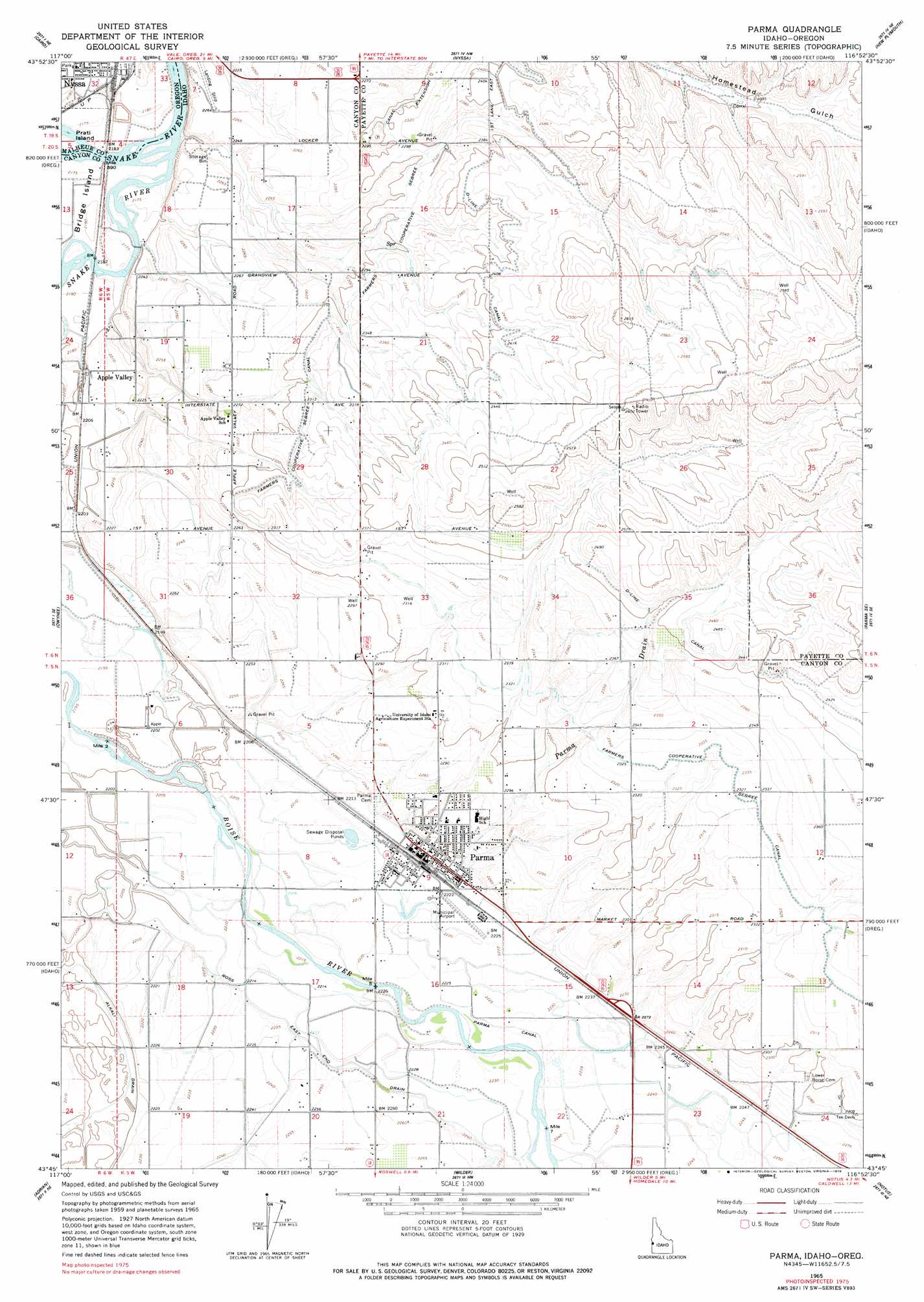
Parma Topo Map Idaho
To zoom in, hover over the map of Parma
USGS Topo Quad 43116g8 - 1:24,000 scale
| Topo Map Name: | Parma |
| USGS Topo Quad ID: | 43116g8 |
| Print Size: | ca. 21 1/4" wide x 27" high |
| Southeast Coordinates: | 43.75° N latitude / 116.875° W longitude |
| Map Center Coordinates: | 43.8125° N latitude / 116.9375° W longitude |
| U.S. States: | ID, OR |
| Filename: | o43116g8.jpg |
| Download Map JPG Image: | Parma topo map 1:24,000 scale |
| Map Type: | Topographic |
| Topo Series: | 7.5´ |
| Map Scale: | 1:24,000 |
| Source of Map Images: | United States Geological Survey (USGS) |
| Alternate Map Versions: |
Parma ID 1965, updated 1967 Download PDF Buy paper map Parma ID 1965, updated 1978 Download PDF Buy paper map Parma ID 2011 Download PDF Buy paper map Parma ID 2013 Download PDF Buy paper map |
1:24,000 Topo Quads surrounding Parma
Henry Gulch |
Malheur Butte |
Payette |
Birding Island |
Sheep Ridge |
Vale East |
Cairo |
Nyssa |
New Plymouth |
Letha |
Mitchell Butte |
Owyhee |
Parma |
Parma Se |
Sand Hollow |
Owyhee Dam |
Adrian |
Wilder |
Notus |
Caldwell |
Owyhee Ridge |
Graveyard Point |
Homedale |
Marsing |
Lake Lowell |
> Back to 43116e1 at 1:100,000 scale
> Back to 43116a1 at 1:250,000 scale
> Back to U.S. Topo Maps home
Parma topo map: Gazetteer
Parma: Airports
Parma Airport elevation 678m 2224′Parma: Canals
Alkali Drain elevation 670m 2198′D-Line Canal elevation 731m 2398′
Farmers Cooperative Sebree Canal Extension elevation 701m 2299′
Parma Canal elevation 679m 2227′
Ross East End Drain elevation 678m 2224′
Parma: Islands
McConnel Island elevation 682m 2237′Parma: Lakes
Pintail Pond elevation 670m 2198′Redhead Pond elevation 670m 2198′
Wood Duck Pond elevation 670m 2198′
Parma: Parks
South Park elevation 665m 2181′Parma: Populated Places
Apple Valley elevation 675m 2214′Parma elevation 680m 2230′
Parma: Streams
Parma Drain elevation 678m 2224′Parma digital topo map on disk
Buy this Parma topo map showing relief, roads, GPS coordinates and other geographical features, as a high-resolution digital map file on DVD: