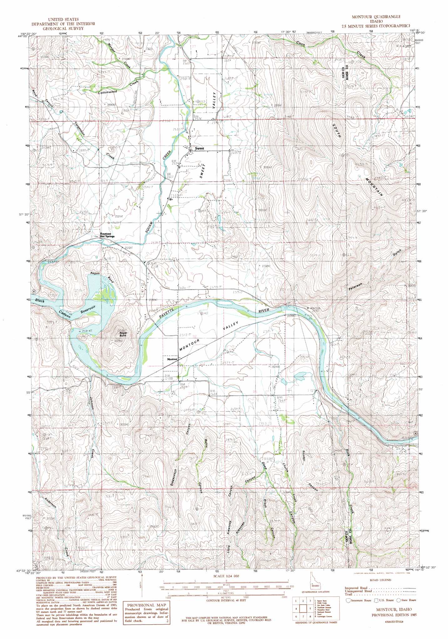
Montour Topo Map Idaho
To zoom in, hover over the map of Montour
USGS Topo Quad 43116h3 - 1:24,000 scale
| Topo Map Name: | Montour |
| USGS Topo Quad ID: | 43116h3 |
| Print Size: | ca. 21 1/4" wide x 27" high |
| Southeast Coordinates: | 43.875° N latitude / 116.25° W longitude |
| Map Center Coordinates: | 43.9375° N latitude / 116.3125° W longitude |
| U.S. State: | ID |
| Filename: | o43116h3.jpg |
| Download Map JPG Image: | Montour topo map 1:24,000 scale |
| Map Type: | Topographic |
| Topo Series: | 7.5´ |
| Map Scale: | 1:24,000 |
| Source of Map Images: | United States Geological Survey (USGS) |
| Alternate Map Versions: |
Montour ID 1985, updated 1986 Download PDF Buy paper map Montour ID 2010 Download PDF Buy paper map Montour ID 2013 Download PDF Buy paper map |
1:24,000 Topo Quads surrounding Montour
Paddock Valley Reservoir |
Coonrod Gulch |
Ola |
High Valley |
Packer John Mountain |
Hog Cove Butte |
Squaw Butte |
Webb Creek |
Dry Buck Valley |
Banks |
Northwest Emmett |
Northeast Emmett |
Montour |
Horseshoe Bend |
Harris Creek Summit |
Southwest Emmett |
Southeast Emmett |
Pearl |
Cartwright Canyon |
Shafer Butte |
Middleton |
Star |
Eagle |
Boise North |
Robie Creek |
> Back to 43116e1 at 1:100,000 scale
> Back to 43116a1 at 1:250,000 scale
> Back to U.S. Topo Maps home
Montour topo map: Gazetteer
Montour: Basins
Montour Valley elevation 769m 2522′Montour: Bends
Regan Bend elevation 793m 2601′Montour: Dams
Gatfield Number Two Dam elevation 822m 2696′Montour: Populated Places
Marsh (historical) elevation 775m 2542′Montour elevation 766m 2513′
Sweet elevation 780m 2559′
Montour: Springs
Roystone Hot Springs elevation 786m 2578′Montour: Streams
Church Creek elevation 801m 2627′Coon Creek elevation 780m 2559′
Cottonwood Creek elevation 780m 2559′
Johnson Creek elevation 762m 2500′
Monger Creek elevation 802m 2631′
Rock Creek elevation 781m 2562′
Squaw Creek elevation 764m 2506′
Yergenson Creek elevation 771m 2529′
Montour: Summits
Regan Butte elevation 1005m 3297′South Mountain elevation 1396m 4580′
Montour: Valleys
Arkansas Canyon elevation 871m 2857′Baltic Canyon elevation 837m 2746′
Brush Canyon elevation 880m 2887′
Deep Canyon elevation 788m 2585′
Little Arkansas Canyon elevation 934m 3064′
Peterson Gulch elevation 786m 2578′
Snyder Canyon elevation 842m 2762′
Stagecoach Canyon elevation 847m 2778′
Sweet Valley elevation 764m 2506′
Montour digital topo map on disk
Buy this Montour topo map showing relief, roads, GPS coordinates and other geographical features, as a high-resolution digital map file on DVD: