Nyssa Topo Map Idaho
To zoom in, hover over the map of Nyssa
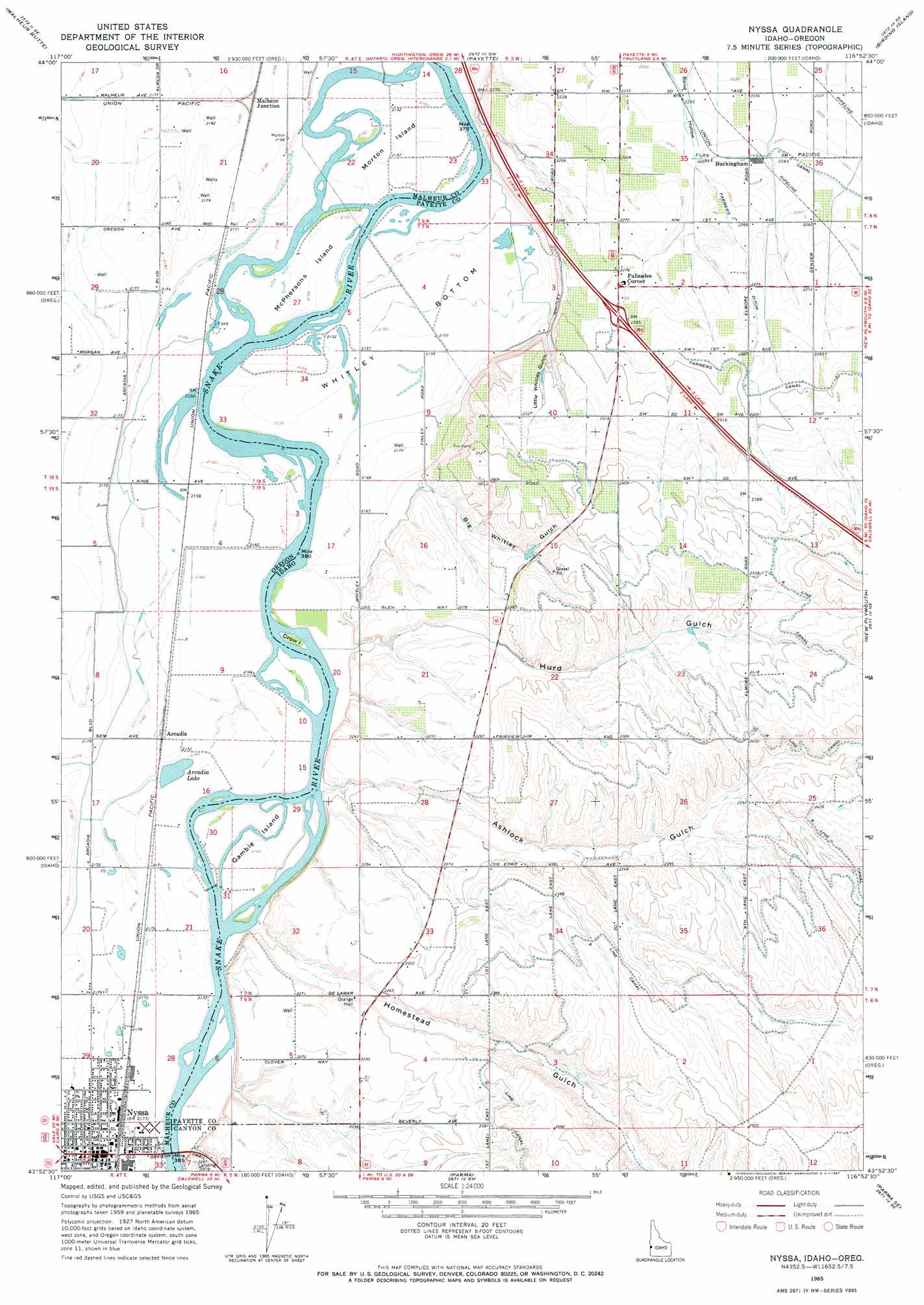
USGS Topo Quad 43116h8 - 1:24,000 scale
| Topo Map Name: | Nyssa |
| USGS Topo Quad ID: | 43116h8 |
| Print Size: | ca. 21 1/4" wide x 27" high |
| Southeast Coordinates: | 43.875° N latitude / 116.875° W longitude |
| Map Center Coordinates: | 43.9375° N latitude / 116.9375° W longitude |
| U.S. States: | ID, OR |
| Filename: | o43116h8.jpg |
| Download Map JPG Image: | Nyssa topo map 1:24,000 scale |
| Map Type: | Topographic |
| Topo Series: | 7.5´ |
| Map Scale: | 1:24,000 |
| Source of Map Images: | United States Geological Survey (USGS) |
| Alternate Map Versions: |
Nyssa OR 1965, updated 1967 Download PDF Buy paper map Nyssa OR 2011 Download PDF Buy paper map Nyssa OR 2014 Download PDF Buy paper map |
1:24,000 Topo Quads surrounding Nyssa
Tub Mountain |
Moores Hollow |
Weiser South |
Weiser Cove |
Holland Gulch |
Henry Gulch |
Malheur Butte |
Payette |
Birding Island |
Sheep Ridge |
Vale East |
Cairo |
Nyssa |
New Plymouth |
Letha |
Mitchell Butte |
Owyhee |
Parma |
Parma Se |
Sand Hollow |
Owyhee Dam |
Adrian |
Wilder |
Notus |
Caldwell |
> Back to 43116e1 at 1:100,000 scale
> Back to 43116a1 at 1:250,000 scale
> Back to U.S. Topo Maps home
Nyssa topo map: Gazetteer
Nyssa: Bends
Whitley Bottom elevation 658m 2158′Nyssa: Canals
A Line Canal elevation 746m 2447′Valley View Drain elevation 665m 2181′
Nyssa: Dams
Surmeier Dam elevation 702m 2303′Nyssa: Guts
Penn Slough elevation 659m 2162′Nyssa: Islands
Crow Island elevation 658m 2158′Gamble Island elevation 661m 2168′
McPhersons Island elevation 657m 2155′
Morton Island elevation 657m 2155′
Perrin Island elevation 657m 2155′
Nyssa: Parks
North Park elevation 664m 2178′River Park elevation 663m 2175′
Nyssa: Populated Places
Arcadia elevation 662m 2171′Buckingham elevation 685m 2247′
Nyssa elevation 664m 2178′
Palisades Corner elevation 695m 2280′
Nyssa: Post Offices
Arcadia Post Office (historical) elevation 662m 2171′Morton Post Office (historical) elevation 661m 2168′
Nyssa Post Office elevation 664m 2178′
Nyssa: Reservoirs
Arcadia Lake elevation 658m 2158′Nyssa: Streams
Plummer Slough elevation 659m 2162′Nyssa: Valleys
Ashlock Gulch elevation 664m 2178′Big Whitley Gulch elevation 670m 2198′
Homestead Gulch elevation 660m 2165′
Hurd Gulch elevation 661m 2168′
Little Whitley Gulch elevation 676m 2217′
Nyssa digital topo map on disk
Buy this Nyssa topo map showing relief, roads, GPS coordinates and other geographical features, as a high-resolution digital map file on DVD: