Diamond Butte Topo Map Oregon
To zoom in, hover over the map of Diamond Butte
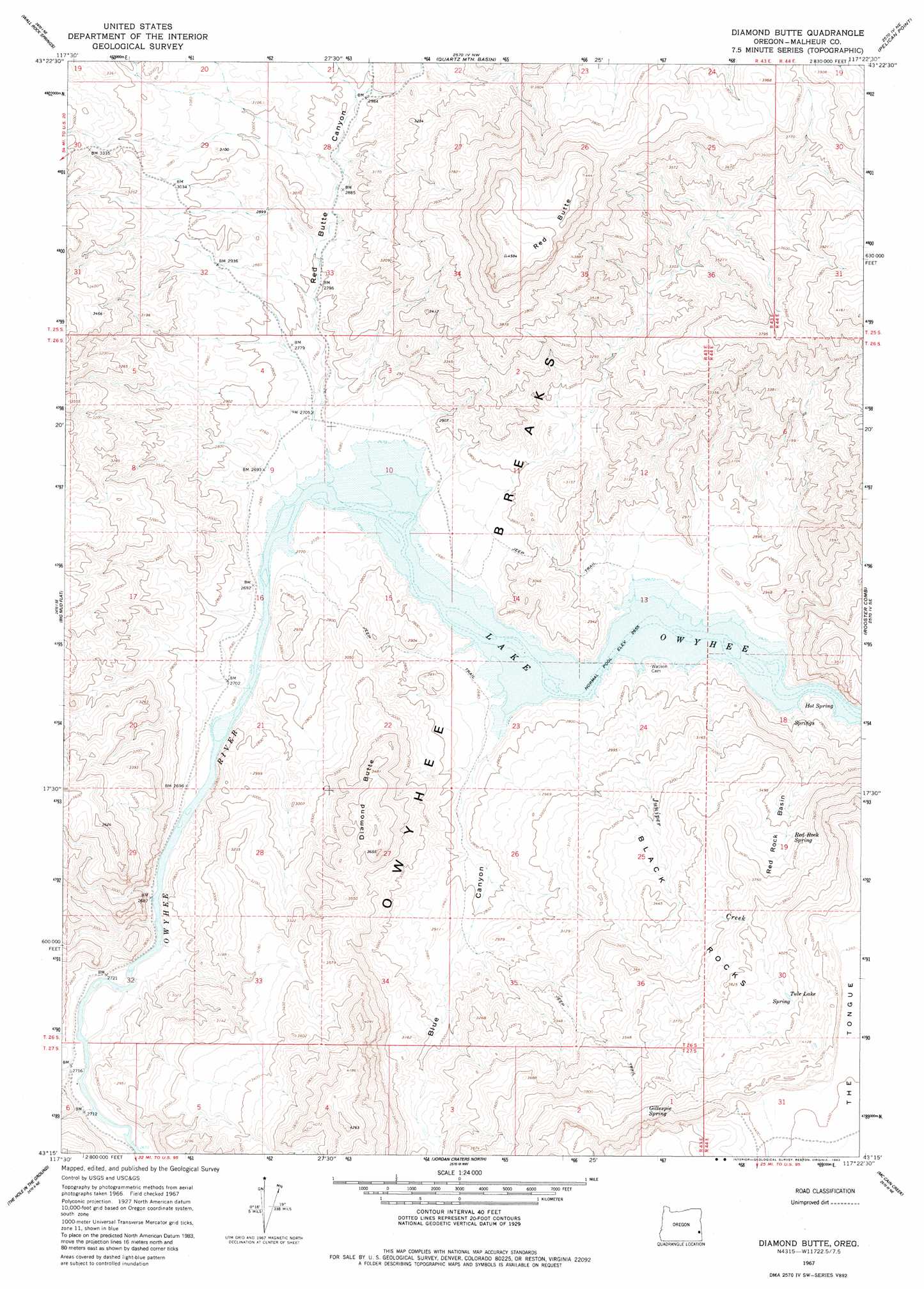
USGS Topo Quad 43117c4 - 1:24,000 scale
| Topo Map Name: | Diamond Butte |
| USGS Topo Quad ID: | 43117c4 |
| Print Size: | ca. 21 1/4" wide x 27" high |
| Southeast Coordinates: | 43.25° N latitude / 117.375° W longitude |
| Map Center Coordinates: | 43.3125° N latitude / 117.4375° W longitude |
| U.S. State: | OR |
| Filename: | o43117c4.jpg |
| Download Map JPG Image: | Diamond Butte topo map 1:24,000 scale |
| Map Type: | Topographic |
| Topo Series: | 7.5´ |
| Map Scale: | 1:24,000 |
| Source of Map Images: | United States Geological Survey (USGS) |
| Alternate Map Versions: |
Diamond Butte OR 1967, updated 1971 Download PDF Buy paper map Diamond Butte OR 1967, updated 1983 Download PDF Buy paper map Diamond Butte OR 1967, updated 1983 Download PDF Buy paper map Diamond Butte OR 2011 Download PDF Buy paper map Diamond Butte OR 2014 Download PDF Buy paper map |
1:24,000 Topo Quads surrounding Diamond Butte
Rufino Butte |
Hurley Flat |
Twin Springs |
The Elbow |
Owyhee Ridge |
Copeland Reservoirs |
Wall Rock Springs |
Quartz Mountain Basin |
Pelican Point |
Three Fingers Rock |
Cedar Mountain |
Big Mud Flat |
Diamond Butte |
Rooster Comb |
Bannock Ridge |
Rinehart Canyon |
The Hole In The Ground |
Jordan Craters North |
Mccain Creek |
Mahogany Gap |
Lambert Rocks |
Bogus Bench |
Jordan Craters South |
Cow Lakes |
Downey Canyon |
> Back to 43117a1 at 1:100,000 scale
> Back to 43116a1 at 1:250,000 scale
> Back to U.S. Topo Maps home
Diamond Butte topo map: Gazetteer
Diamond Butte: Areas
Black Rocks elevation 1046m 3431′Diamond Butte: Basins
Red Rock Basin elevation 1039m 3408′Diamond Butte: Lakes
Tule Lake elevation 1200m 3937′Diamond Butte: Populated Places
Watson (historical) elevation 812m 2664′Diamond Butte: Post Offices
Watson Post Office (historical) elevation 812m 2664′Diamond Butte: Springs
Gillespie Spring elevation 1229m 4032′Hot Spring elevation 824m 2703′
Red Rock Spring elevation 1056m 3464′
Diamond Butte: Streams
Juniper Creek elevation 818m 2683′Diamond Butte: Summits
Diamond Butte elevation 1110m 3641′Red Butte elevation 1388m 4553′
Diamond Butte: Valleys
Blue Canyon elevation 816m 2677′Red Butte Canyon elevation 829m 2719′
Diamond Butte digital topo map on disk
Buy this Diamond Butte topo map showing relief, roads, GPS coordinates and other geographical features, as a high-resolution digital map file on DVD: