Three Fingers Rock Topo Map Oregon
To zoom in, hover over the map of Three Fingers Rock
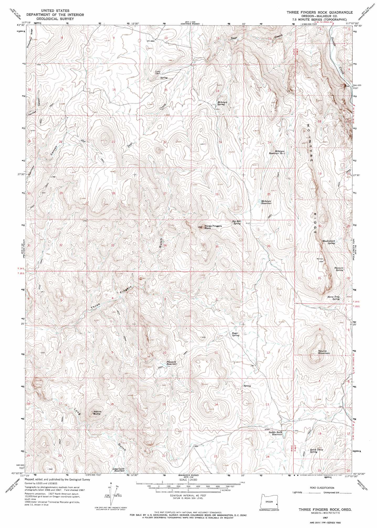
USGS Topo Quad 43117d2 - 1:24,000 scale
| Topo Map Name: | Three Fingers Rock |
| USGS Topo Quad ID: | 43117d2 |
| Print Size: | ca. 21 1/4" wide x 27" high |
| Southeast Coordinates: | 43.375° N latitude / 117.125° W longitude |
| Map Center Coordinates: | 43.4375° N latitude / 117.1875° W longitude |
| U.S. State: | OR |
| Filename: | o43117d2.jpg |
| Download Map JPG Image: | Three Fingers Rock topo map 1:24,000 scale |
| Map Type: | Topographic |
| Topo Series: | 7.5´ |
| Map Scale: | 1:24,000 |
| Source of Map Images: | United States Geological Survey (USGS) |
| Alternate Map Versions: |
Three Fingers Rock OR 1967, updated 1971 Download PDF Buy paper map Three Fingers Rock OR 2011 Download PDF Buy paper map Three Fingers Rock OR 2014 Download PDF Buy paper map |
1:24,000 Topo Quads surrounding Three Fingers Rock
Sourdough Spring |
Grassy Mountain |
Owyhee Dam |
Adrian |
Wilder |
Twin Springs |
The Elbow |
Owyhee Ridge |
Graveyard Point |
Homedale |
Quartz Mountain Basin |
Pelican Point |
Three Fingers Rock |
Pole Creek Top |
Jump Creek Canyon |
Diamond Butte |
Rooster Comb |
Bannock Ridge |
Rockville |
Piute Butte |
Jordan Craters North |
Mccain Creek |
Mahogany Gap |
Sheaville |
Captain Butte |
> Back to 43117a1 at 1:100,000 scale
> Back to 43116a1 at 1:250,000 scale
> Back to U.S. Topo Maps home
Three Fingers Rock topo map: Gazetteer
Three Fingers Rock: Parks
Succor Creek State Park elevation 1135m 3723′Three Fingers Rock: Reservoirs
Bar Cross Basin Reservoir elevation 1161m 3809′Coyote Reservoir elevation 1103m 3618′
Long Gulch Reservoir elevation 1082m 3549′
McIntyre Reservoir elevation 1230m 4035′
McIntyre Reservoir Number Two elevation 1179m 3868′
Pinnacle Reservoir elevation 1115m 3658′
Saddle Butte Reservoir elevation 1158m 3799′
Sheephead Reservoir elevation 1268m 4160′
Three Fingers Rock: Ridges
McIntyre Ridge elevation 1422m 4665′Three Fingers Rock: Springs
Big Hill Spring elevation 1266m 4153′Buzzard Spring elevation 1183m 3881′
Horse Trap Spring elevation 1147m 3763′
McIntyre Spring elevation 1166m 3825′
Meadowlark Spring elevation 1141m 3743′
Quick Draw Spring elevation 1186m 3891′
Roger Spring elevation 1134m 3720′
Three Fingers Rock: Summits
Acton Butte elevation 1254m 4114′Atkins Butte elevation 1249m 4097′
Round Mountain elevation 1439m 4721′
Three Fingers Rock elevation 1458m 4783′
Three Fingers Rock: Valleys
Board Corral Gulch elevation 1146m 3759′Three Fingers Rock digital topo map on disk
Buy this Three Fingers Rock topo map showing relief, roads, GPS coordinates and other geographical features, as a high-resolution digital map file on DVD: