Vale East Topo Map Oregon
To zoom in, hover over the map of Vale East
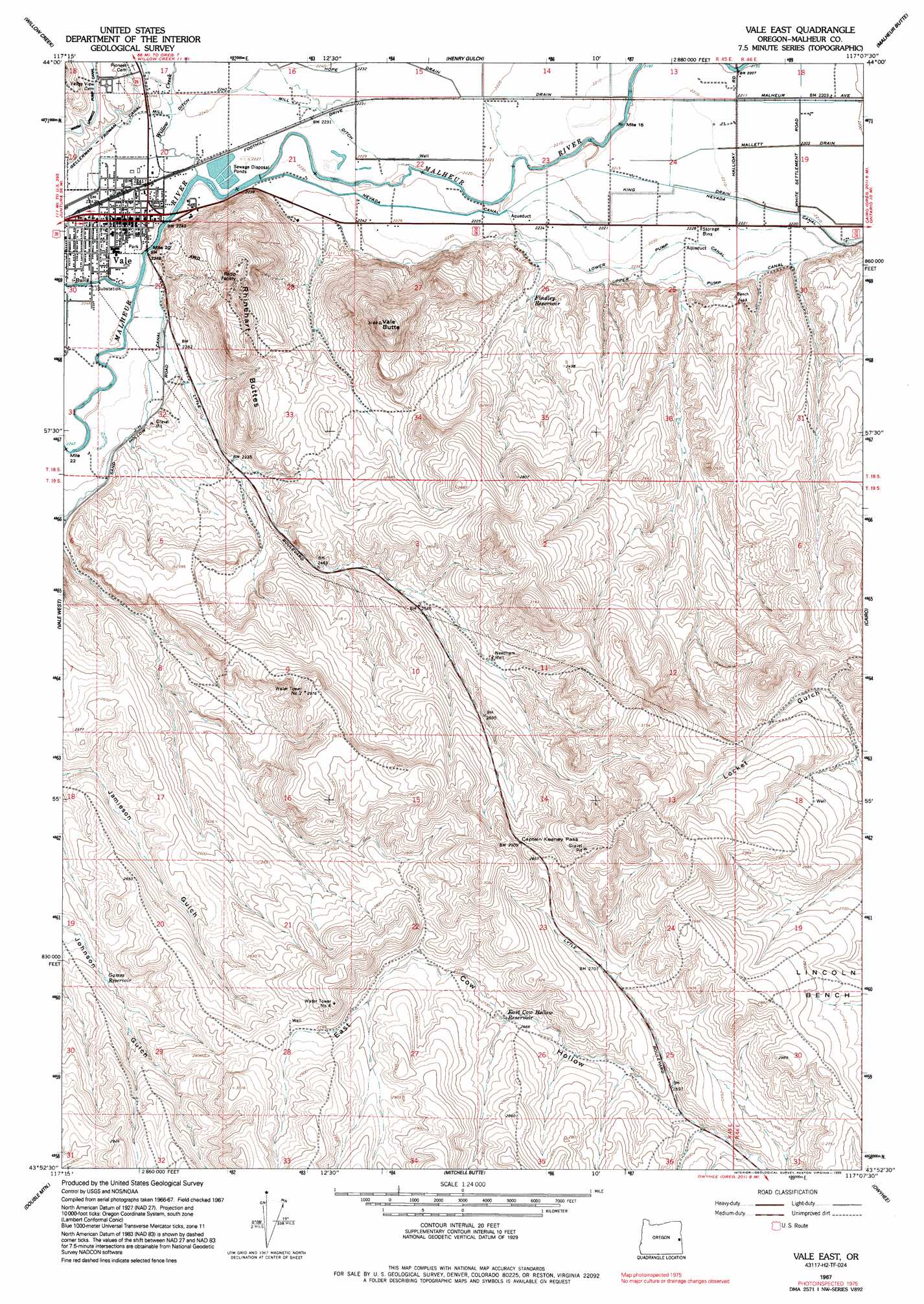
USGS Topo Quad 43117h2 - 1:24,000 scale
| Topo Map Name: | Vale East |
| USGS Topo Quad ID: | 43117h2 |
| Print Size: | ca. 21 1/4" wide x 27" high |
| Southeast Coordinates: | 43.875° N latitude / 117.125° W longitude |
| Map Center Coordinates: | 43.9375° N latitude / 117.1875° W longitude |
| U.S. State: | OR |
| Filename: | o43117h2.jpg |
| Download Map JPG Image: | Vale East topo map 1:24,000 scale |
| Map Type: | Topographic |
| Topo Series: | 7.5´ |
| Map Scale: | 1:24,000 |
| Source of Map Images: | United States Geological Survey (USGS) |
| Alternate Map Versions: |
Vale East OR 1967, updated 1971 Download PDF Buy paper map Vale East OR 1967, updated 1981 Download PDF Buy paper map Vale East OR 1967, updated 1995 Download PDF Buy paper map Vale East OR 2011 Download PDF Buy paper map Vale East OR 2014 Download PDF Buy paper map |
1:24,000 Topo Quads surrounding Vale East
Jamieson |
Mccarthy Ridge |
Tub Mountain |
Moores Hollow |
Weiser South |
Hope Butte |
Willow Creek |
Henry Gulch |
Malheur Butte |
Payette |
Vines Hill |
Vale West |
Vale East |
Cairo |
Nyssa |
Kane Spring Gulch |
Double Mountain |
Mitchell Butte |
Owyhee |
Parma |
Sourdough Spring |
Grassy Mountain |
Owyhee Dam |
Adrian |
Wilder |
> Back to 43117e1 at 1:100,000 scale
> Back to 43116a1 at 1:250,000 scale
> Back to U.S. Topo Maps home
Vale East topo map: Gazetteer
Vale East: Canals
Hope Drain elevation 681m 2234′King Drain elevation 676m 2217′
Lower Pump Canal elevation 683m 2240′
Mill Ditch elevation 681m 2234′
Upper Pump Canal elevation 690m 2263′
Vale East: Gaps
Captain Keeney Pass elevation 881m 2890′Vale East: Parks
Cottonwood City Park elevation 685m 2247′Lewin City Park elevation 684m 2244′
Wadleigh City Park elevation 684m 2244′
Vale East: Populated Places
Vale elevation 684m 2244′Vale East: Post Offices
Vale Post Office elevation 684m 2244′Vale East: Reservoirs
East Cow Hollow Reservoir elevation 818m 2683′Findley Reservoir elevation 700m 2296′
Games Reservoir elevation 758m 2486′
Jamieson Gulch Reservoir elevation 763m 2503′
Needham Reservoir elevation 813m 2667′
Vale East: Springs
Vale Hot Springs elevation 689m 2260′Vale East: Streams
Bully Creek elevation 684m 2244′Willow Creek elevation 681m 2234′
Vale East: Summits
Rhinehart Buttes elevation 886m 2906′Vale Butte elevation 959m 3146′
Vale East: Valleys
Vale Valley elevation 678m 2224′Vale East: Wells
Needham Well elevation 813m 2667′Vale East digital topo map on disk
Buy this Vale East topo map showing relief, roads, GPS coordinates and other geographical features, as a high-resolution digital map file on DVD: