Palomino Buttes Topo Map Oregon
To zoom in, hover over the map of Palomino Buttes
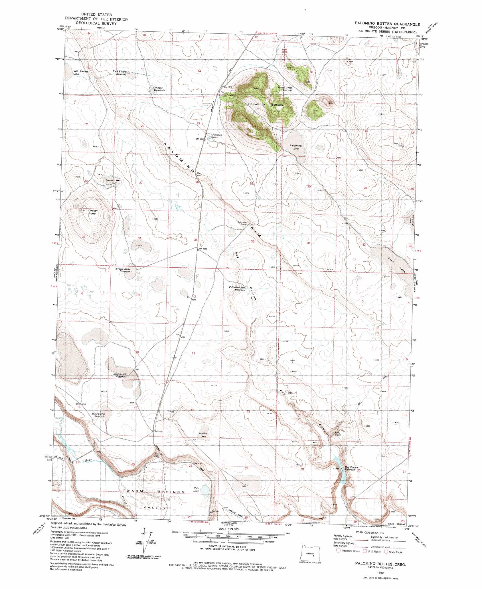
USGS Topo Quad 43119d3 - 1:24,000 scale
| Topo Map Name: | Palomino Buttes |
| USGS Topo Quad ID: | 43119d3 |
| Print Size: | ca. 21 1/4" wide x 27" high |
| Southeast Coordinates: | 43.375° N latitude / 119.25° W longitude |
| Map Center Coordinates: | 43.4375° N latitude / 119.3125° W longitude |
| U.S. State: | OR |
| Filename: | o43119d3.jpg |
| Download Map JPG Image: | Palomino Buttes topo map 1:24,000 scale |
| Map Type: | Topographic |
| Topo Series: | 7.5´ |
| Map Scale: | 1:24,000 |
| Source of Map Images: | United States Geological Survey (USGS) |
| Alternate Map Versions: |
Palomino Buttes OR 1980, updated 1980 Download PDF Buy paper map Palomino Buttes OR 2011 Download PDF Buy paper map Palomino Buttes OR 2014 Download PDF Buy paper map |
1:24,000 Topo Quads surrounding Palomino Buttes
Dry Mountain |
Egypt Canyon |
Holmes Canyon |
Burns Ne |
Poison Creek |
Riley |
Oakerman Lakes |
Sage Hen Hill |
Burns Butte |
Burns |
Capehart Lake |
Moon Reservoir |
Palomino Buttes |
Weaver Lake |
Dog Mountain |
Lake On The Trail |
Iron Mountain Flat |
Stinking Lake |
Northwest Harney Lake |
Northeast Harney Lake |
Wilson Butte |
Lunch Lake |
Hughet Spring |
Southwest Harney Lake |
Southeast Harney Lake |
> Back to 43119a1 at 1:100,000 scale
> Back to 43118a1 at 1:250,000 scale
> Back to U.S. Topo Maps home
Palomino Buttes topo map: Gazetteer
Palomino Buttes: Cliffs
Palomino Rim elevation 1360m 4461′Palomino Buttes: Dams
Fay Canyon Dam elevation 1261m 4137′Palomino Buttes: Flats
Wildhorse Lake elevation 1330m 4363′Palomino Buttes: Lakes
Chain Lake elevation 1345m 4412′Cote Lake elevation 1260m 4133′
Grassy Lake elevation 1323m 4340′
Lone Rabbit Water Hole elevation 1306m 4284′
Obiaque Water Hole elevation 1364m 4475′
Palomino Lake elevation 1379m 4524′
Umbrite Lake elevation 1287m 4222′
West Chain Lake elevation 1350m 4429′
Palomino Buttes: Reservoirs
Bunch Grass Reservoir elevation 1379m 4524′Fay Canyon Reservoir elevation 1261m 4137′
Grassy Butte Reservoir elevation 1320m 4330′
Palomino Rim Reservoir elevation 1303m 4274′
Pay Canyon Reservoir elevation 1262m 4140′
Rock Bottom Reservoir elevation 1361m 4465′
Snow Storm Reservoir elevation 1301m 4268′
Palomino Buttes: Slopes
Palomino Grade elevation 1351m 4432′Palomino Buttes: Streams
Cote Slough elevation 1278m 4192′Palomino Buttes: Summits
Grassy Butte elevation 1377m 4517′Palomino Buttes elevation 1489m 4885′
Palomino Mountain elevation 1474m 4835′
Palomino Buttes: Valleys
Fay Canyon elevation 1261m 4137′Palomino Buttes digital topo map on disk
Buy this Palomino Buttes topo map showing relief, roads, GPS coordinates and other geographical features, as a high-resolution digital map file on DVD: