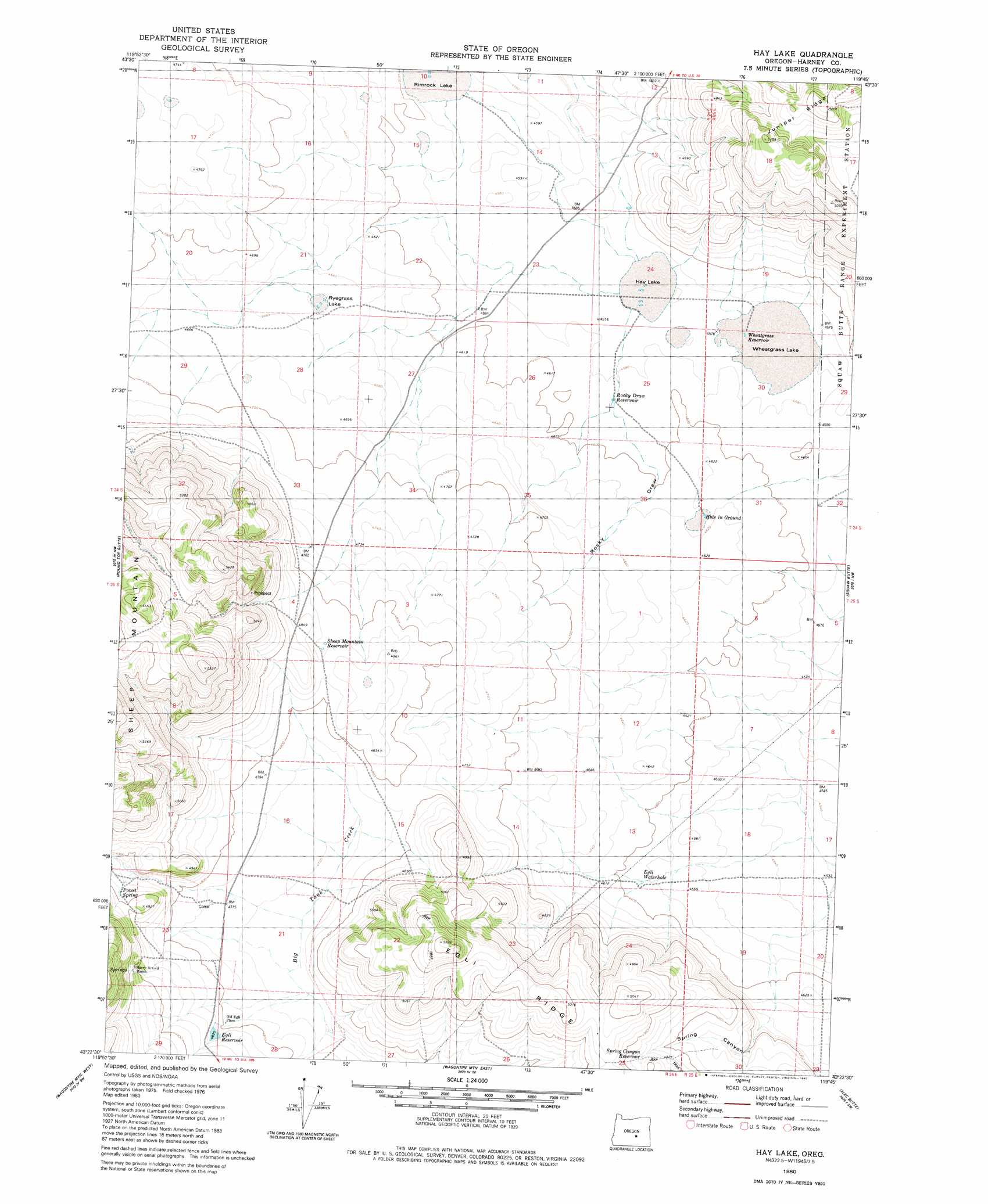
Hay Lake Topo Map Oregon
To zoom in, hover over the map of Hay Lake
USGS Topo Quad 43119d7 - 1:24,000 scale
| Topo Map Name: | Hay Lake |
| USGS Topo Quad ID: | 43119d7 |
| Print Size: | ca. 21 1/4" wide x 27" high |
| Southeast Coordinates: | 43.375° N latitude / 119.75° W longitude |
| Map Center Coordinates: | 43.4375° N latitude / 119.8125° W longitude |
| U.S. State: | OR |
| Filename: | o43119d7.jpg |
| Download Map JPG Image: | Hay Lake topo map 1:24,000 scale |
| Map Type: | Topographic |
| Topo Series: | 7.5´ |
| Map Scale: | 1:24,000 |
| Source of Map Images: | United States Geological Survey (USGS) |
| Alternate Map Versions: |
Hay Lake OR 1980, updated 1980 Download PDF Buy paper map Hay Lake OR 2011 Download PDF Buy paper map Hay Lake OR 2014 Download PDF Buy paper map |
1:24,000 Topo Quads surrounding Hay Lake
Misery Flat |
Dust Bowl |
Bulger Ridge |
Camp Currey Spring |
Dry Mountain |
Glass Butte |
Hat Butte |
Potato Hills |
Suntex |
Riley |
Tired Horse Butte |
Round Top Butte |
Hay Lake |
Squaw Butte |
Capehart Lake |
Rams Butte |
Wagontire Mountain West |
Wagontire Mountain East |
Alec Butte |
Lake On The Trail |
Goodrich Well |
Locust Butte |
Little Juniper Mountain |
Goose Egg Butte |
Wilson Butte |
> Back to 43119a1 at 1:100,000 scale
> Back to 43118a1 at 1:250,000 scale
> Back to U.S. Topo Maps home
Hay Lake topo map: Gazetteer
Hay Lake: Flats
Hay Lake elevation 1396m 4580′Hole in Ground elevation 1409m 4622′
Wheatgrass Lake elevation 1396m 4580′
Hay Lake: Lakes
Hay Lake elevation 1396m 4580′Ryegrass Lake elevation 1422m 4665′
Hay Lake: Reservoirs
Egli Waterhole elevation 1399m 4589′Indian Brave Reservoir elevation 1409m 4622′
Rocky Draw Reservoir elevation 1399m 4589′
Sheep Mountain Reservoir elevation 1469m 4819′
Spring Canyon Reservoir elevation 1482m 4862′
Surprise Lake Reservoir elevation 1422m 4665′
Wheatgrass Reservoir elevation 1396m 4580′
Hay Lake: Springs
Harry Arnold Spring elevation 1513m 4963′Poteet Spring elevation 1490m 4888′
Hay Lake: Valleys
Rocky Draw elevation 1403m 4603′Spring Canyon elevation 1421m 4662′
Hay Lake digital topo map on disk
Buy this Hay Lake topo map showing relief, roads, GPS coordinates and other geographical features, as a high-resolution digital map file on DVD: