Poison Creek Topo Map Oregon
To zoom in, hover over the map of Poison Creek
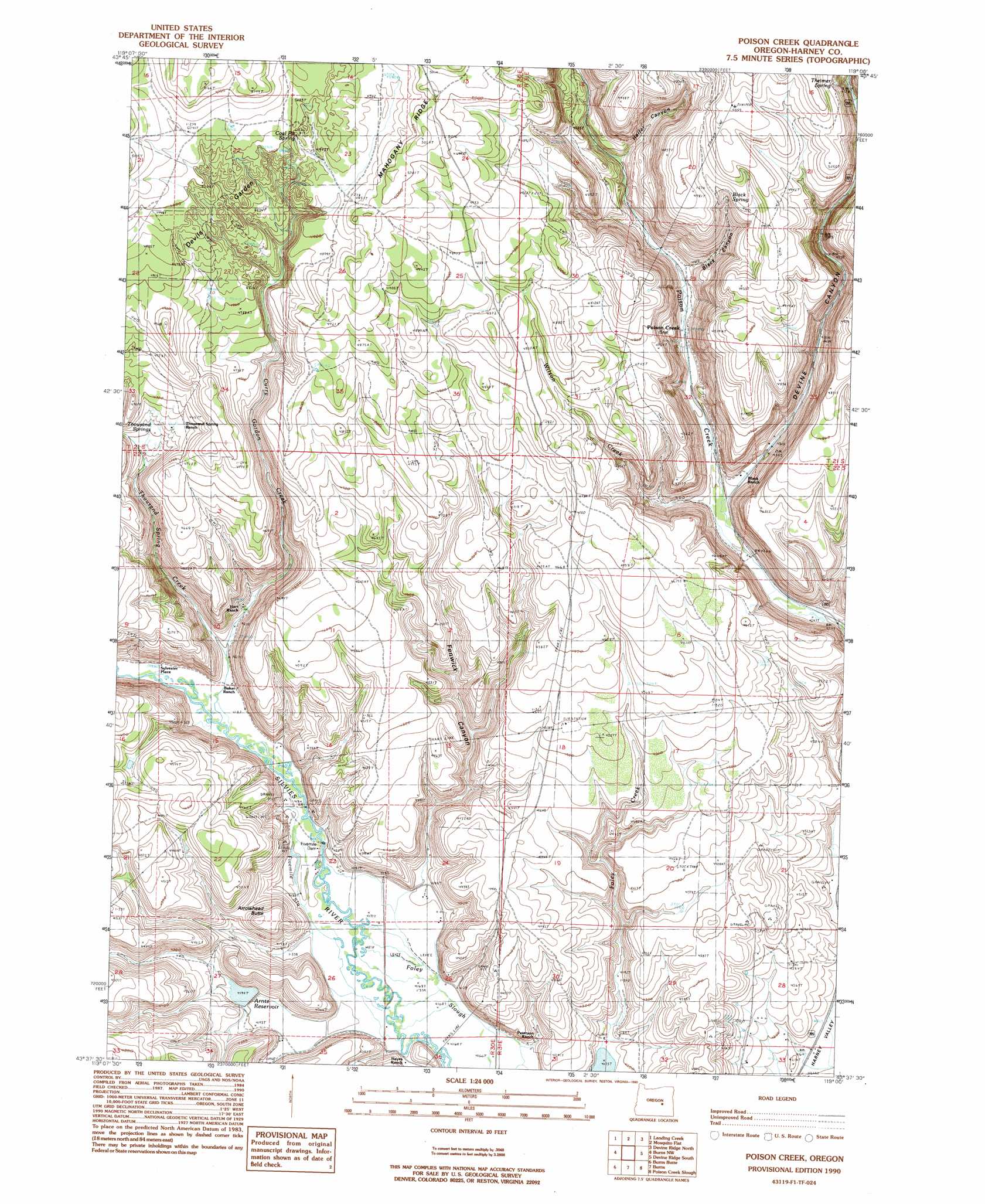
USGS Topo Quad 43119f1 - 1:24,000 scale
| Topo Map Name: | Poison Creek |
| USGS Topo Quad ID: | 43119f1 |
| Print Size: | ca. 21 1/4" wide x 27" high |
| Southeast Coordinates: | 43.625° N latitude / 119° W longitude |
| Map Center Coordinates: | 43.6875° N latitude / 119.0625° W longitude |
| U.S. State: | OR |
| Filename: | o43119f1.jpg |
| Download Map JPG Image: | Poison Creek topo map 1:24,000 scale |
| Map Type: | Topographic |
| Topo Series: | 7.5´ |
| Map Scale: | 1:24,000 |
| Source of Map Images: | United States Geological Survey (USGS) |
| Alternate Map Versions: |
Poison Creek OR 1990, updated 1990 Download PDF Buy paper map Poison Creek OR 2011 Download PDF Buy paper map Poison Creek OR 2014 Download PDF Buy paper map |
1:24,000 Topo Quads surrounding Poison Creek
Alsup Mountain |
West Myrtle Butte |
Myrtle Park Meadows |
Trout Creek |
Calamity Butte |
Hughet Valley |
Landing Creek |
Mosquito Flat |
Devine Ridge North |
Telephone Butte |
Holmes Canyon |
Burns Ne |
Poison Creek |
Devine Ridge South |
Harney |
Sage Hen Hill |
Burns Butte |
Burns |
Poison Creek Slough |
Ninemile Slough |
Palomino Buttes |
Weaver Lake |
Dog Mountain |
Redess |
Lawen |
> Back to 43119e1 at 1:100,000 scale
> Back to 43118a1 at 1:250,000 scale
> Back to U.S. Topo Maps home
Poison Creek topo map: Gazetteer
Poison Creek: Areas
Devils Garden elevation 1501m 4924′Poison Creek: Dams
Arntz Dam elevation 1281m 4202′Fivemile Dam elevation 1277m 4189′
Poison Creek: Reservoirs
Arntz Reservoir elevation 1281m 4202′Poison Creek: Springs
Black Spring elevation 1469m 4819′Coal Pit Spring elevation 1521m 4990′
Theimer Spring elevation 1515m 4970′
Thousand Springs elevation 1409m 4622′
Poison Creek: Streams
Curry Gordon Creek elevation 1280m 4199′Fivemile Slough elevation 1271m 4169′
Foley Creek elevation 1275m 4183′
Savage Slough elevation 1278m 4192′
Thousand Springs Creek elevation 1308m 4291′
Wilson Creek elevation 1303m 4274′
Poison Creek: Summits
Arrowhead Butte elevation 1355m 4445′Poison Creek: Valleys
Black Canyon elevation 1331m 4366′Devine Canyon elevation 1304m 4278′
Fenwick Canyon elevation 1285m 4215′
Gradon Canyon elevation 1289m 4229′
Theimer Canyon elevation 1444m 4737′
Poison Creek digital topo map on disk
Buy this Poison Creek topo map showing relief, roads, GPS coordinates and other geographical features, as a high-resolution digital map file on DVD: