Myrtle Park Meadows Topo Map Oregon
To zoom in, hover over the map of Myrtle Park Meadows
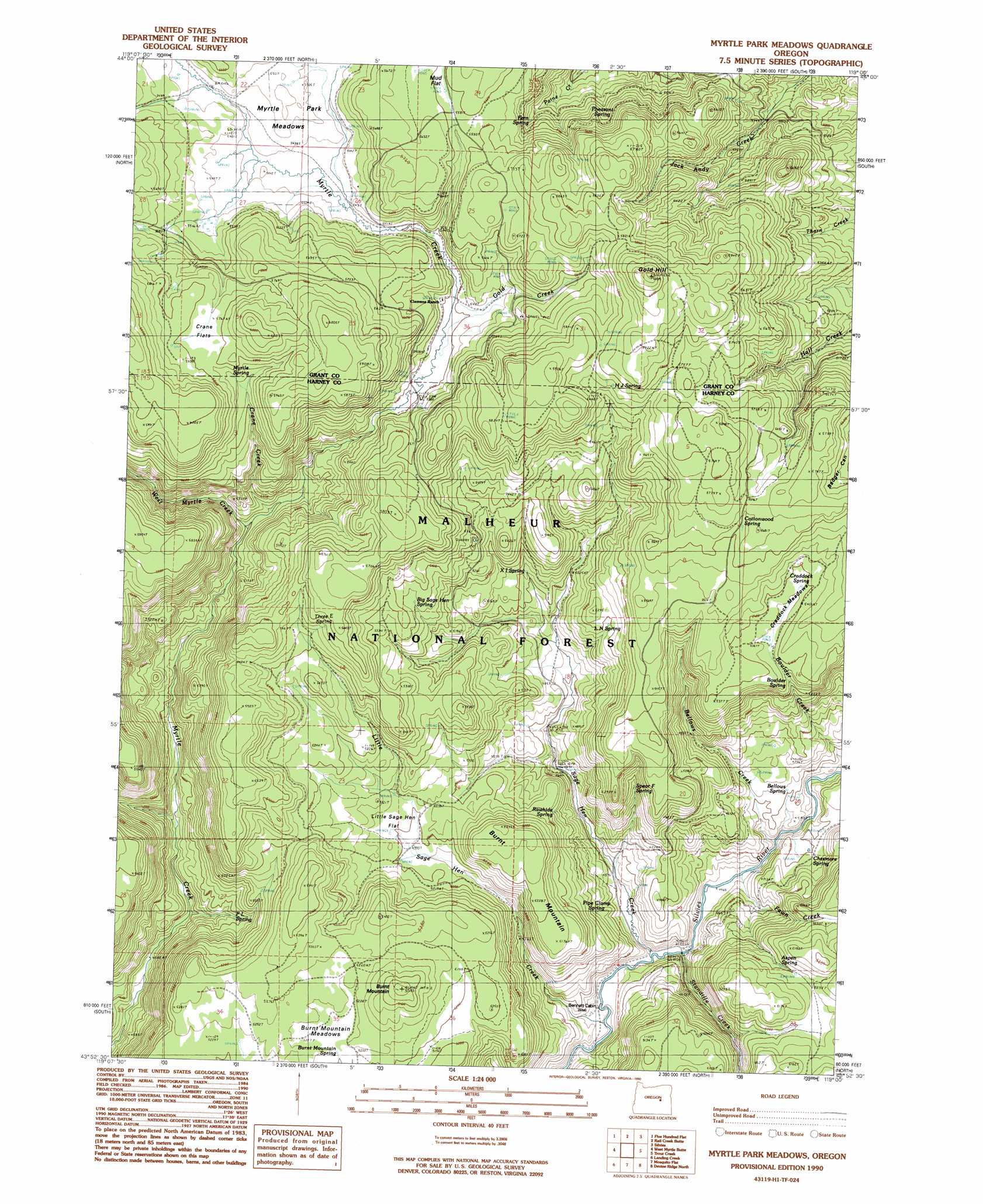
USGS Topo Quad 43119h1 - 1:24,000 scale
| Topo Map Name: | Myrtle Park Meadows |
| USGS Topo Quad ID: | 43119h1 |
| Print Size: | ca. 21 1/4" wide x 27" high |
| Southeast Coordinates: | 43.875° N latitude / 119° W longitude |
| Map Center Coordinates: | 43.9375° N latitude / 119.0625° W longitude |
| U.S. State: | OR |
| Filename: | o43119h1.jpg |
| Download Map JPG Image: | Myrtle Park Meadows topo map 1:24,000 scale |
| Map Type: | Topographic |
| Topo Series: | 7.5´ |
| Map Scale: | 1:24,000 |
| Source of Map Images: | United States Geological Survey (USGS) |
| Alternate Map Versions: |
Myrtle Park Meadows OR 1990, updated 1990 Download PDF Buy paper map Myrtle Park Meadows OR 1999, updated 2002 Download PDF Buy paper map Myrtle Park Meadows OR 2011 Download PDF Buy paper map Myrtle Park Meadows OR 2014 Download PDF Buy paper map |
| FStopo: | US Forest Service topo Myrtle Park Meadows is available: Download FStopo PDF Download FStopo TIF |
1:24,000 Topo Quads surrounding Myrtle Park Meadows
Flagtail Mountain |
Logdell |
Scotty Creek |
Seneca |
Big Canyon |
Lewis Creek |
Five Hundred Flat |
Rail Creek Butte |
Silvies |
Jumpoff Joe Mountain |
Alsup Mountain |
West Myrtle Butte |
Myrtle Park Meadows |
Trout Creek |
Calamity Butte |
Hughet Valley |
Landing Creek |
Mosquito Flat |
Devine Ridge North |
Telephone Butte |
Holmes Canyon |
Burns Ne |
Poison Creek |
Devine Ridge South |
Harney |
> Back to 43119e1 at 1:100,000 scale
> Back to 43118a1 at 1:250,000 scale
> Back to U.S. Topo Maps home
Myrtle Park Meadows topo map: Gazetteer
Myrtle Park Meadows: Flats
Burnt Mountain Meadows elevation 1597m 5239′Craddock Meadows elevation 1635m 5364′
Crane Flats elevation 1763m 5784′
Little Sage Hen Flat elevation 1526m 5006′
Mud Flat elevation 1708m 5603′
Mud Flat elevation 1705m 5593′
Myrtle Park Meadows elevation 1680m 5511′
Myrtle Park Meadows: Springs
Aspen Spring elevation 1517m 4977′Bellows Spring elevation 1414m 4639′
Big Sage Hen Spring elevation 1644m 5393′
Boulder Spring elevation 1607m 5272′
Burnt Mountain Spring elevation 1595m 5232′
Chesmore Spring elevation 1402m 4599′
Cottonwood Spring elevation 1718m 5636′
Craddock Spring elevation 1640m 5380′
F L Spring elevation 1440m 4724′
Fern Spring elevation 1673m 5488′
H J Spring elevation 1744m 5721′
Hopper Spring elevation 1525m 5003′
L N Spring elevation 1577m 5173′
Little Sage Hen Spring elevation 1529m 5016′
Mike Robinson Spring elevation 1398m 4586′
Myrtle Spring elevation 1756m 5761′
Old Road Camp Spring elevation 1688m 5538′
Pheasant Spring elevation 1721m 5646′
Pipe Clamp Spring elevation 1457m 4780′
Rawhide Spring elevation 1453m 4767′
Spear F Spring elevation 1505m 4937′
Three E Spring elevation 1664m 5459′
XI Spring elevation 1573m 5160′
Myrtle Park Meadows: Streams
Bellows Creek elevation 1371m 4498′Boulder Creek elevation 1375m 4511′
Crane Creek elevation 1535m 5036′
Fawn Creek elevation 1364m 4475′
Gold Creek elevation 1651m 5416′
Ice Creek elevation 1672m 5485′
Little Sage Hen Creek elevation 1358m 4455′
Sage Hen Creek elevation 1365m 4478′
Stancliffe Creek elevation 1373m 4504′
West Myrtle Creek elevation 1602m 5255′
Myrtle Park Meadows: Summits
Burnt Mountain elevation 1621m 5318′Burnt Mountain elevation 1673m 5488′
Gold Hill elevation 1872m 6141′
Myrtle Park Meadows digital topo map on disk
Buy this Myrtle Park Meadows topo map showing relief, roads, GPS coordinates and other geographical features, as a high-resolution digital map file on DVD: