Tuff Butte Topo Map Oregon
To zoom in, hover over the map of Tuff Butte
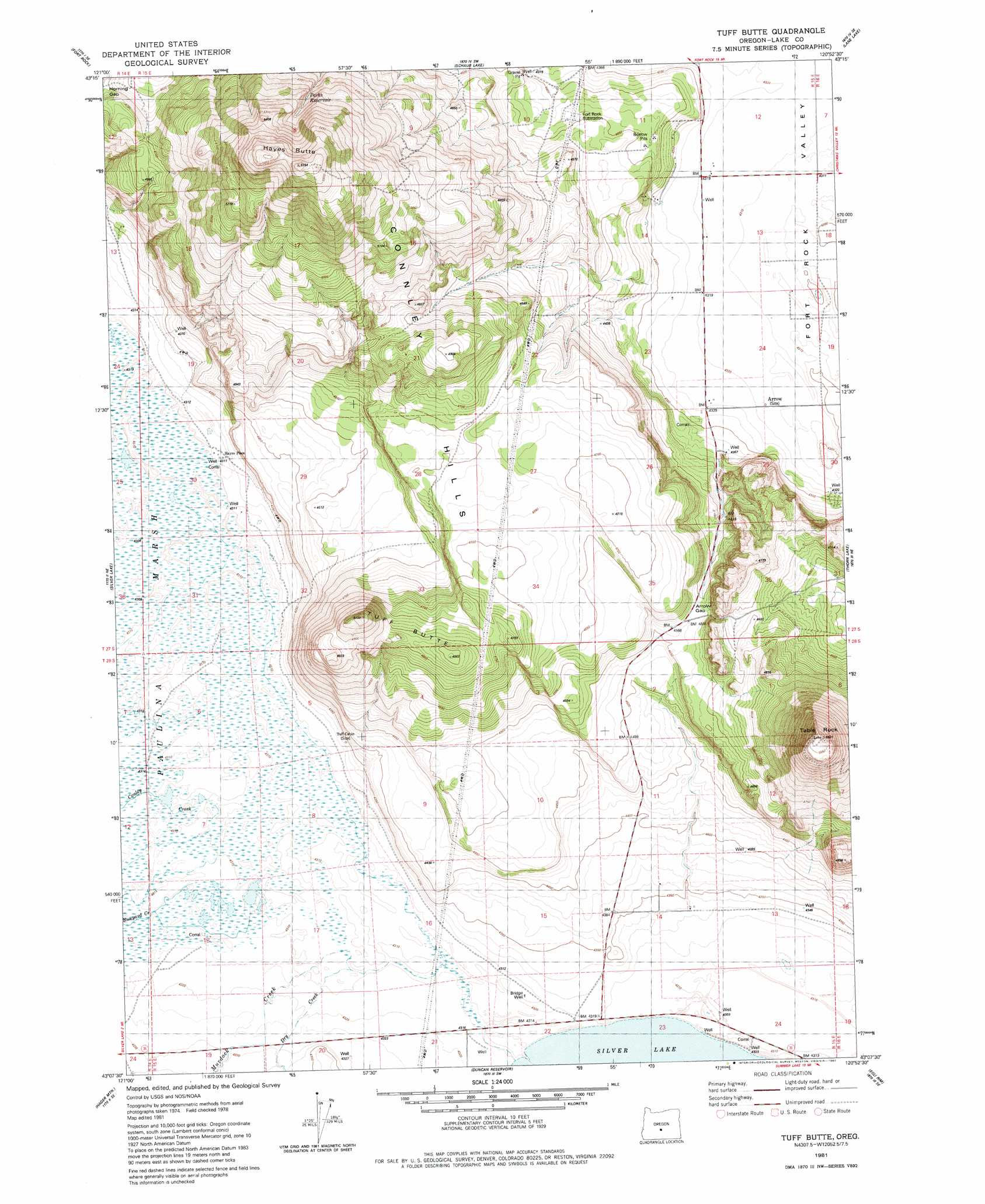
USGS Topo Quad 43120b8 - 1:24,000 scale
| Topo Map Name: | Tuff Butte |
| USGS Topo Quad ID: | 43120b8 |
| Print Size: | ca. 21 1/4" wide x 27" high |
| Southeast Coordinates: | 43.125° N latitude / 120.875° W longitude |
| Map Center Coordinates: | 43.1875° N latitude / 120.9375° W longitude |
| U.S. State: | OR |
| Filename: | o43120b8.jpg |
| Download Map JPG Image: | Tuff Butte topo map 1:24,000 scale |
| Map Type: | Topographic |
| Topo Series: | 7.5´ |
| Map Scale: | 1:24,000 |
| Source of Map Images: | United States Geological Survey (USGS) |
| Alternate Map Versions: |
Tuff Butte OR 1981, updated 1982 Download PDF Buy paper map Tuff Butte OR 2011 Download PDF Buy paper map Tuff Butte OR 2014 Download PDF Buy paper map |
1:24,000 Topo Quads surrounding Tuff Butte
Hole In The Ground |
Cabin Lake |
Cougar Mountain |
Hogback Butte |
Jacks Place |
Mccarty Butte |
Fort Rock |
Schaub Lake |
Lane Lake |
Crack In The Ground |
Oatman Flat |
Silver Lake |
Tuff Butte |
Thorn Lake |
Christmas Valley |
Bridge Creek Draw |
Hager Mountain |
Duncan Reservoir |
Egli Rim |
Sheeplick Draw |
Partin Butte |
Thompson Reservoir |
Foster Butte |
Summer Lake |
Ana River |
> Back to 43120a1 at 1:100,000 scale
> Back to 43120a1 at 1:250,000 scale
> Back to U.S. Topo Maps home
Tuff Butte topo map: Gazetteer
Tuff Butte: Gaps
Arrow Gap elevation 1393m 4570′Horning Gap elevation 1416m 4645′
Tuff Butte: Post Offices
Arrow Post Office (historical) elevation 1317m 4320′Tuff Butte: Reservoirs
Parks Reservoir elevation 1526m 5006′Tuff Butte: Streams
Bunyard Creek elevation 1315m 4314′Conley Creek elevation 1315m 4314′
Dry Creek elevation 1315m 4314′
Murdock Creek elevation 1315m 4314′
Silver Creek elevation 1315m 4314′
Tuff Butte: Summits
Hayes Butte elevation 1719m 5639′Table Rock elevation 1631m 5351′
Tuff Butte elevation 1550m 5085′
Tuff Butte: Wells
Bridge Well elevation 1317m 4320′Tuff Butte digital topo map on disk
Buy this Tuff Butte topo map showing relief, roads, GPS coordinates and other geographical features, as a high-resolution digital map file on DVD: