Pine Mountain Topo Map Oregon
To zoom in, hover over the map of Pine Mountain
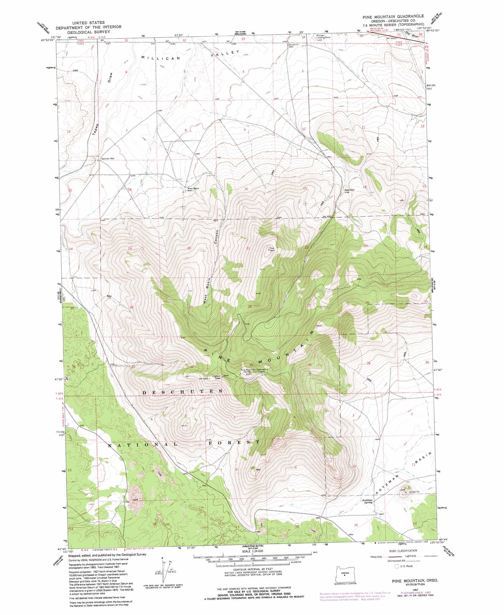
USGS Topo Quad 43120g8 - 1:24,000 scale
| Topo Map Name: | Pine Mountain |
| USGS Topo Quad ID: | 43120g8 |
| Print Size: | ca. 21 1/4" wide x 27" high |
| Southeast Coordinates: | 43.75° N latitude / 120.875° W longitude |
| Map Center Coordinates: | 43.8125° N latitude / 120.9375° W longitude |
| U.S. State: | OR |
| Filename: | o43120g8.jpg |
| Download Map JPG Image: | Pine Mountain topo map 1:24,000 scale |
| Map Type: | Topographic |
| Topo Series: | 7.5´ |
| Map Scale: | 1:24,000 |
| Source of Map Images: | United States Geological Survey (USGS) |
| Alternate Map Versions: |
Pine Mountain OR 1967, updated 1969 Download PDF Buy paper map Pine Mountain OR 1967, updated 1981 Download PDF Buy paper map Pine Mountain OR 1967, updated 1992 Download PDF Buy paper map Pine Mountain OR 2011 Download PDF Buy paper map Pine Mountain OR 2014 Download PDF Buy paper map |
| FStopo: | US Forest Service topo Pine Mountain is available: Download FStopo PDF Download FStopo TIF |
1:24,000 Topo Quads surrounding Pine Mountain
Bend Airport |
Alfalfa |
Horse Butte |
Bowman Dam |
Alkali Flat |
Kelsey Butte |
Horse Ridge |
Millican |
West Butte |
Rodman Ridge |
Fuzztail Butte |
Evans Well |
Pine Mountain |
Millican Se |
Brothers Sw |
East Lake |
China Hat |
Firestone Butte |
Plot Butte |
Dickerson Flat |
Indian Butte |
South Ice Cave |
Sixteen Butte |
Fox Butte |
Walker Butte |
> Back to 43120e1 at 1:100,000 scale
> Back to 43120a1 at 1:250,000 scale
> Back to U.S. Topo Maps home
Pine Mountain topo map: Gazetteer
Pine Mountain: Basins
Millican Valley elevation 1290m 4232′Pine Mountain: Post Offices
Whitaker Post Office (historical) elevation 1376m 4514′Pine Mountain: Springs
Antelope Spring elevation 1470m 4822′Pine Mountain: Summits
Pine Mountain elevation 1980m 6496′Pine Mountain: Valleys
West Basin Canyon elevation 1306m 4284′Pine Mountain: Wells
Bradetich Well elevation 1310m 4297′Deep Well elevation 1458m 4783′
Spencer Well elevation 1316m 4317′
West Basin Well elevation 1326m 4350′
Pine Mountain digital topo map on disk
Buy this Pine Mountain topo map showing relief, roads, GPS coordinates and other geographical features, as a high-resolution digital map file on DVD: