Bridge Creek Draw Topo Map Oregon
To zoom in, hover over the map of Bridge Creek Draw
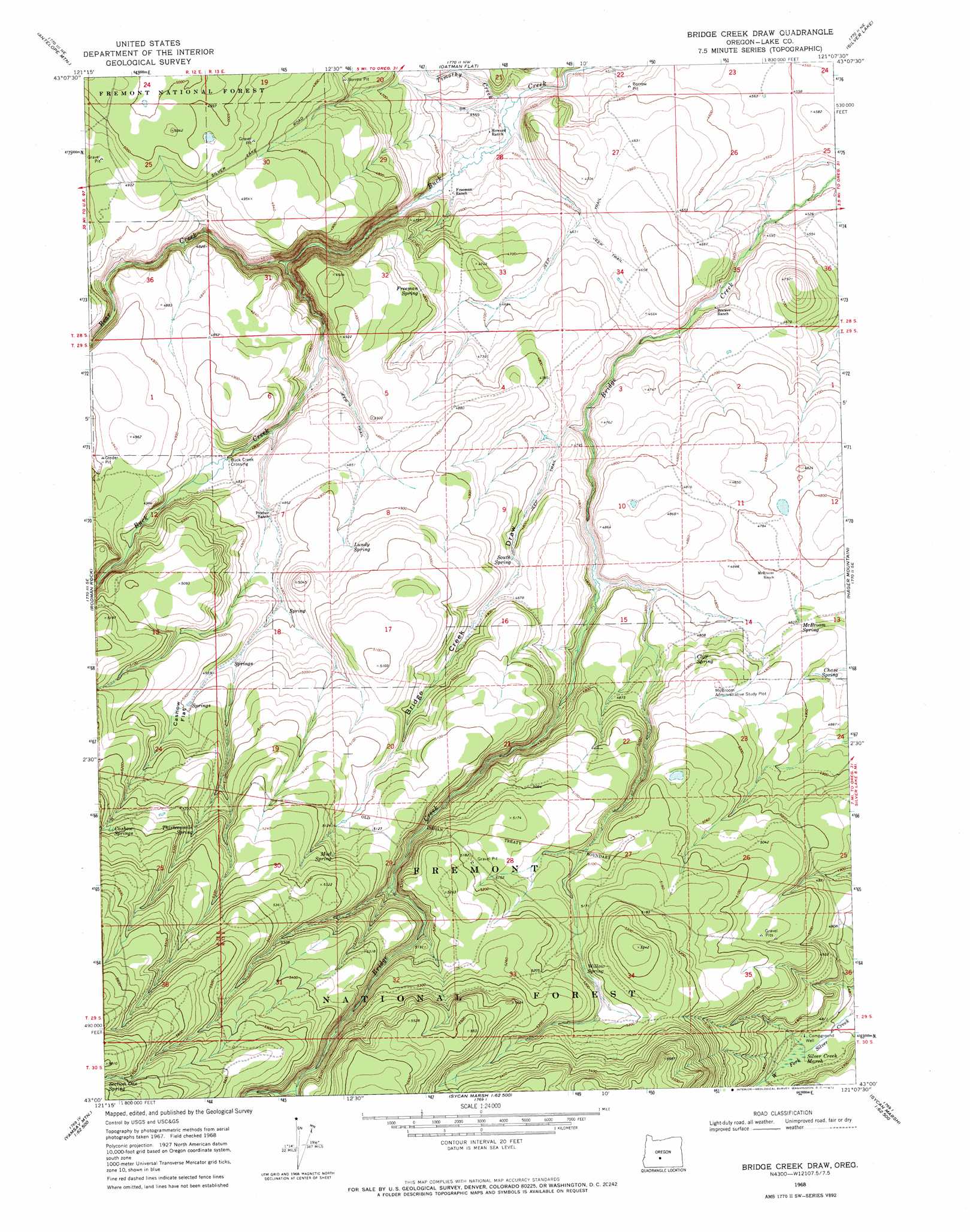
USGS Topo Quad 43121a2 - 1:24,000 scale
| Topo Map Name: | Bridge Creek Draw |
| USGS Topo Quad ID: | 43121a2 |
| Print Size: | ca. 21 1/4" wide x 27" high |
| Southeast Coordinates: | 43° N latitude / 121.125° W longitude |
| Map Center Coordinates: | 43.0625° N latitude / 121.1875° W longitude |
| U.S. State: | OR |
| Filename: | o43121a2.jpg |
| Download Map JPG Image: | Bridge Creek Draw topo map 1:24,000 scale |
| Map Type: | Topographic |
| Topo Series: | 7.5´ |
| Map Scale: | 1:24,000 |
| Source of Map Images: | United States Geological Survey (USGS) |
| Alternate Map Versions: |
Bridge Creek Draw OR 1968, updated 1972 Download PDF Buy paper map Bridge Creek Draw OR 1968, updated 1972 Download PDF Buy paper map Bridge Creek Draw OR 2004, updated 2007 Download PDF Buy paper map Bridge Creek Draw OR 2011 Download PDF Buy paper map Bridge Creek Draw OR 2014 Download PDF Buy paper map |
| FStopo: | US Forest Service topo Bridge Creek Draw is available: Download FStopo PDF Download FStopo TIF |
1:24,000 Topo Quads surrounding Bridge Creek Draw
Stams Mountain |
Wickiup Spring |
Mccarty Butte |
Fort Rock |
Schaub Lake |
Location Butte |
Antelope Mountain |
Oatman Flat |
Silver Lake |
Tuff Butte |
Bear Butte |
Rodman Rock |
Bridge Creek Draw |
Hager Mountain |
Duncan Reservoir |
Gordon Lake |
Yamsay Mountain |
Partin Butte |
Thompson Reservoir |
Foster Butte |
The Bull Pasture |
Hamelton Butte |
Sycan Marsh West |
Sycan Marsh East |
Pole Butte |
> Back to 43121a1 at 1:100,000 scale
> Back to 43120a1 at 1:250,000 scale
> Back to U.S. Topo Maps home
Bridge Creek Draw topo map: Gazetteer
Bridge Creek Draw: Flats
Cashow Flat elevation 1529m 5016′Bridge Creek Draw: Post Offices
Porterville Post Office (historical) elevation 1471m 4826′Bridge Creek Draw: Reservoirs
Basalt Reservoir elevation 1629m 5344′Bridge Creek Waterhole elevation 1452m 4763′
South Spring Reservoir elevation 1472m 4829′
Staked Waterhole elevation 1401m 4596′
Ted Reservoir elevation 1414m 4639′
Bridge Creek Draw: Springs
Cashow Springs elevation 1609m 5278′Chase Spring elevation 1477m 4845′
Cliff Spring elevation 1488m 4881′
Freeman Spring elevation 1472m 4829′
Lundy Spring elevation 1505m 4937′
McBroom Spring elevation 1474m 4835′
Mud Spring elevation 1576m 5170′
South Spring elevation 1476m 4842′
Thirteenmile Spring elevation 1579m 5180′
Willow Spring elevation 1569m 5147′
Bridge Creek Draw: Streams
Bear Creek elevation 1414m 4639′Timothy Creek elevation 1375m 4511′
Bridge Creek Draw: Swamps
Silver Creek Marsh elevation 1472m 4829′Bridge Creek Draw: Valleys
Bridge Creek Draw elevation 1424m 4671′Bridge Creek Draw digital topo map on disk
Buy this Bridge Creek Draw topo map showing relief, roads, GPS coordinates and other geographical features, as a high-resolution digital map file on DVD: