Sugarpine Mountain Nw Topo Map Oregon
To zoom in, hover over the map of Sugarpine Mountain Nw
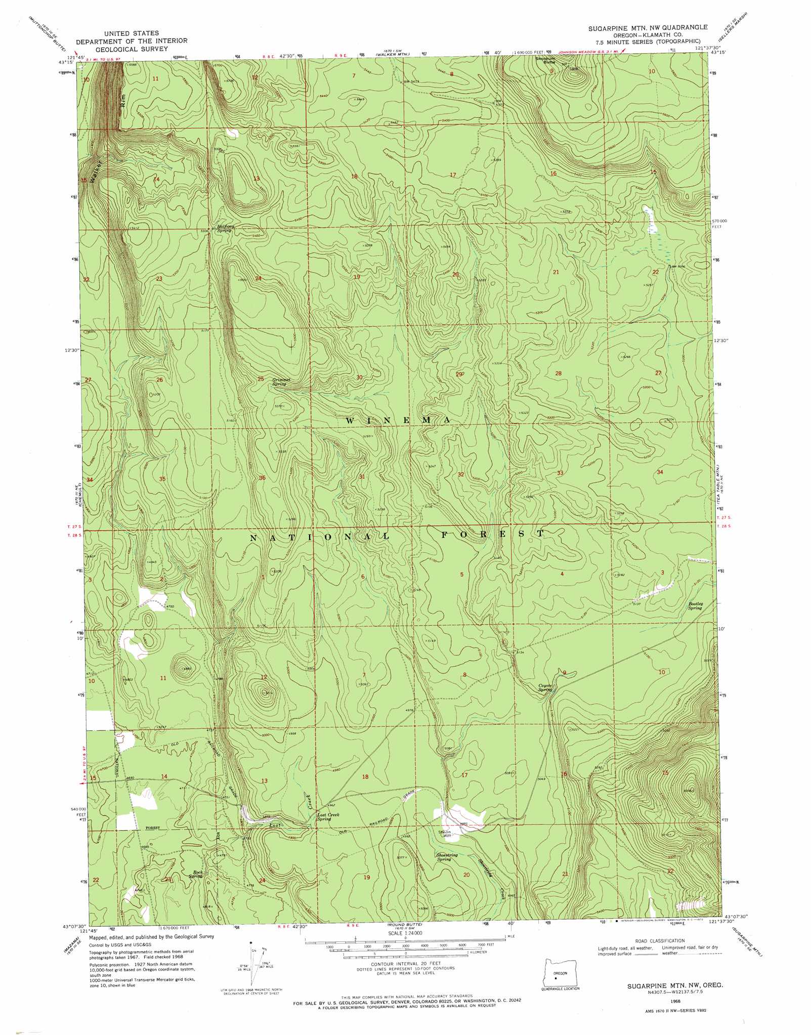
USGS Topo Quad 43121b6 - 1:24,000 scale
| Topo Map Name: | Sugarpine Mountain Nw |
| USGS Topo Quad ID: | 43121b6 |
| Print Size: | ca. 21 1/4" wide x 27" high |
| Southeast Coordinates: | 43.125° N latitude / 121.625° W longitude |
| Map Center Coordinates: | 43.1875° N latitude / 121.6875° W longitude |
| U.S. State: | OR |
| Filename: | o43121b6.jpg |
| Download Map JPG Image: | Sugarpine Mountain Nw topo map 1:24,000 scale |
| Map Type: | Topographic |
| Topo Series: | 7.5´ |
| Map Scale: | 1:24,000 |
| Source of Map Images: | United States Geological Survey (USGS) |
| Alternate Map Versions: |
Sugarpine Mtn. NW OR 1968, updated 1972 Download PDF Buy paper map Sugarpine Mountain NW OR 1999, updated 2002 Download PDF Buy paper map Sugarpine Mountain NW OR 2011 Download PDF Buy paper map Sugarpine Mountain NW OR 2014 Download PDF Buy paper map |
| FStopo: | US Forest Service topo Sugarpine Mountain NW is available: Download FStopo PDF Download FStopo TIF |
1:24,000 Topo Quads surrounding Sugarpine Mountain Nw
Crescent Lake |
Odell Butte |
Crescent |
Crescent Ne |
Grass Well |
Burn Butte |
Muttonchop Butte |
Walker Mountain |
Sellers Marsh |
Stams Mountain |
Miller Lake |
Chemult |
Sugarpine Mountain Nw |
Tea Table Mountain |
Location Butte |
Welch Butte |
Mazama |
Round Butte |
Sugarpine Mountain |
Bear Butte |
Pothole Butte |
Lenz |
Military Crossing |
Wildhorse Ridge |
Gordon Lake |
> Back to 43121a1 at 1:100,000 scale
> Back to 43120a1 at 1:250,000 scale
> Back to U.S. Topo Maps home
Sugarpine Mountain Nw topo map: Gazetteer
Sugarpine Mountain Nw: Post Offices
Shevlin Post Office (historical) elevation 1524m 5000′Sugarpine Mountain Nw: Springs
Bootleg Spring elevation 1562m 5124′Coyote Spring elevation 1557m 5108′
Grimmet Spring elevation 1620m 5314′
Halfway Spring elevation 1628m 5341′
Lost Creek Spring elevation 1505m 4937′
Rock Spring elevation 1448m 4750′
Shoestring Spring elevation 1513m 4963′
Sugarpine Mountain Nw: Streams
Lost Creek elevation 1446m 4744′Sugarpine Mountain Nw: Wells
Shevlin Well elevation 1519m 4983′Sugarpine Mountain Nw digital topo map on disk
Buy this Sugarpine Mountain Nw topo map showing relief, roads, GPS coordinates and other geographical features, as a high-resolution digital map file on DVD: