Wickiup Dam Topo Map Oregon
To zoom in, hover over the map of Wickiup Dam
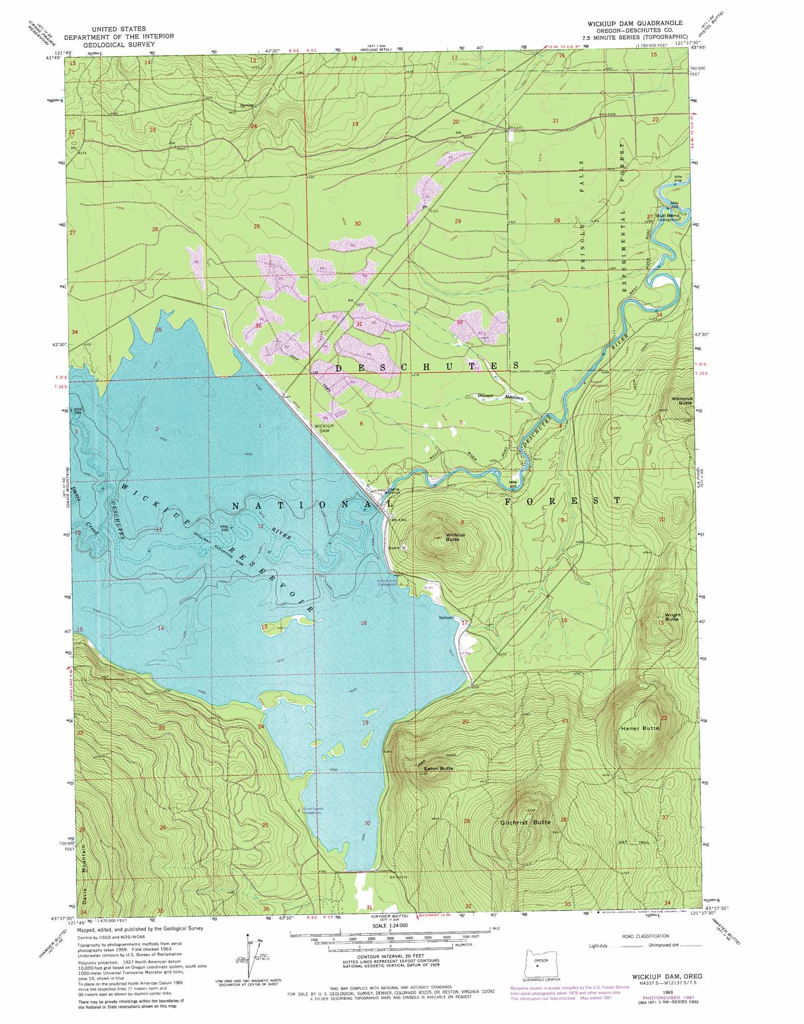
USGS Topo Quad 43121f6 - 1:24,000 scale
| Topo Map Name: | Wickiup Dam |
| USGS Topo Quad ID: | 43121f6 |
| Print Size: | ca. 21 1/4" wide x 27" high |
| Southeast Coordinates: | 43.625° N latitude / 121.625° W longitude |
| Map Center Coordinates: | 43.6875° N latitude / 121.6875° W longitude |
| U.S. State: | OR |
| Filename: | o43121f6.jpg |
| Download Map JPG Image: | Wickiup Dam topo map 1:24,000 scale |
| Map Type: | Topographic |
| Topo Series: | 7.5´ |
| Map Scale: | 1:24,000 |
| Source of Map Images: | United States Geological Survey (USGS) |
| Alternate Map Versions: |
Wickiup Dam OR 1963, updated 1965 Download PDF Buy paper map Wickiup Dam OR 1963, updated 1978 Download PDF Buy paper map Wickiup Dam OR 1963, updated 1982 Download PDF Buy paper map Wickiup Dam OR 2011 Download PDF Buy paper map Wickiup Dam OR 2014 Download PDF Buy paper map |
| FStopo: | US Forest Service topo Wickiup Dam is available: Download FStopo PDF Download FStopo TIF |
1:24,000 Topo Quads surrounding Wickiup Dam
Packsaddle Mountain |
Elk Lake |
Bachelor Butte |
Wanoga Butte |
Benham Falls |
Irish Mountain |
Crane Prairie Reservoir |
Round Mountain |
Pistol Butte |
Anns Butte |
The Twins |
Davis Mountain |
Wickiup Dam |
La Pine |
Finley Butte |
Odell Lake |
Hamner Butte |
Cryder Butte |
Masten Butte |
Moffitt Butte |
Crescent Lake |
Odell Butte |
Crescent |
Crescent Ne |
Grass Well |
> Back to 43121e1 at 1:100,000 scale
> Back to 43120a1 at 1:250,000 scale
> Back to U.S. Topo Maps home
Wickiup Dam topo map: Gazetteer
Wickiup Dam: Bends
Bull Bend elevation 1301m 4268′Wickiup Dam: Dams
Wickiup Dam elevation 1323m 4340′Wickiup Dam: Forests
Pringle Falls Experimental Forest elevation 1312m 4304′Wickiup Dam: Lakes
Stagnant Lake elevation 1322m 4337′Wickiup Dam: Parks
Pringle Falls Research Natural Area elevation 1331m 4366′Wickiup Dam: Reservoirs
Wickiup Reservoir elevation 1323m 4340′Wickiup Dam: Streams
Davis Creek elevation 1323m 4340′Wickiup Dam: Summits
Eaton Butte elevation 1573m 5160′Gilchrist Butte elevation 1685m 5528′
Haner Butte elevation 1550m 5085′
Wickiup Butte elevation 1487m 4878′
Wright Butte elevation 1458m 4783′
Wickiup Dam: Swamps
Dilman Meadows elevation 1309m 4294′Wickiup Dam digital topo map on disk
Buy this Wickiup Dam topo map showing relief, roads, GPS coordinates and other geographical features, as a high-resolution digital map file on DVD: