The Twins Topo Map Oregon
To zoom in, hover over the map of The Twins
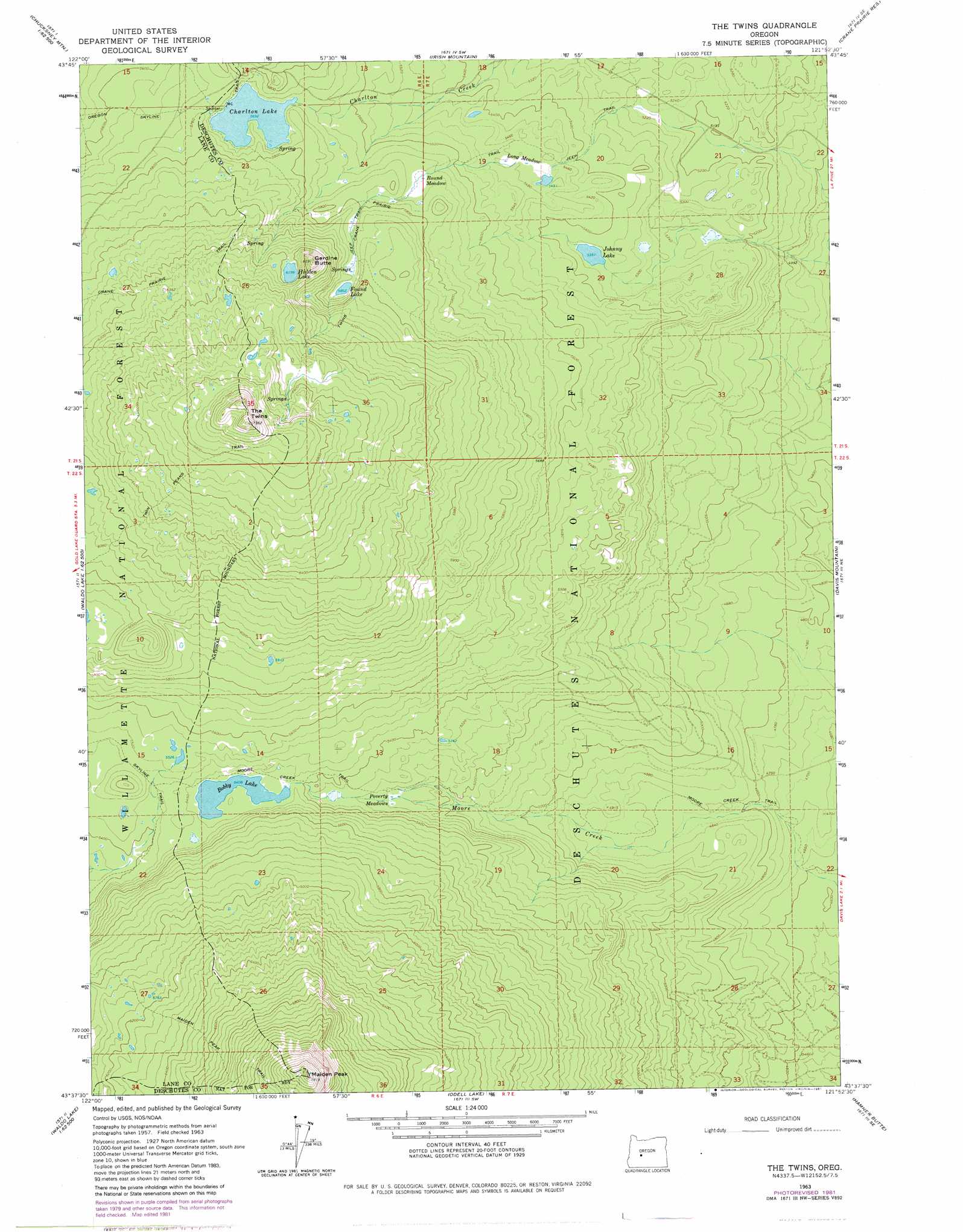
USGS Topo Quad 43121f8 - 1:24,000 scale
| Topo Map Name: | The Twins |
| USGS Topo Quad ID: | 43121f8 |
| Print Size: | ca. 21 1/4" wide x 27" high |
| Southeast Coordinates: | 43.625° N latitude / 121.875° W longitude |
| Map Center Coordinates: | 43.6875° N latitude / 121.9375° W longitude |
| U.S. State: | OR |
| Filename: | o43121f8.jpg |
| Download Map JPG Image: | The Twins topo map 1:24,000 scale |
| Map Type: | Topographic |
| Topo Series: | 7.5´ |
| Map Scale: | 1:24,000 |
| Source of Map Images: | United States Geological Survey (USGS) |
| Alternate Map Versions: |
The Twins OR 1963, updated 1965 Download PDF Buy paper map The Twins OR 1963, updated 1972 Download PDF Buy paper map The Twins OR 1963, updated 1981 Download PDF Buy paper map The Twins OR 1963, updated 1981 Download PDF Buy paper map The Twins OR 1997, updated 2001 Download PDF Buy paper map The Twins OR 2011 Download PDF Buy paper map The Twins OR 2014 Download PDF Buy paper map |
| FStopo: | US Forest Service topo The Twins is available: Download FStopo PDF Download FStopo TIF |
1:24,000 Topo Quads surrounding The Twins
Grasshopper Mountain |
Chucksney Mountain |
Packsaddle Mountain |
Elk Lake |
Bachelor Butte |
Blair Lake |
Waldo Mountain |
Irish Mountain |
Crane Prairie Reservoir |
Round Mountain |
Mount David Douglas |
Waldo Lake |
The Twins |
Davis Mountain |
Wickiup Dam |
Diamond Peak |
Willamette Pass |
Odell Lake |
Hamner Butte |
Cryder Butte |
Emigrant Butte |
Cowhorn Mountain |
Crescent Lake |
Odell Butte |
Crescent |
> Back to 43121e1 at 1:100,000 scale
> Back to 43120a1 at 1:250,000 scale
> Back to U.S. Topo Maps home
The Twins topo map: Gazetteer
The Twins: Flats
Long Meadow elevation 1671m 5482′The Twins: Lakes
Barren Lake elevation 2006m 6581′Bobby Lake elevation 1650m 5413′
Charlton Lake elevation 1736m 5695′
Found Lake elevation 1790m 5872′
Gerdine Lake elevation 1887m 6190′
Grouse Lake elevation 1893m 6210′
Hidden Lake elevation 1888m 6194′
Johnny Lake elevation 1632m 5354′
The Twins: Summits
Gerdine Butte elevation 1979m 6492′Maiden Peak elevation 2379m 7805′
The Twins elevation 2231m 7319′
The Twins: Swamps
Poverty Meadows elevation 1609m 5278′Round Meadow elevation 1742m 5715′
The Twins: Trails
Moore Creek Trail elevation 1482m 4862′Twin Peaks Trail elevation 1884m 6181′
The Twins digital topo map on disk
Buy this The Twins topo map showing relief, roads, GPS coordinates and other geographical features, as a high-resolution digital map file on DVD: