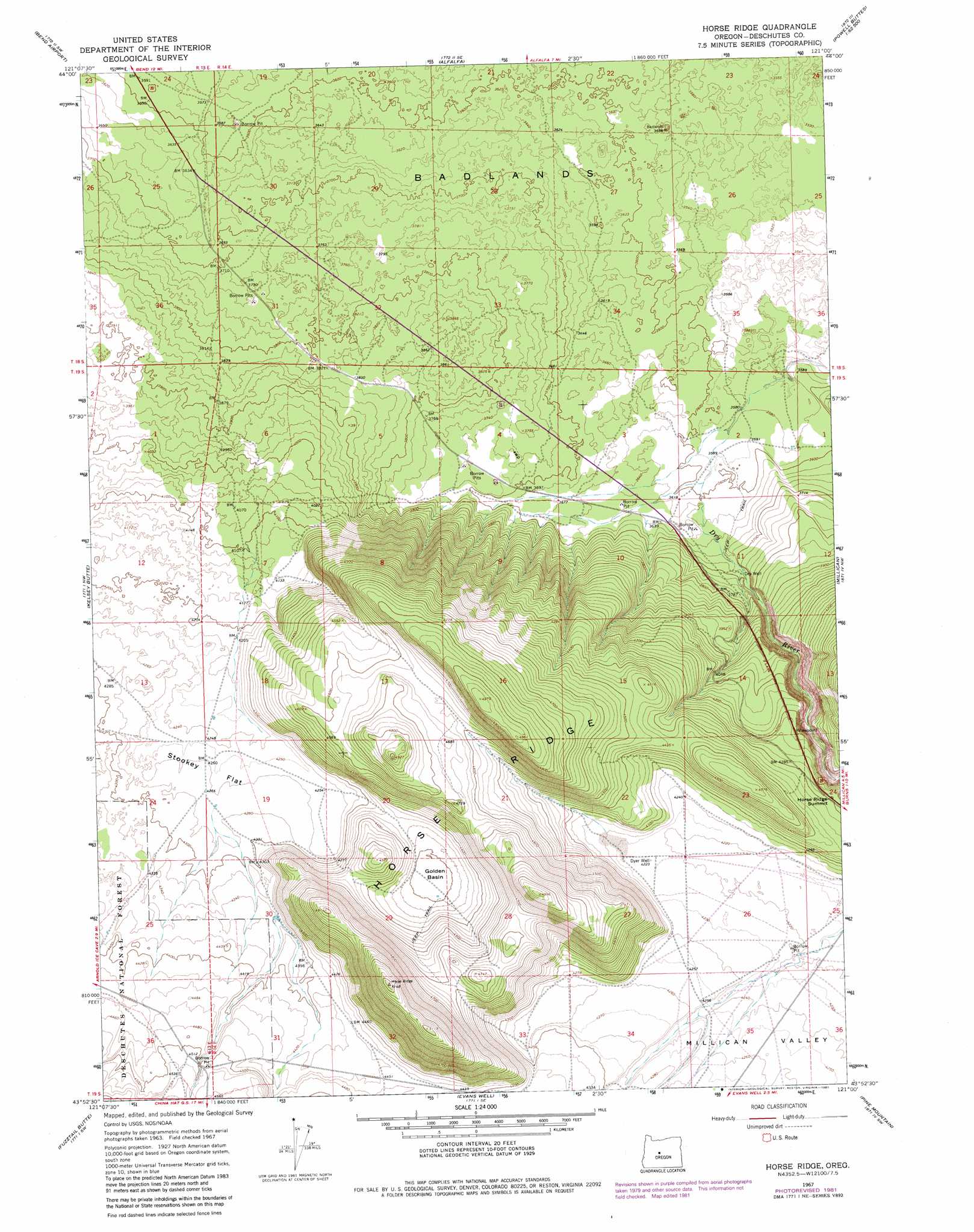
Horse Ridge Topo Map Oregon
To zoom in, hover over the map of Horse Ridge
USGS Topo Quad 43121h1 - 1:24,000 scale
| Topo Map Name: | Horse Ridge |
| USGS Topo Quad ID: | 43121h1 |
| Print Size: | ca. 21 1/4" wide x 27" high |
| Southeast Coordinates: | 43.875° N latitude / 121° W longitude |
| Map Center Coordinates: | 43.9375° N latitude / 121.0625° W longitude |
| U.S. State: | OR |
| Filename: | o43121h1.jpg |
| Download Map JPG Image: | Horse Ridge topo map 1:24,000 scale |
| Map Type: | Topographic |
| Topo Series: | 7.5´ |
| Map Scale: | 1:24,000 |
| Source of Map Images: | United States Geological Survey (USGS) |
| Alternate Map Versions: |
Horse Ridge OR 1967, updated 1969 Download PDF Buy paper map Horse Ridge OR 1967, updated 1981 Download PDF Buy paper map Horse Ridge OR 1967, updated 1981 Download PDF Buy paper map Horse Ridge OR 2011 Download PDF Buy paper map Horse Ridge OR 2014 Download PDF Buy paper map |
| FStopo: | US Forest Service topo Horse Ridge is available: Download FStopo PDF Download FStopo TIF |
1:24,000 Topo Quads surrounding Horse Ridge
Tumalo |
Forked Horn Butte |
Powell Butte |
Powell Buttes |
Stearns Butte |
Bend |
Bend Airport |
Alfalfa |
Horse Butte |
Bowman Dam |
Lava Butte |
Kelsey Butte |
Horse Ridge |
Millican |
West Butte |
Lava Cast Forest |
Fuzztail Butte |
Evans Well |
Pine Mountain |
Millican Se |
Paulina Peak |
East Lake |
China Hat |
Firestone Butte |
Plot Butte |
> Back to 43121e1 at 1:100,000 scale
> Back to 43120a1 at 1:250,000 scale
> Back to U.S. Topo Maps home
Horse Ridge topo map: Gazetteer
Horse Ridge: Areas
Badlands elevation 1123m 3684′Horse Ridge: Basins
Golden Basin elevation 1307m 4288′Horse Ridge: Flats
Stookey Flat elevation 1300m 4265′Horse Ridge: Gaps
Horse Ridge Summit elevation 1308m 4291′Horse Ridge: Parks
Horse Ridge Natural Area elevation 1371m 4498′Horse Ridge: Ridges
Horse Ridge elevation 1428m 4685′Horse Ridge: Wells
Dyer Well elevation 1289m 4229′Horse Ridge digital topo map on disk
Buy this Horse Ridge topo map showing relief, roads, GPS coordinates and other geographical features, as a high-resolution digital map file on DVD: