Hamaker Butte Topo Map Oregon
To zoom in, hover over the map of Hamaker Butte
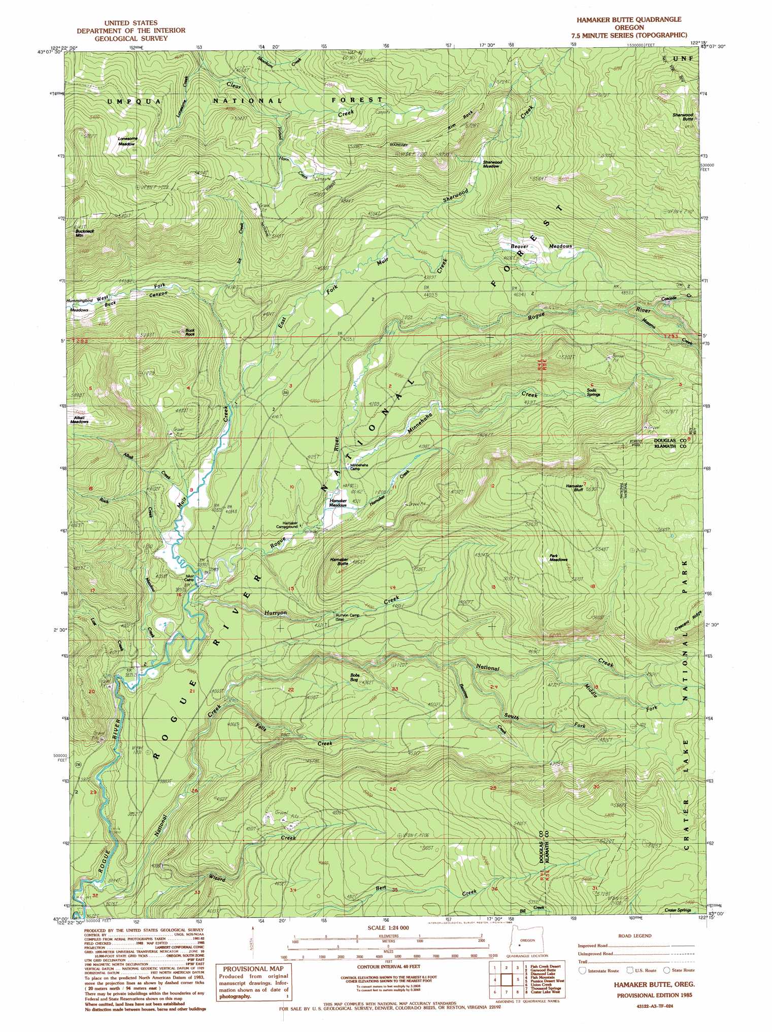
USGS Topo Quad 43122a3 - 1:24,000 scale
| Topo Map Name: | Hamaker Butte |
| USGS Topo Quad ID: | 43122a3 |
| Print Size: | ca. 21 1/4" wide x 27" high |
| Southeast Coordinates: | 43° N latitude / 122.25° W longitude |
| Map Center Coordinates: | 43.0625° N latitude / 122.3125° W longitude |
| U.S. State: | OR |
| Filename: | o43122a3.jpg |
| Download Map JPG Image: | Hamaker Butte topo map 1:24,000 scale |
| Map Type: | Topographic |
| Topo Series: | 7.5´ |
| Map Scale: | 1:24,000 |
| Source of Map Images: | United States Geological Survey (USGS) |
| Alternate Map Versions: |
Hamaker Butte OR 1985, updated 1985 Download PDF Buy paper map Hamaker Butte OR 1997, updated 2000 Download PDF Buy paper map Hamaker Butte OR 2011 Download PDF Buy paper map Hamaker Butte OR 2014 Download PDF Buy paper map |
| FStopo: | US Forest Service topo Hamaker Butte is available: Download FStopo PDF Download FStopo TIF |
1:24,000 Topo Quads surrounding Hamaker Butte
Illahee Rock |
Toketee Falls |
Potter Mountain |
Lemolo Lake |
Tolo Mountain |
Twin Lakes Mountain |
Fish Creek Desert |
Garwood Butte |
Diamond Lake |
Mount Thielsen |
Buckeye Lake |
Fish Mountain |
Hamaker Butte |
Pumice Desert West |
Pumice Desert East |
Abbott Butte |
Union Creek |
Thousand Springs |
Crater Lake West |
Crater Lake East |
Whetstone Point |
Prospect North |
Red Blanket Mountain |
Union Peak |
Maklaks Crater |
> Back to 43122a1 at 1:100,000 scale
> Back to 43122a1 at 1:250,000 scale
> Back to U.S. Topo Maps home
Hamaker Butte topo map: Gazetteer
Hamaker Butte: Cliffs
Hamaker Bluff elevation 1668m 5472′Hamaker Butte: Falls
Muir Creek Falls elevation 1210m 3969′Hamaker Butte: Flats
Beaver Meadows elevation 1454m 4770′Hamaker Meadows elevation 1222m 4009′
Lonesome Meadow elevation 1590m 5216′
Park Meadows elevation 1612m 5288′
Rock Meadow elevation 1217m 3992′
Sherwood Meadow elevation 1487m 4878′
Hamaker Butte: Parks
Buck Camp elevation 1507m 4944′Clear Creek Camp elevation 1613m 5291′
Hurryon Camp elevation 1321m 4333′
Hamaker Butte: Pillars
Buck Rock elevation 1509m 4950′Rim Rock elevation 1743m 5718′
Hamaker Butte: Ridges
Crescent Ridge elevation 1791m 5875′Minnehaha Ridge elevation 1570m 5150′
Razor Ridge elevation 1426m 4678′
Hamaker Butte: Springs
Soda Spring elevation 1333m 4373′Hamaker Butte: Streams
Alkali Creek elevation 1202m 3943′Beartree Creek elevation 1315m 4314′
Cascade Creek elevation 1447m 4747′
East Fork Muir Creek elevation 1230m 4035′
Falls Creek elevation 1170m 3838′
Hamaker Creek elevation 1231m 4038′
Hurryon Creek elevation 1183m 3881′
Ice Creek elevation 1283m 4209′
Lonesome Creek elevation 1357m 4452′
Lost Creek elevation 1162m 3812′
Mazama Creek elevation 1439m 4721′
Meadow Creek elevation 1172m 3845′
Middle Fork National Creek elevation 1386m 4547′
Minnehaha Creek elevation 1234m 4048′
Muir Creek elevation 1187m 3894′
National Creek elevation 1103m 3618′
Rock Creek elevation 1199m 3933′
Sherwood Creek elevation 1317m 4320′
South Fork National Creek elevation 1327m 4353′
West Fork Muir Creek elevation 1282m 4206′
Hamaker Butte: Summits
Buckneck Mountain elevation 1865m 6118′Hamaker Butte elevation 1478m 4849′
Sherwood Butte elevation 2097m 6879′
Hamaker Butte: Swamps
Bobs Bay elevation 1264m 4146′Hamaker Butte: Trails
Beaver Meadows Trail elevation 1479m 4852′Minnehaha-Hurryon Trail elevation 1508m 4947′
Rim Rock Trail elevation 1445m 4740′
Three Lakes Trail elevation 1408m 4619′
Hamaker Butte: Valleys
Buck Canyon elevation 1323m 4340′Hamaker Butte digital topo map on disk
Buy this Hamaker Butte topo map showing relief, roads, GPS coordinates and other geographical features, as a high-resolution digital map file on DVD: