Rigdon Point Topo Map Oregon
To zoom in, hover over the map of Rigdon Point
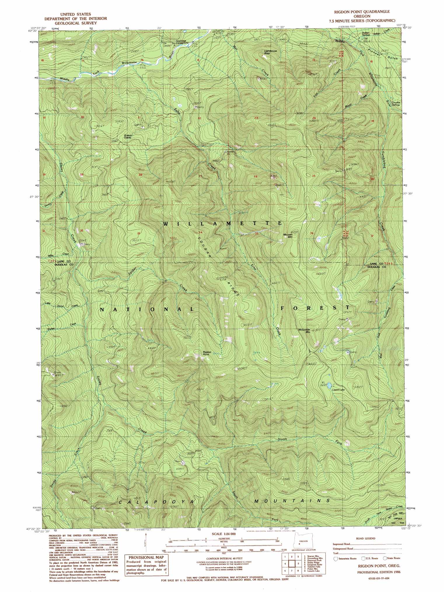
USGS Topo Quad 43122d3 - 1:24,000 scale
| Topo Map Name: | Rigdon Point |
| USGS Topo Quad ID: | 43122d3 |
| Print Size: | ca. 21 1/4" wide x 27" high |
| Southeast Coordinates: | 43.375° N latitude / 122.25° W longitude |
| Map Center Coordinates: | 43.4375° N latitude / 122.3125° W longitude |
| U.S. State: | OR |
| Filename: | o43122d3.jpg |
| Download Map JPG Image: | Rigdon Point topo map 1:24,000 scale |
| Map Type: | Topographic |
| Topo Series: | 7.5´ |
| Map Scale: | 1:24,000 |
| Source of Map Images: | United States Geological Survey (USGS) |
| Alternate Map Versions: |
Rigdon Point OR 1986, updated 1986 Download PDF Buy paper map Rigdon Point OR 1997, updated 1998 Download PDF Buy paper map Rigdon Point OR 2011 Download PDF Buy paper map Rigdon Point OR 2014 Download PDF Buy paper map |
| FStopo: | US Forest Service topo Rigdon Point is available: Download FStopo PDF Download FStopo TIF |
1:24,000 Topo Quads surrounding Rigdon Point
Holland Point |
Oakridge |
Mccredie Springs |
Mount David Douglas |
Waldo Lake |
Bearbones Mountain |
Warner Mountain |
Groundhog Mountain |
Diamond Peak |
Willamette Pass |
Reynolds Ridge |
Staley Ridge |
Rigdon Point |
Emigrant Butte |
Cowhorn Mountain |
Illahee Rock |
Toketee Falls |
Potter Mountain |
Lemolo Lake |
Tolo Mountain |
Twin Lakes Mountain |
Fish Creek Desert |
Garwood Butte |
Diamond Lake |
Mount Thielsen |
> Back to 43122a1 at 1:100,000 scale
> Back to 43122a1 at 1:250,000 scale
> Back to U.S. Topo Maps home
Rigdon Point topo map: Gazetteer
Rigdon Point: Flats
Grassy Glade elevation 1000m 3280′Rigdon Meadows elevation 749m 2457′
Rigdon Point: Lakes
Lizard Lake elevation 1719m 5639′Rigdon Point: Pillars
Lighthouse Rock elevation 1089m 3572′Rigdon Point: Ridges
Cougar Ridge elevation 1699m 5574′Rigdon Point: Springs
Chuckle Springs elevation 919m 3015′Indigo Springs elevation 864m 2834′
Rigdon Point: Streams
Davey Creek elevation 905m 2969′Dome Creek elevation 825m 2706′
Echo Creek elevation 699m 2293′
Fizz Creek elevation 825m 2706′
Indigo Creek elevation 860m 2821′
Little Dome Creek elevation 808m 2650′
Millie Creek elevation 766m 2513′
North Fork Staley Creek elevation 1124m 3687′
Royal Creek elevation 850m 2788′
Shelter Creek elevation 830m 2723′
South Fork Staley Creek elevation 1113m 3651′
Spider Creek elevation 857m 2811′
Tumblebug Creek elevation 873m 2864′
West Fork Tumblebug Creek elevation 1171m 3841′
Rigdon Point: Summits
McGowan Mountain elevation 1870m 6135′McLean Mountain elevation 1828m 5997′
Rigdon Point elevation 1827m 5994′
Rigdon Point: Trails
Echo Creek Trail elevation 1675m 5495′Old Burn Way elevation 1070m 3510′
Tumblebug Way elevation 1727m 5666′
Rigdon Point: Valleys
Pioneer Gulch elevation 854m 2801′Rigdon Point digital topo map on disk
Buy this Rigdon Point topo map showing relief, roads, GPS coordinates and other geographical features, as a high-resolution digital map file on DVD: