Chilcoot Mountain Topo Map Oregon
To zoom in, hover over the map of Chilcoot Mountain
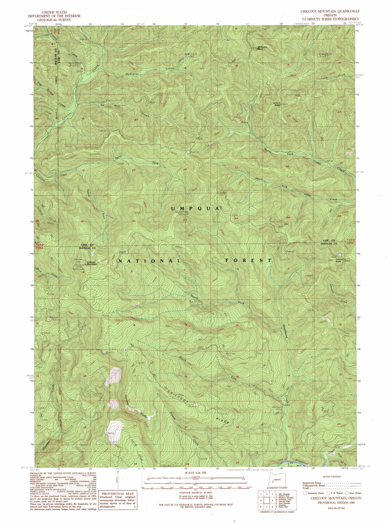
USGS Topo Quad 43122d6 - 1:24,000 scale
| Topo Map Name: | Chilcoot Mountain |
| USGS Topo Quad ID: | 43122d6 |
| Print Size: | ca. 21 1/4" wide x 27" high |
| Southeast Coordinates: | 43.375° N latitude / 122.625° W longitude |
| Map Center Coordinates: | 43.4375° N latitude / 122.6875° W longitude |
| U.S. State: | OR |
| Filename: | o43122d6.jpg |
| Download Map JPG Image: | Chilcoot Mountain topo map 1:24,000 scale |
| Map Type: | Topographic |
| Topo Series: | 7.5´ |
| Map Scale: | 1:24,000 |
| Source of Map Images: | United States Geological Survey (USGS) |
| Alternate Map Versions: |
Chilcoot Mountain OR 1989, updated 1990 Download PDF Buy paper map Chilcoot Mountain OR 1998, updated 2000 Download PDF Buy paper map Chilcoot Mountain OR 2011 Download PDF Buy paper map Chilcoot Mountain OR 2014 Download PDF Buy paper map |
| FStopo: | US Forest Service topo Chilcoot Mountain is available: Download FStopo PDF Download FStopo TIF |
1:24,000 Topo Quads surrounding Chilcoot Mountain
Blue Mountain |
Culp Creek |
Rose Hill |
Holland Point |
Oakridge |
Burnt Mountain |
Silica Mountain |
Fairview Peak |
Bearbones Mountain |
Warner Mountain |
Harrington Creek |
Scaredman Creek |
Chilcoot Mountain |
Reynolds Ridge |
Staley Ridge |
Old Fairview |
Mace Mountain |
Steamboat |
Illahee Rock |
Toketee Falls |
Red Butte |
Taft Mountain |
Quartz Mountain |
Twin Lakes Mountain |
Fish Creek Desert |
> Back to 43122a1 at 1:100,000 scale
> Back to 43122a1 at 1:250,000 scale
> Back to U.S. Topo Maps home
Chilcoot Mountain topo map: Gazetteer
Chilcoot Mountain: Cliffs
Hipower Bluffs elevation 1197m 3927′Chilcoot Mountain: Pillars
McKinley Rock elevation 1117m 3664′Chilcoot Mountain: Ridges
Chilcoot Ridge elevation 1010m 3313′President Ridge elevation 959m 3146′
Chilcoot Mountain: Springs
Three Springs elevation 931m 3054′Chilcoot Mountain: Streams
Francis Creek elevation 642m 2106′Lost Bucket Creek elevation 619m 2030′
McKinley Creek elevation 660m 2165′
No Man Creek elevation 622m 2040′
North Fork Chilcoot Creek elevation 728m 2388′
North Fork Steelhead Creek elevation 589m 1932′
Singe Creek elevation 462m 1515′
South Fork Chilcoot Creek elevation 732m 2401′
South Fork Steelhead Creek elevation 527m 1729′
Chilcoot Mountain: Summits
Chilcoot Mountain elevation 1470m 4822′Johnson Butte elevation 986m 3234′
Lemon Butte elevation 1077m 3533′
Chilcoot Mountain: Trails
Chilcoot Trail elevation 1038m 3405′Johnson Trail elevation 1034m 3392′
Chilcoot Mountain digital topo map on disk
Buy this Chilcoot Mountain topo map showing relief, roads, GPS coordinates and other geographical features, as a high-resolution digital map file on DVD: