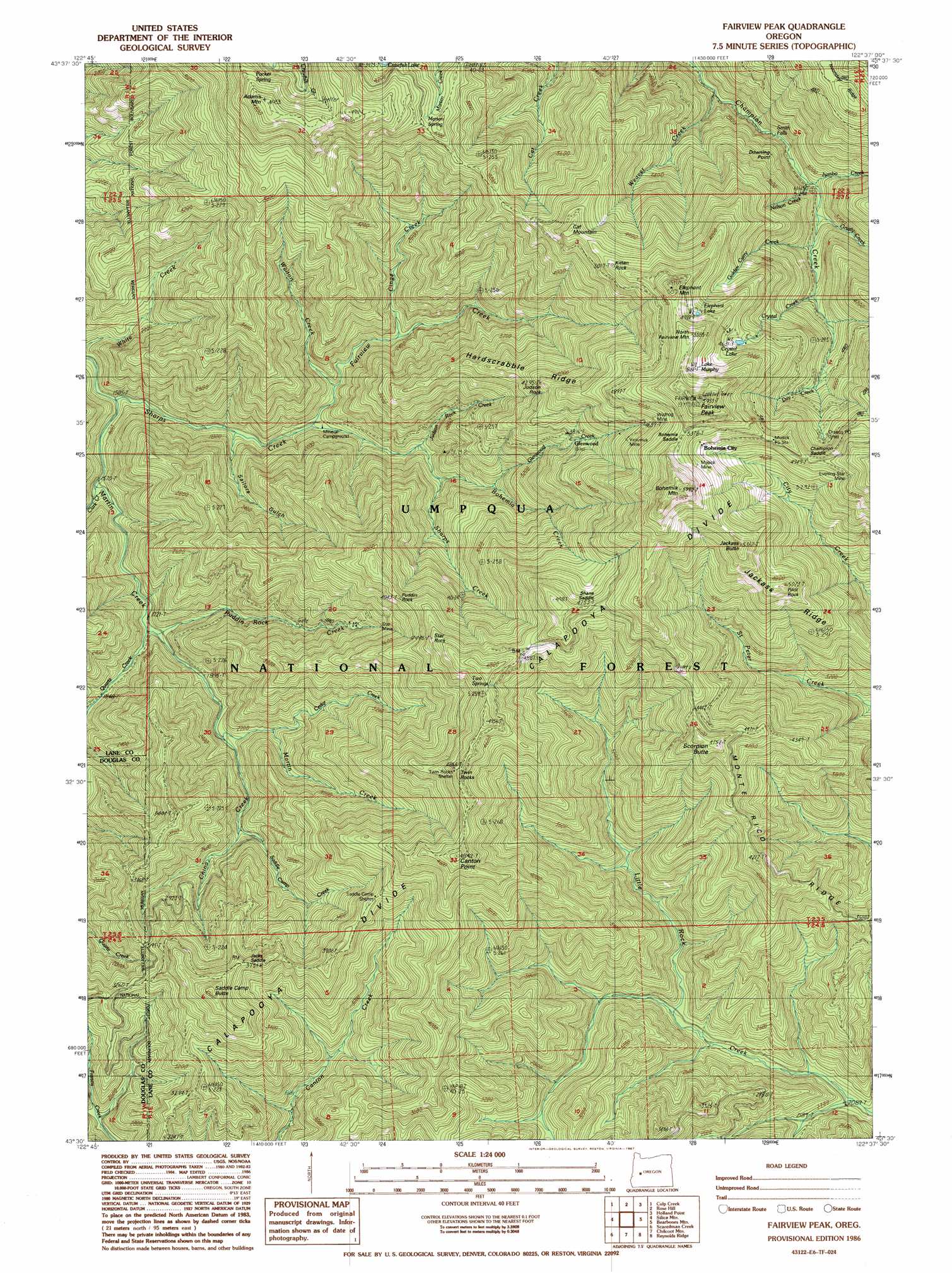
Fairview Peak Topo Map Oregon
To zoom in, hover over the map of Fairview Peak
USGS Topo Quad 43122e6 - 1:24,000 scale
| Topo Map Name: | Fairview Peak |
| USGS Topo Quad ID: | 43122e6 |
| Print Size: | ca. 21 1/4" wide x 27" high |
| Southeast Coordinates: | 43.5° N latitude / 122.625° W longitude |
| Map Center Coordinates: | 43.5625° N latitude / 122.6875° W longitude |
| U.S. State: | OR |
| Filename: | o43122e6.jpg |
| Download Map JPG Image: | Fairview Peak topo map 1:24,000 scale |
| Map Type: | Topographic |
| Topo Series: | 7.5´ |
| Map Scale: | 1:24,000 |
| Source of Map Images: | United States Geological Survey (USGS) |
| Alternate Map Versions: |
Fairview Peak OR 1986, updated 1987 Download PDF Buy paper map Fairview Peak OR 1997, updated 2000 Download PDF Buy paper map Fairview Peak OR 2011 Download PDF Buy paper map Fairview Peak OR 2014 Download PDF Buy paper map |
| FStopo: | US Forest Service topo Fairview Peak is available: Download FStopo PDF Download FStopo TIF |
1:24,000 Topo Quads surrounding Fairview Peak
Dorena Lake |
Kloster Mountain |
Mount June |
Westfir West |
Westfir East |
Blue Mountain |
Culp Creek |
Rose Hill |
Holland Point |
Oakridge |
Burnt Mountain |
Silica Mountain |
Fairview Peak |
Bearbones Mountain |
Warner Mountain |
Harrington Creek |
Scaredman Creek |
Chilcoot Mountain |
Reynolds Ridge |
Staley Ridge |
Old Fairview |
Mace Mountain |
Steamboat |
Illahee Rock |
Toketee Falls |
> Back to 43122e1 at 1:100,000 scale
> Back to 43122a1 at 1:250,000 scale
> Back to U.S. Topo Maps home
Fairview Peak topo map: Gazetteer
Fairview Peak: Basins
Crystal Basin elevation 1401m 4596′Fairview Peak: Falls
Smith Falls elevation 788m 2585′Fairview Peak: Gaps
Bohemia Saddle elevation 1643m 5390′Champion Saddle elevation 1511m 4957′
Jacks Saddle elevation 1091m 3579′
Shane Saddle elevation 1446m 4744′
Utopian Saddle elevation 1114m 3654′
Fairview Peak: Lakes
Crystal Lake elevation 1414m 4639′Elephant Lake elevation 1526m 5006′
Lake Murphy elevation 1583m 5193′
Fairview Peak: Mines
Champion Mine elevation 1315m 4314′Evening Star Mine elevation 1527m 5009′
Musick Mine elevation 1516m 4973′
Star Mine elevation 973m 3192′
Vesuvius Mine elevation 1381m 4530′
Wildhog Mine elevation 1486m 4875′
Fairview Peak: Parks
Bohemia Saddle County Park elevation 1554m 5098′Fairview Peak: Pillars
Judson Rock elevation 1250m 4101′Kitten Rock elevation 1530m 5019′
Pilot Rock elevation 1522m 4993′
Puddin Rock elevation 1226m 4022′
Star Rock elevation 1353m 4438′
Fairview Peak: Populated Places
Bohemia (historical) elevation 1755m 5757′Glenwood (historical) elevation 1692m 5551′
Fairview Peak: Post Offices
Bohemia Post Office (historical) elevation 1755m 5757′Mineral Post Office (historical) elevation 615m 2017′
Orseco Post Office (historical) elevation 1335m 4379′
Fairview Peak: Ridges
Downing Point elevation 1004m 3293′Hardscrabble Ridge elevation 1114m 3654′
Jackass Ridge elevation 1640m 5380′
Monte Rico Ridge elevation 1050m 3444′
Fairview Peak: Springs
Marten Spring elevation 1254m 4114′Pucker Spring elevation 1316m 4317′
Two Springs elevation 1446m 4744′
Fairview Peak: Streams
Bohemia Creek elevation 715m 2345′Cedar Creek elevation 645m 2116′
China Creek elevation 642m 2106′
Cinge Creek elevation 656m 2152′
Clark Creek elevation 482m 1581′
Crystal Creek elevation 1046m 3431′
Day Creek elevation 1153m 3782′
Fairview Creek elevation 539m 1768′
Fugowee Creek elevation 635m 2083′
Glenwood Creek elevation 786m 2578′
Golden Curry Creek elevation 947m 3106′
Grizzly Creek elevation 896m 2939′
Judson Rock Creek elevation 646m 2119′
Jumbo Creek elevation 906m 2972′
Martin Creek elevation 463m 1519′
Mattox Creek elevation 724m 2375′
Nelson Creek elevation 900m 2952′
Puddin Creek elevation 703m 2306′
Puddin Rock Creek elevation 538m 1765′
Quartz Creek elevation 534m 1751′
Saddle Camp Creek elevation 683m 2240′
Wallon Creek elevation 573m 1879′
Walton Creek elevation 581m 1906′
Weaver Creek elevation 728m 2388′
Fairview Peak: Summits
Adams Mountain elevation 1505m 4937′Bohemia Mountain elevation 1777m 5830′
Canton Point elevation 1479m 4852′
Cat Mountain elevation 1447m 4747′
Elephant Mountain elevation 1688m 5538′
Fairview Peak elevation 1807m 5928′
Jackass Butte elevation 1613m 5291′
North Fairview Mountain elevation 1660m 5446′
Saddle Camp Butte elevation 1285m 4215′
Scorpion Butte elevation 1332m 4370′
Twin Rocks elevation 1460m 4790′
Fairview Peak: Trails
Bohemia Trail elevation 1209m 3966′Canton Creek Trail elevation 861m 2824′
China Creek Trail elevation 913m 2995′
Francis Way elevation 987m 3238′
Fairview Peak: Valleys
Sailors Gulch elevation 541m 1774′Fairview Peak digital topo map on disk
Buy this Fairview Peak topo map showing relief, roads, GPS coordinates and other geographical features, as a high-resolution digital map file on DVD: