Blair Lake Topo Map Oregon
To zoom in, hover over the map of Blair Lake
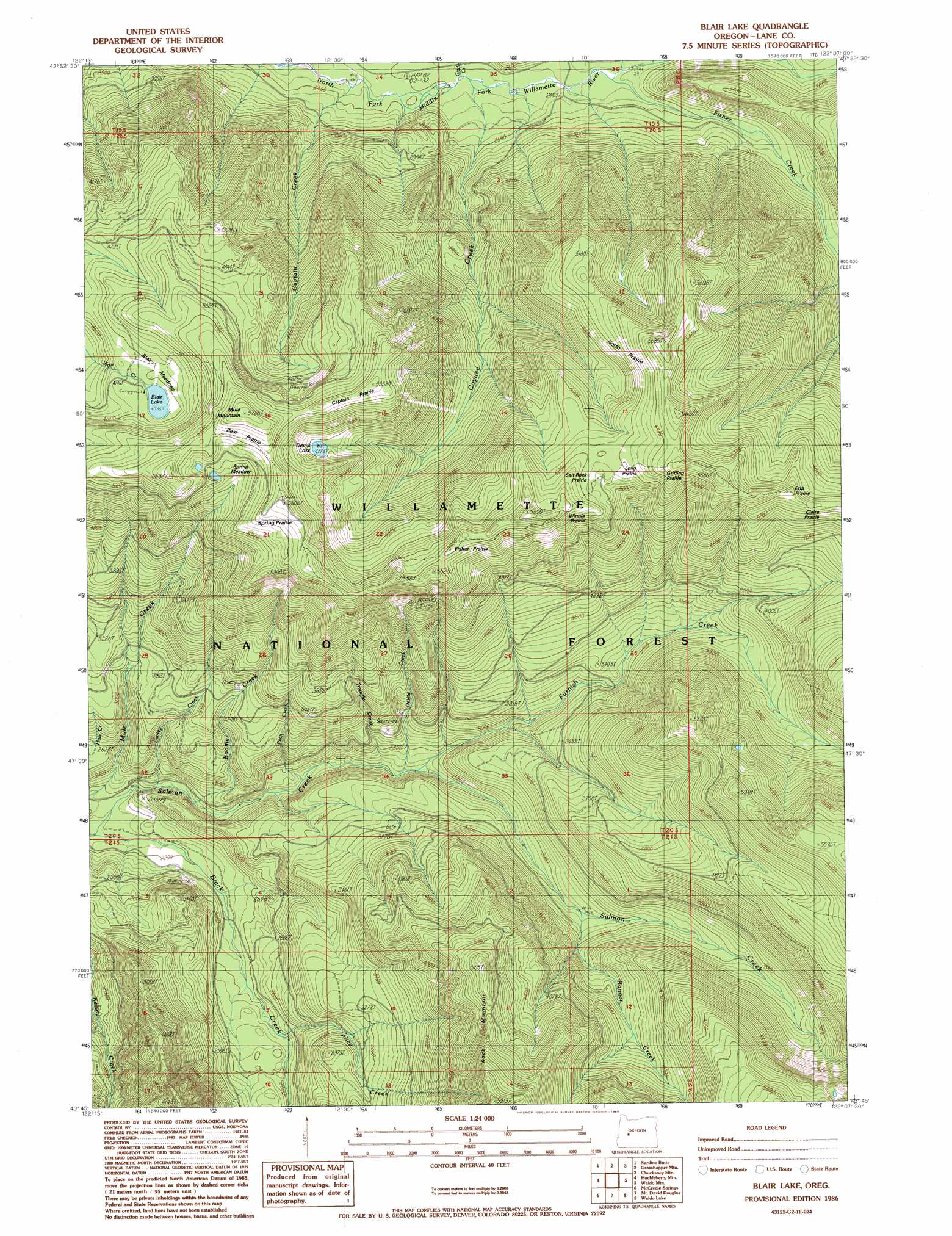
USGS Topo Quad 43122g2 - 1:24,000 scale
| Topo Map Name: | Blair Lake |
| USGS Topo Quad ID: | 43122g2 |
| Print Size: | ca. 21 1/4" wide x 27" high |
| Southeast Coordinates: | 43.75° N latitude / 122.125° W longitude |
| Map Center Coordinates: | 43.8125° N latitude / 122.1875° W longitude |
| U.S. State: | OR |
| Filename: | o43122g2.jpg |
| Download Map JPG Image: | Blair Lake topo map 1:24,000 scale |
| Map Type: | Topographic |
| Topo Series: | 7.5´ |
| Map Scale: | 1:24,000 |
| Source of Map Images: | United States Geological Survey (USGS) |
| Alternate Map Versions: |
Blair Lake OR 1986, updated 1986 Download PDF Buy paper map Blair Lake OR 1997, updated 1998 Download PDF Buy paper map Blair Lake OR 2011 Download PDF Buy paper map Blair Lake OR 2014 Download PDF Buy paper map |
| FStopo: | US Forest Service topo Blair Lake is available: Download FStopo PDF Download FStopo TIF |
1:24,000 Topo Quads surrounding Blair Lake
Nimrod |
Harvey Mountain |
Cougar Reservoir |
French Mountain |
Substitute Point |
Sinker Mountain |
Sardine Butte |
Grasshopper Mountain |
Chucksney Mountain |
Packsaddle Mountain |
Westfir East |
Huckleberry Mountain |
Blair Lake |
Waldo Mountain |
Irish Mountain |
Oakridge |
Mccredie Springs |
Mount David Douglas |
Waldo Lake |
The Twins |
Warner Mountain |
Groundhog Mountain |
Diamond Peak |
Willamette Pass |
Odell Lake |
> Back to 43122e1 at 1:100,000 scale
> Back to 43122a1 at 1:250,000 scale
> Back to U.S. Topo Maps home
Blair Lake topo map: Gazetteer
Blair Lake: Areas
Claire Prairie elevation 1547m 5075′Fisher Prairie elevation 1620m 5314′
Griffing Prairie elevation 1472m 4829′
Winnie Prairie elevation 1608m 5275′
Blair Lake: Flats
Beal Prairie elevation 1597m 5239′Blair Meadows elevation 1480m 4855′
Captain Prairie elevation 1665m 5462′
Etta Prairie elevation 1561m 5121′
Long Prairie elevation 1568m 5144′
North Prairie elevation 1617m 5305′
Salt Rock Prairie elevation 1578m 5177′
Spring Meadow elevation 1535m 5036′
Blair Lake: Lakes
Blair Lake elevation 1451m 4760′Devils Lake elevation 1460m 4790′
Blair Lake: Streams
Alice Creek elevation 756m 2480′Boomer Creek elevation 709m 2326′
Brock Creek elevation 703m 2306′
Captain Creek elevation 721m 2365′
Cayuse Creek elevation 739m 2424′
Curley Creek elevation 681m 2234′
Delate Creek elevation 805m 2641′
Fisher Creek elevation 767m 2516′
Furnish Creek elevation 813m 2667′
Glade Creek elevation 738m 2421′
Koch Creek elevation 740m 2427′
Mule Creek elevation 658m 2158′
Pitch Creek elevation 757m 2483′
Pocher Creek elevation 908m 2979′
Ranger Creek elevation 933m 3061′
Triangle Creek elevation 795m 2608′
Blair Lake: Summits
Mule Mountain elevation 1732m 5682′Mule Mountain Lookout elevation 1664m 5459′
Blair Lake: Trails
Blair Lake Trail elevation 1643m 5390′Salmon Creek Trail elevation 1324m 4343′
Blair Lake digital topo map on disk
Buy this Blair Lake topo map showing relief, roads, GPS coordinates and other geographical features, as a high-resolution digital map file on DVD: