Huckleberry Mountain Topo Map Oregon
To zoom in, hover over the map of Huckleberry Mountain
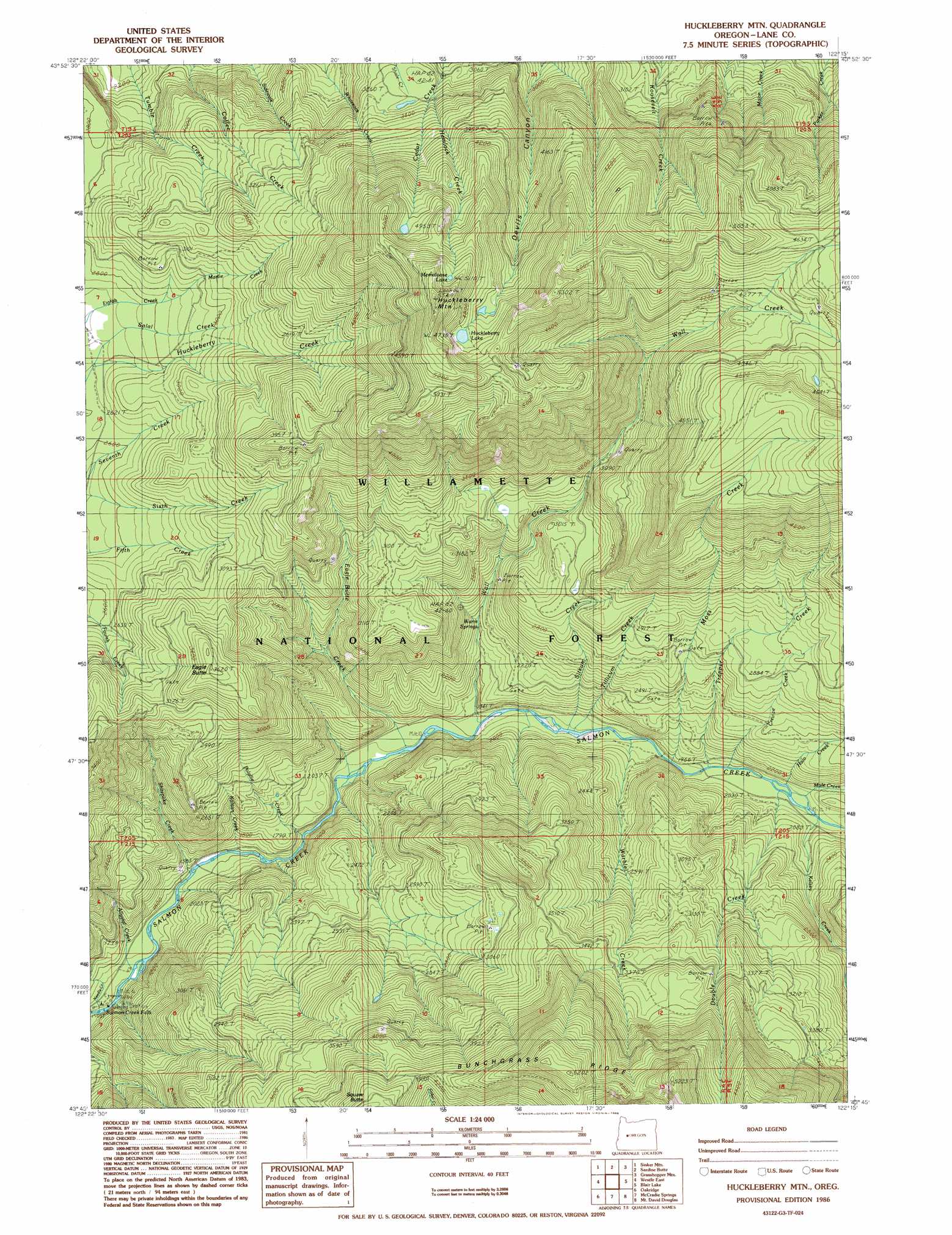
USGS Topo Quad 43122g3 - 1:24,000 scale
| Topo Map Name: | Huckleberry Mountain |
| USGS Topo Quad ID: | 43122g3 |
| Print Size: | ca. 21 1/4" wide x 27" high |
| Southeast Coordinates: | 43.75° N latitude / 122.25° W longitude |
| Map Center Coordinates: | 43.8125° N latitude / 122.3125° W longitude |
| U.S. State: | OR |
| Filename: | o43122g3.jpg |
| Download Map JPG Image: | Huckleberry Mountain topo map 1:24,000 scale |
| Map Type: | Topographic |
| Topo Series: | 7.5´ |
| Map Scale: | 1:24,000 |
| Source of Map Images: | United States Geological Survey (USGS) |
| Alternate Map Versions: |
Huckleberry Mtn OR 1986, updated 1986 Download PDF Buy paper map Huckleberry Mountain OR 1997, updated 1998 Download PDF Buy paper map Huckleberry Mountain OR 2011 Download PDF Buy paper map Huckleberry Mountain OR 2014 Download PDF Buy paper map |
| FStopo: | US Forest Service topo Huckleberry Mountain is available: Download FStopo PDF Download FStopo TIF |
1:24,000 Topo Quads surrounding Huckleberry Mountain
Goat Mountain |
Nimrod |
Harvey Mountain |
Cougar Reservoir |
French Mountain |
Saddleblanket Mountain |
Sinker Mountain |
Sardine Butte |
Grasshopper Mountain |
Chucksney Mountain |
Westfir West |
Westfir East |
Huckleberry Mountain |
Blair Lake |
Waldo Mountain |
Holland Point |
Oakridge |
Mccredie Springs |
Mount David Douglas |
Waldo Lake |
Bearbones Mountain |
Warner Mountain |
Groundhog Mountain |
Diamond Peak |
Willamette Pass |
> Back to 43122e1 at 1:100,000 scale
> Back to 43122a1 at 1:250,000 scale
> Back to U.S. Topo Maps home
Huckleberry Mountain topo map: Gazetteer
Huckleberry Mountain: Falls
Salmon Falls elevation 451m 1479′Huckleberry Mountain: Lakes
Huckleberry Lake elevation 1449m 4753′Memaloose Lake elevation 1560m 5118′
Huckleberry Mountain: Springs
Warm Springs elevation 654m 2145′Huckleberry Mountain: Streams
Alluvial Creek elevation 459m 1505′Black Creek elevation 635m 2083′
Crevice Creek elevation 609m 1998′
Double Creek elevation 617m 2024′
Eagle Butte Creek elevation 537m 1761′
Halo Creek elevation 617m 2024′
Hemlock Creek elevation 1013m 3323′
Horsehead Creek elevation 493m 1617′
Kalitan Creek elevation 472m 1548′
Kelsey Creek elevation 625m 2050′
Martie Creek elevation 856m 2808′
Moss Creek elevation 597m 1958′
Needle Creek elevation 451m 1479′
Polallie Creek elevation 517m 1696′
Shitepoke Creek elevation 491m 1610′
Sitkum Creek elevation 571m 1873′
Tillicum Creek elevation 572m 1876′
Trapper Creek elevation 598m 1961′
Wall Creek elevation 552m 1811′
Warble Creek elevation 586m 1922′
Huckleberry Mountain: Summits
Eagle Butte elevation 1100m 3608′Huckleberry Mountain elevation 1643m 5390′
Huckleberry Mountain: Trails
Dead Mountain Trail elevation 1076m 3530′Roosevelt Way elevation 1500m 4921′
Shitepoke Trail elevation 756m 2480′
Huckleberry Mountain digital topo map on disk
Buy this Huckleberry Mountain topo map showing relief, roads, GPS coordinates and other geographical features, as a high-resolution digital map file on DVD: