Myrtle Creek Topo Map Oregon
To zoom in, hover over the map of Myrtle Creek
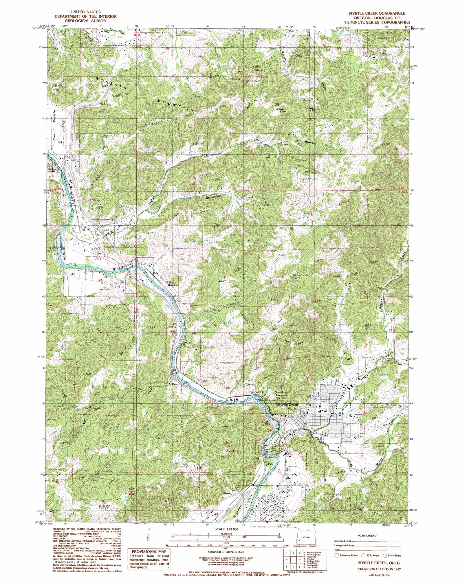
USGS Topo Quad 43123a3 - 1:24,000 scale
| Topo Map Name: | Myrtle Creek |
| USGS Topo Quad ID: | 43123a3 |
| Print Size: | ca. 21 1/4" wide x 27" high |
| Southeast Coordinates: | 43° N latitude / 123.25° W longitude |
| Map Center Coordinates: | 43.0625° N latitude / 123.3125° W longitude |
| U.S. State: | OR |
| Filename: | o43123a3.jpg |
| Download Map JPG Image: | Myrtle Creek topo map 1:24,000 scale |
| Map Type: | Topographic |
| Topo Series: | 7.5´ |
| Map Scale: | 1:24,000 |
| Source of Map Images: | United States Geological Survey (USGS) |
| Alternate Map Versions: |
Myrtle Creek OR 1987, updated 1987 Download PDF Buy paper map Myrtle Creek OR 2011 Download PDF Buy paper map Myrtle Creek OR 2014 Download PDF Buy paper map |
1:24,000 Topo Quads surrounding Myrtle Creek
Callahan |
Garden Valley |
Winchester |
Oak Creek Valley |
Glide |
Reston |
Roseburg West |
Roseburg East |
Dixonville |
Lane Mountain |
Tenmile |
Winston |
Myrtle Creek |
Dodson Butte |
White Rock |
Live Oak Mountain |
Nickel Mountain |
Canyonville |
Days Creek |
Milo |
Rabbit Mountain |
Mccullough Creek |
Quines Creek |
Starvout Creek |
Cedar Springs Mountain |
> Back to 43123a1 at 1:100,000 scale
> Back to 43122a1 at 1:250,000 scale
> Back to U.S. Topo Maps home
Myrtle Creek topo map: Gazetteer
Myrtle Creek: Bridges
Mary Moore Bridge (historical) elevation 167m 547′Myrtle Creek: Flats
Round Prairie elevation 179m 587′Myrtle Creek: Parks
Millsite Park elevation 184m 603′Myrtle Creek: Populated Places
Myrtle Creek elevation 212m 695′Round Prairie elevation 173m 567′
Weaver elevation 207m 679′
Myrtle Creek: Post Offices
Myrtle Creek Post Office elevation 212m 695′Round Prairie Post Office (historical) elevation 173m 567′
Ruckles Post Office (historical) elevation 174m 570′
Myrtle Creek: Reservoirs
Engles and Worth Log Pond elevation 197m 646′Myrtle Creek: Streams
Bilger Creek elevation 203m 666′Clark Branch elevation 164m 538′
Harrison Young Brook elevation 197m 646′
Myrtle Creek elevation 182m 597′
North Myrtle Creek elevation 184m 603′
Richardson Creek elevation 206m 675′
Rock Creek elevation 243m 797′
South Myrtle Creek elevation 184m 603′
Van Dine Creek elevation 171m 561′
Myrtle Creek: Summits
Gobblers Knob elevation 318m 1043′Roberts Mountain elevation 380m 1246′
Sheep Hill elevation 784m 2572′
Myrtle Creek: Valleys
Cedar Hollow elevation 228m 748′Myrtle Creek digital topo map on disk
Buy this Myrtle Creek topo map showing relief, roads, GPS coordinates and other geographical features, as a high-resolution digital map file on DVD: