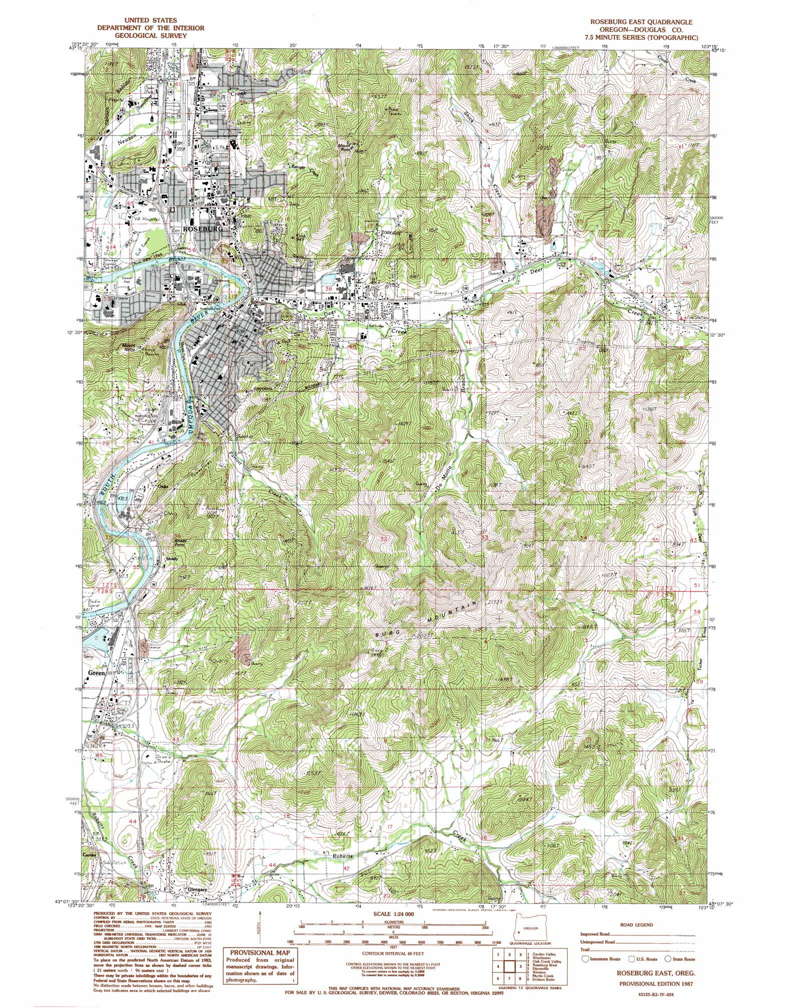
Roseburg East Topo Map Oregon
To zoom in, hover over the map of Roseburg East
USGS Topo Quad 43123b3 - 1:24,000 scale
| Topo Map Name: | Roseburg East |
| USGS Topo Quad ID: | 43123b3 |
| Print Size: | ca. 21 1/4" wide x 27" high |
| Southeast Coordinates: | 43.125° N latitude / 123.25° W longitude |
| Map Center Coordinates: | 43.1875° N latitude / 123.3125° W longitude |
| U.S. State: | OR |
| Filename: | o43123b3.jpg |
| Download Map JPG Image: | Roseburg East topo map 1:24,000 scale |
| Map Type: | Topographic |
| Topo Series: | 7.5´ |
| Map Scale: | 1:24,000 |
| Source of Map Images: | United States Geological Survey (USGS) |
| Alternate Map Versions: |
Roseburg East OR 1987, updated 1987 Download PDF Buy paper map Roseburg East OR 1987, updated 1987 Download PDF Buy paper map Roseburg East OR 2011 Download PDF Buy paper map Roseburg East OR 2014 Download PDF Buy paper map |
1:24,000 Topo Quads surrounding Roseburg East
Tyee |
Tyee Mountain |
Sutherlin |
Nonpareil |
Hinkle Creek |
Callahan |
Garden Valley |
Winchester |
Oak Creek Valley |
Glide |
Reston |
Roseburg West |
Roseburg East |
Dixonville |
Lane Mountain |
Tenmile |
Winston |
Myrtle Creek |
Dodson Butte |
White Rock |
Live Oak Mountain |
Nickel Mountain |
Canyonville |
Days Creek |
Milo |
> Back to 43123a1 at 1:100,000 scale
> Back to 43122a1 at 1:250,000 scale
> Back to U.S. Topo Maps home
Roseburg East topo map: Gazetteer
Roseburg East: Airports
Roseburg Municipal Airport elevation 157m 515′Roseburg East: Cliffs
Shady Point elevation 250m 820′Roseburg East: Dams
Ornoname 12 Dam elevation 152m 498′Ornoname 8 Dam elevation 148m 485′
Perkins Log Pond Dam elevation 158m 518′
Youngs Bay Lumber Company Dam elevation 149m 488′
Roseburg East: Islands
Elk Island (historical) elevation 135m 442′Roseburg East: Parks
Beulah Park elevation 207m 679′Charles S Gardiner Park elevation 140m 459′
Commercial Street Park elevation 144m 472′
Deer Creek Park elevation 136m 446′
Eagles Park elevation 153m 501′
Eastwood Park elevation 141m 462′
Fir Grove Section of Stewart Park elevation 126m 413′
Gaddis Park elevation 130m 426′
Laurelwood Park elevation 137m 449′
Micelli Park elevation 135m 442′
Parrott Creek Park elevation 155m 508′
River Front Park elevation 136m 446′
Riverside Park elevation 134m 439′
Roseburg Skate Park elevation 134m 439′
South Knoll Park (historical) elevation 196m 643′
Stewart Park elevation 130m 426′
Stewart Park Wildlife Pond elevation 134m 439′
Sunshine Park elevation 165m 541′
Templin Beach Park elevation 134m 439′
Thompson Park elevation 164m 538′
Umpqua Park elevation 137m 449′
Willis Park elevation 148m 485′
Roseburg East: Populated Places
Green elevation 157m 515′Oaks elevation 157m 515′
Roseburg elevation 147m 482′
Roseburg East: Post Offices
Alderbrook Post Office (historical) elevation 171m 561′Roseburg Post Office elevation 157m 515′
Roseburg East: Reservoirs
Iverson Log Ponds elevation 144m 472′Melton Reservoir elevation 196m 643′
Nordic Log Pond elevation 163m 534′
Park Lake elevation 134m 439′
Perkins Log Pond elevation 158m 518′
Sun Studs Log Pond elevation 148m 485′
Umpqua Log Pond elevation 154m 505′
Youngs Bay Lumber Company Pond elevation 149m 488′
Roseburg East: Streams
Barager Creek elevation 358m 1174′DaMotta Branch elevation 148m 485′
Deer Creek elevation 134m 439′
Parrott Creek elevation 146m 479′
Roberts Creek elevation 135m 442′
Shady Point Creek elevation 135m 442′
Shick Creek elevation 152m 498′
Sleepy Hollow Creek elevation 198m 649′
Roseburg East: Summits
Burg Mountain elevation 600m 1968′Mount Nebo elevation 341m 1118′
Mount Rose elevation 430m 1410′
Roseburg East digital topo map on disk
Buy this Roseburg East topo map showing relief, roads, GPS coordinates and other geographical features, as a high-resolution digital map file on DVD: