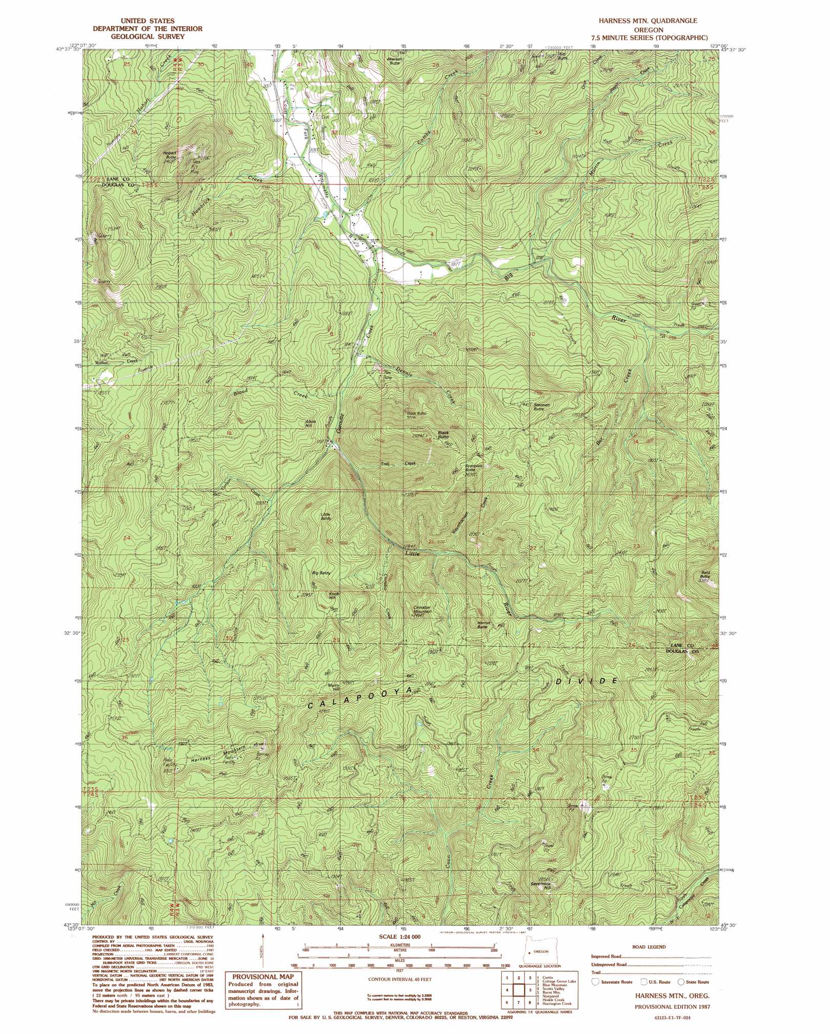
Harness Mountain Topo Map Oregon
To zoom in, hover over the map of Harness Mountain
USGS Topo Quad 43123e1 - 1:24,000 scale
| Topo Map Name: | Harness Mountain |
| USGS Topo Quad ID: | 43123e1 |
| Print Size: | ca. 21 1/4" wide x 27" high |
| Southeast Coordinates: | 43.5° N latitude / 123° W longitude |
| Map Center Coordinates: | 43.5625° N latitude / 123.0625° W longitude |
| U.S. State: | OR |
| Filename: | o43123e1.jpg |
| Download Map JPG Image: | Harness Mountain topo map 1:24,000 scale |
| Map Type: | Topographic |
| Topo Series: | 7.5´ |
| Map Scale: | 1:24,000 |
| Source of Map Images: | United States Geological Survey (USGS) |
| Alternate Map Versions: |
Harness Mtn OR 1987, updated 1987 Download PDF Buy paper map Harness Mountain OR 2011 Download PDF Buy paper map Harness Mountain OR 2014 Download PDF Buy paper map |
1:24,000 Topo Quads surrounding Harness Mountain
Letz Creek |
Lorane |
Cottage Grove |
Dorena Lake |
Kloster Mountain |
Drain |
Curtin |
Cottage Grove Lake |
Blue Mountain |
Culp Creek |
Yoncalla |
Scotts Valley |
Harness Mountain |
Burnt Mountain |
Silica Mountain |
Sutherlin |
Nonpareil |
Hinkle Creek |
Harrington Creek |
Scaredman Creek |
Winchester |
Oak Creek Valley |
Glide |
Old Fairview |
Mace Mountain |
> Back to 43123e1 at 1:100,000 scale
> Back to 43122a1 at 1:250,000 scale
> Back to U.S. Topo Maps home
Harness Mountain topo map: Gazetteer
Harness Mountain: Bridges
Rouse Bridge elevation 280m 918′Harness Mountain: Mines
Black Butte Mine elevation 540m 1771′Harness Mountain: Populated Places
Amos (historical) elevation 299m 980′Black Butte elevation 347m 1138′
Harness Mountain: Post Offices
Amos Post Office (historical) elevation 299m 980′Blackbutte Post Office (historical) elevation 346m 1135′
Louis Post Office (historical) elevation 616m 2020′
Harness Mountain: Streams
Bar Creek elevation 344m 1128′Big River elevation 306m 1003′
Blood Creek elevation 338m 1108′
Brauti Creek elevation 396m 1299′
Carlson Creek elevation 396m 1299′
Cinnabar Creek elevation 393m 1289′
Combs Creek elevation 297m 974′
Deer Creek elevation 285m 935′
Dennis Creek elevation 321m 1053′
Drue Creek elevation 493m 1617′
East Cinnabar Creek elevation 407m 1335′
Garoutte Creek elevation 347m 1138′
Hambrick Creek elevation 288m 944′
Jasper Creek elevation 343m 1125′
Little River elevation 300m 984′
Martin Creek elevation 344m 1128′
Norman Creek elevation 404m 1325′
Rouse Creek elevation 283m 928′
Trail Creek elevation 386m 1266′
Weyerhaeuser Creek elevation 440m 1443′
Harness Mountain: Summits
Akerson Butte elevation 649m 2129′Alton Hill elevation 503m 1650′
Bald Butte elevation 1129m 3704′
Big Baldy elevation 475m 1558′
Black Butte elevation 820m 2690′
Cinnabar Mountain elevation 752m 2467′
Harness Mountain elevation 1006m 3300′
Hobart Butte elevation 755m 2477′
Hornet Butte elevation 692m 2270′
Knob Hill elevation 745m 2444′
Little Baldy elevation 618m 2027′
Murry Hill elevation 881m 2890′
Scorpion Butte elevation 791m 2595′
Sevenmile Hill elevation 827m 2713′
Stennett Butte elevation 762m 2500′
Witt Butte elevation 804m 2637′
Harness Mountain digital topo map on disk
Buy this Harness Mountain topo map showing relief, roads, GPS coordinates and other geographical features, as a high-resolution digital map file on DVD: