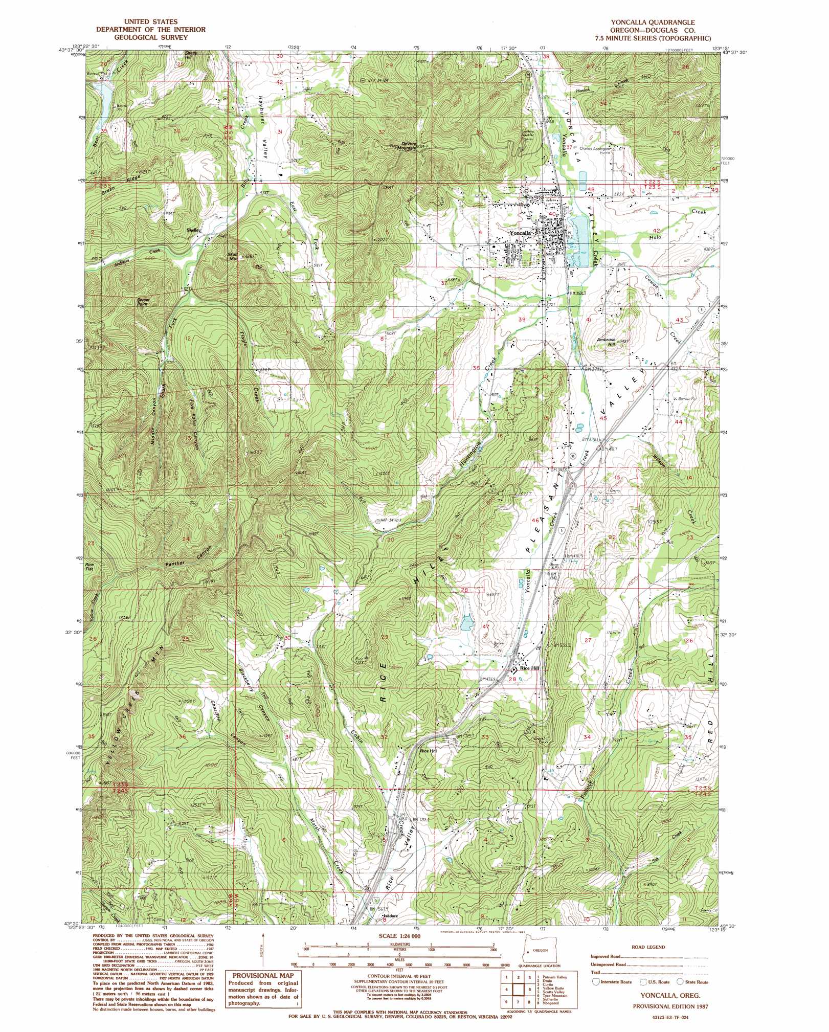
Yoncalla Topo Map Oregon
To zoom in, hover over the map of Yoncalla
USGS Topo Quad 43123e3 - 1:24,000 scale
| Topo Map Name: | Yoncalla |
| USGS Topo Quad ID: | 43123e3 |
| Print Size: | ca. 21 1/4" wide x 27" high |
| Southeast Coordinates: | 43.5° N latitude / 123.25° W longitude |
| Map Center Coordinates: | 43.5625° N latitude / 123.3125° W longitude |
| U.S. State: | OR |
| Filename: | o43123e3.jpg |
| Download Map JPG Image: | Yoncalla topo map 1:24,000 scale |
| Map Type: | Topographic |
| Topo Series: | 7.5´ |
| Map Scale: | 1:24,000 |
| Source of Map Images: | United States Geological Survey (USGS) |
| Alternate Map Versions: |
Yoncalla OR 1987, updated 1987 Download PDF Buy paper map Yoncalla OR 2011 Download PDF Buy paper map Yoncalla OR 2014 Download PDF Buy paper map |
1:24,000 Topo Quads surrounding Yoncalla
Gunter |
Beaver Creek |
Letz Creek |
Lorane |
Cottage Grove |
Elkton |
Putnam Valley |
Drain |
Curtin |
Cottage Grove Lake |
Kellogg |
Yellow Butte |
Yoncalla |
Scotts Valley |
Harness Mountain |
Tyee |
Tyee Mountain |
Sutherlin |
Nonpareil |
Hinkle Creek |
Callahan |
Garden Valley |
Winchester |
Oak Creek Valley |
Glide |
> Back to 43123e1 at 1:100,000 scale
> Back to 43122a1 at 1:250,000 scale
> Back to U.S. Topo Maps home
Yoncalla topo map: Gazetteer
Yoncalla: Basins
Yoncalla Valley elevation 110m 360′Yoncalla: Dams
Bear Creek Dam elevation 219m 718′Weaver Dam elevation 177m 580′
Yoncalla Lumber Company Log Pond Dam elevation 107m 351′
Yoncalla: Gaps
Cougar Pass elevation 222m 728′Yoncalla: Populated Places
Rice Hill elevation 139m 456′Yoncalla elevation 112m 367′
Yoncalla: Post Offices
Locust Grove Post Office (historical) elevation 194m 636′Rice Hill Post Office (historical) elevation 229m 751′
Skelley Post Office (historical) elevation 211m 692′
Yoncalla Post Office elevation 112m 367′
Yoncalla: Reservoirs
Bear Creek Reservoir elevation 219m 718′Thurman Weaver Reservoir elevation 156m 511′
Weaver Reservoir elevation 177m 580′
Yoncalla Log Pond elevation 108m 354′
Yoncalla Lumber Company Log Pond elevation 107m 351′
Yoncalla: Streams
Andrews Creek elevation 149m 488′Cold Creek elevation 138m 452′
Cowan Creek elevation 108m 354′
East Fork Billy Creek elevation 146m 479′
Flagler Creek elevation 149m 488′
Halo Creek elevation 108m 354′
Hanlon Creek elevation 101m 331′
Huntington Creek elevation 110m 360′
Kopp Creek elevation 183m 600′
Lost Cabin Creek elevation 228m 748′
Marsh Creek elevation 175m 574′
McDaniel Creek elevation 110m 360′
North Fork Wilson Creek elevation 197m 646′
Poodle Creek elevation 117m 383′
Salt Creek elevation 204m 669′
South Fork Billy Creek elevation 148m 485′
South Fork Flagler Creek elevation 205m 672′
Wilson Creek elevation 122m 400′
Yoncalla: Summits
Ambrose Hill elevation 216m 708′DeVore Mountain elevation 399m 1309′
Rice Hill elevation 359m 1177′
Skull Mountain elevation 345m 1131′
Sweet Point elevation 389m 1276′
Yoncalla: Valleys
Blackberry Canyon elevation 207m 679′Churchill Canyon elevation 207m 679′
Five Point Canyon elevation 168m 551′
Halo Valley elevation 132m 433′
Hayhurst Valley elevation 142m 465′
Middle Canyon elevation 197m 646′
Panther Canyon elevation 290m 951′
Yoncalla digital topo map on disk
Buy this Yoncalla topo map showing relief, roads, GPS coordinates and other geographical features, as a high-resolution digital map file on DVD: