Cottage Grove Lake Topo Map Oregon
To zoom in, hover over the map of Cottage Grove Lake
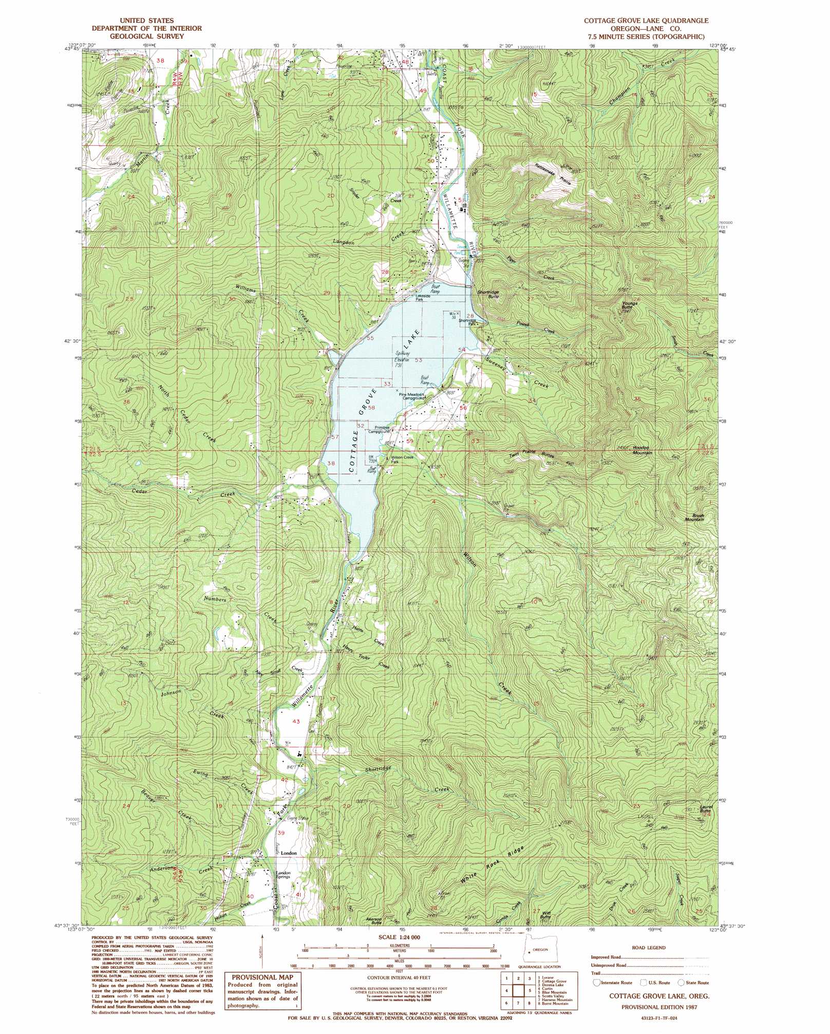
USGS Topo Quad 43123f1 - 1:24,000 scale
| Topo Map Name: | Cottage Grove Lake |
| USGS Topo Quad ID: | 43123f1 |
| Print Size: | ca. 21 1/4" wide x 27" high |
| Southeast Coordinates: | 43.625° N latitude / 123° W longitude |
| Map Center Coordinates: | 43.6875° N latitude / 123.0625° W longitude |
| U.S. State: | OR |
| Filename: | o43123f1.jpg |
| Download Map JPG Image: | Cottage Grove Lake topo map 1:24,000 scale |
| Map Type: | Topographic |
| Topo Series: | 7.5´ |
| Map Scale: | 1:24,000 |
| Source of Map Images: | United States Geological Survey (USGS) |
| Alternate Map Versions: |
Cottage Grove Lake OR 1987, updated 1987 Download PDF Buy paper map Cottage Grove Lake OR 2011 Download PDF Buy paper map Cottage Grove Lake OR 2014 Download PDF Buy paper map |
1:24,000 Topo Quads surrounding Cottage Grove Lake
Crow |
Fox Hollow |
Creswell |
Jasper |
Lowell |
Letz Creek |
Lorane |
Cottage Grove |
Dorena Lake |
Kloster Mountain |
Drain |
Curtin |
Cottage Grove Lake |
Blue Mountain |
Culp Creek |
Yoncalla |
Scotts Valley |
Harness Mountain |
Burnt Mountain |
Silica Mountain |
Sutherlin |
Nonpareil |
Hinkle Creek |
Harrington Creek |
Scaredman Creek |
> Back to 43123e1 at 1:100,000 scale
> Back to 43122a1 at 1:250,000 scale
> Back to U.S. Topo Maps home
Cottage Grove Lake topo map: Gazetteer
Cottage Grove Lake: Bridges
Army Bridge elevation 244m 800′Thorne Bridge elevation 257m 843′
Cottage Grove Lake: Dams
Cottage Grove Dam elevation 242m 793′Cottage Grove Lake: Flats
Rattlesnake Prairie elevation 442m 1450′Cottage Grove Lake: Parks
Lakeside Park elevation 243m 797′Shortridge Park elevation 244m 800′
Wilson Creek Park elevation 245m 803′
Cottage Grove Lake: Populated Places
Gap elevation 214m 702′London elevation 274m 898′
London Springs elevation 273m 895′
Wallace (historical) elevation 257m 843′
Cottage Grove Lake: Post Offices
London Post Office (historical) elevation 272m 892′Wallace Post Office (historical) elevation 257m 843′
Cottage Grove Lake: Reservoirs
Cottage Grove Lake elevation 242m 793′Williams Lake elevation 317m 1040′
Cottage Grove Lake: Ridges
White Rock Ridge elevation 808m 2650′Cottage Grove Lake: Streams
Alex Small Creek elevation 256m 839′Anderson Creek elevation 270m 885′
Beaver Creek elevation 292m 958′
Beck Creek elevation 307m 1007′
Cedar Creek elevation 243m 797′
Champion Creek elevation 258m 846′
Elkhorn Creek elevation 216m 708′
Ewing Creek elevation 263m 862′
H Taylor Creek elevation 273m 895′
Harris Creek elevation 250m 820′
Harvey Creek elevation 245m 803′
Hobart Creek elevation 271m 889′
Johnson Creek elevation 253m 830′
Langdon Creek elevation 216m 708′
Massey Creek elevation 285m 935′
McWilliams Creek elevation 428m 1404′
Murray Creek elevation 242m 793′
North Cedar Creek elevation 243m 797′
Numbers Creek elevation 245m 803′
Piper Creek elevation 221m 725′
Powell Creek elevation 243m 797′
Rodgers Creek elevation 242m 793′
Sheldon Creek elevation 211m 692′
Shortridge Creek elevation 275m 902′
Snyder Creek elevation 221m 725′
Sweeney Creek elevation 244m 800′
Wallace Creek elevation 209m 685′
Whites Creek elevation 212m 695′
Whitney Creek elevation 220m 721′
Williams Creek elevation 246m 807′
Wilson Creek elevation 243m 797′
Youngs Creek elevation 247m 810′
Cottage Grove Lake: Summits
Brush Mountain elevation 704m 2309′Chapman Butte elevation 525m 1722′
Hoodoo Mountain elevation 745m 2444′
Indian Butte elevation 510m 1673′
Kellys Butte elevation 572m 1876′
Laurel Butte elevation 1009m 3310′
Shortridge Butte elevation 447m 1466′
Twin Prairie Buttes elevation 503m 1650′
Youngs Butte elevation 608m 1994′
Cottage Grove Lake digital topo map on disk
Buy this Cottage Grove Lake topo map showing relief, roads, GPS coordinates and other geographical features, as a high-resolution digital map file on DVD: