Clay Creek Topo Map Oregon
To zoom in, hover over the map of Clay Creek
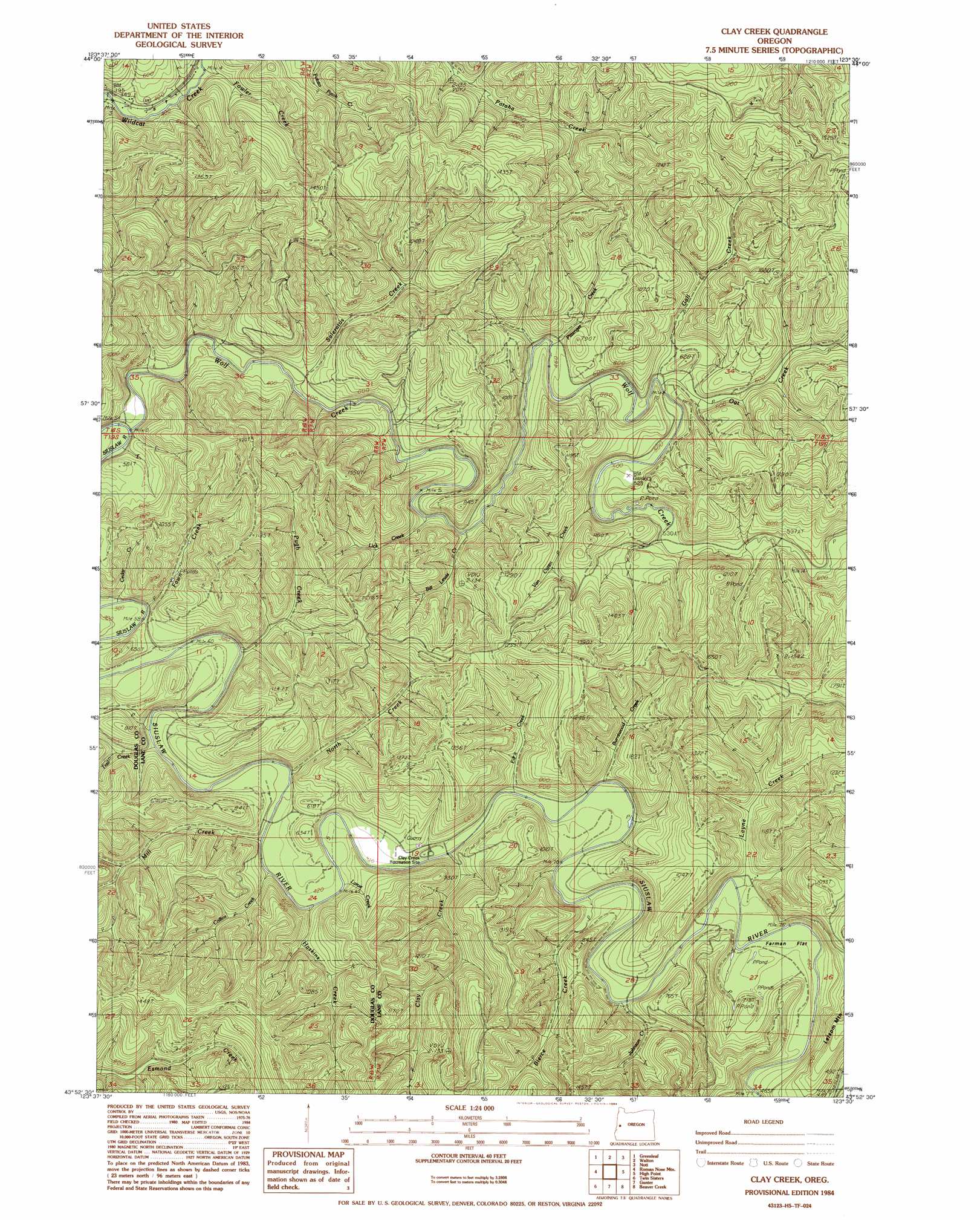
USGS Topo Quad 43123h5 - 1:24,000 scale
| Topo Map Name: | Clay Creek |
| USGS Topo Quad ID: | 43123h5 |
| Print Size: | ca. 21 1/4" wide x 27" high |
| Southeast Coordinates: | 43.875° N latitude / 123.5° W longitude |
| Map Center Coordinates: | 43.9375° N latitude / 123.5625° W longitude |
| U.S. State: | OR |
| Filename: | o43123h5.jpg |
| Download Map JPG Image: | Clay Creek topo map 1:24,000 scale |
| Map Type: | Topographic |
| Topo Series: | 7.5´ |
| Map Scale: | 1:24,000 |
| Source of Map Images: | United States Geological Survey (USGS) |
| Alternate Map Versions: |
Clay Creek OR 1984, updated 1984 Download PDF Buy paper map Clay Creek OR 2011 Download PDF Buy paper map Clay Creek OR 2014 Download PDF Buy paper map |
1:24,000 Topo Quads surrounding Clay Creek
Herman Creek |
Windy Peak |
Triangle Lake |
Horton |
Cheshire |
Mapleton |
Greenleaf |
Walton |
Noti |
Veneta |
Baldy Mountain |
Roman Nose Mountain |
Clay Creek |
High Point |
Crow |
Smith River Falls |
Twin Sisters |
Gunter |
Beaver Creek |
Letz Creek |
Scottsburg |
Devils Graveyard |
Elkton |
Putnam Valley |
Drain |
> Back to 43123e1 at 1:100,000 scale
> Back to 43122a1 at 1:250,000 scale
> Back to U.S. Topo Maps home
Clay Creek topo map: Gazetteer
Clay Creek: Flats
Farman Flat elevation 145m 475′Clay Creek: Parks
Clay Creek Recreation Site elevation 133m 436′Clay Creek: Reservoirs
Clay Creek Recreational Reservoir elevation 129m 423′Clay Creek: Streams
Bierce Creek elevation 133m 436′Bill Lewis Creek elevation 146m 479′
Burntwood Creek elevation 188m 616′
Clay Creek elevation 129m 423′
Collins Creek elevation 163m 534′
Edris Creek elevation 135m 442′
Fawn Creek elevation 117m 383′
Fowler Creek elevation 140m 459′
Gall Creek elevation 170m 557′
Haskins Creek elevation 192m 629′
Johnson Creek elevation 135m 442′
Larue Creek elevation 125m 410′
Layne Creek elevation 139m 456′
Lick Creek elevation 136m 446′
Mill Creek elevation 203m 666′
North Creek elevation 122m 400′
Oat Creek elevation 149m 488′
Pittenger Creek elevation 140m 459′
Pugh Creek elevation 123m 403′
Saleratus Creek elevation 141m 462′
Trail Creek elevation 230m 754′
Trail Creek elevation 115m 377′
Van Curen Creek elevation 177m 580′
Wolf Creek elevation 105m 344′
Clay Creek: Summits
Letsom Mountain elevation 304m 997′Clay Creek: Valleys
Cougar Gulch elevation 170m 557′Clay Creek digital topo map on disk
Buy this Clay Creek topo map showing relief, roads, GPS coordinates and other geographical features, as a high-resolution digital map file on DVD: