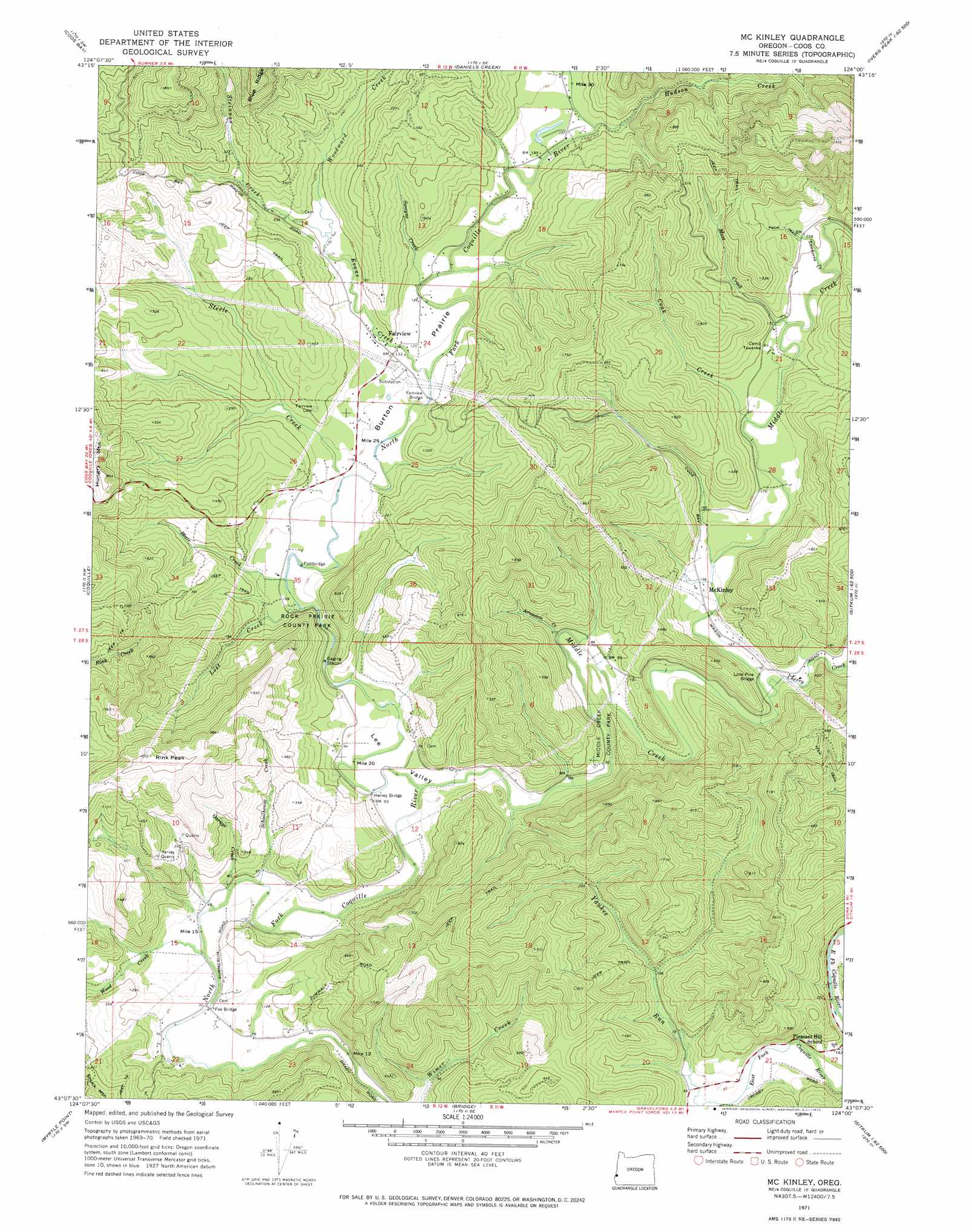
Mckinley Topo Map Oregon
To zoom in, hover over the map of Mckinley
USGS Topo Quad 43124b1 - 1:24,000 scale
| Topo Map Name: | Mckinley |
| USGS Topo Quad ID: | 43124b1 |
| Print Size: | ca. 21 1/4" wide x 27" high |
| Southeast Coordinates: | 43.125° N latitude / 124° W longitude |
| Map Center Coordinates: | 43.1875° N latitude / 124.0625° W longitude |
| U.S. State: | OR |
| Filename: | o43124b1.jpg |
| Download Map JPG Image: | Mckinley topo map 1:24,000 scale |
| Map Type: | Topographic |
| Topo Series: | 7.5´ |
| Map Scale: | 1:24,000 |
| Source of Map Images: | United States Geological Survey (USGS) |
| Alternate Map Versions: |
Mc Kinley OR 1971, updated 1973 Download PDF Buy paper map McKinley OR 2011 Download PDF Buy paper map McKinley OR 2014 Download PDF Buy paper map |
1:24,000 Topo Quads surrounding Mckinley
Empire |
North Bend |
Allegany |
Golden Falls |
Ivers Peak |
Charleston |
Coos Bay |
Daniels Creek |
Coos Mountain |
Tioga |
Riverton |
Coquille |
Mckinley |
Dora |
Sitkum |
Bill Peak |
Myrtle Point |
Bridge |
Remote |
Kenyon Mountain |
Calf Ranch Mountain |
Dement Creek |
Powers |
Rasler Creek |
Bone Mountain |
> Back to 43124a1 at 1:100,000 scale
> Back to 43124a1 at 1:250,000 scale
> Back to U.S. Topo Maps home
Mckinley topo map: Gazetteer
Mckinley: Bridges
Fairview Bridge elevation 38m 124′Fox Bridge elevation 16m 52′
Hervey Bridge elevation 20m 65′
Lone Pine Bridge elevation 35m 114′
Mckinley: Falls
Middle Creek Falls elevation 50m 164′Mckinley: Flats
Burton Prairie elevation 40m 131′Mckinley: Mines
Hervey Quarry elevation 182m 597′Mckinley: Parks
Middle Creek County Park elevation 35m 114′Rock Prairie County Park elevation 74m 242′
Mckinley: Populated Places
Fairview elevation 40m 131′Lee (historical) elevation 25m 82′
McKinley elevation 42m 137′
Mckinley: Post Offices
Fairview Post Office (historical) elevation 40m 131′Lee Post Office (historical) elevation 27m 88′
Luda Post Office (historical) elevation 45m 147′
McKinley Post Office (historical) elevation 42m 137′
Sidney Post Office (historical) elevation 22m 72′
Mckinley: Streams
Blair Creek elevation 32m 104′Cherry Creek elevation 35m 114′
Coak Creek elevation 45m 147′
Evans Creek elevation 38m 124′
Fall Creek elevation 19m 62′
Garage Creek elevation 18m 59′
Hatcher Creek elevation 39m 127′
Hudson Creek elevation 44m 144′
Jerusalem Creek elevation 32m 104′
Lawhorne Creek elevation 49m 160′
Lost Creek elevation 28m 91′
Mast Creek elevation 49m 160′
Middle Creek elevation 19m 62′
North Fork Wood Creek elevation 43m 141′
Schoolhouse Creek elevation 17m 55′
Steele Creek elevation 38m 124′
Steinnon Creek elevation 53m 173′
Swayne Creek elevation 40m 131′
Wood Creek elevation 18m 59′
Woodward Creek elevation 53m 173′
Mckinley: Summits
Hungry Mountain elevation 256m 839′Rink Peak elevation 320m 1049′
Mckinley: Valleys
Lee Valley elevation 23m 75′Mckinley digital topo map on disk
Buy this Mckinley topo map showing relief, roads, GPS coordinates and other geographical features, as a high-resolution digital map file on DVD: