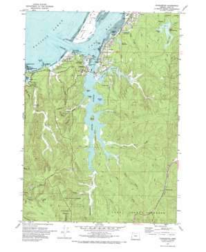
Charleston Topo Map Oregon
To zoom in, hover over the map of Charleston
USGS Topo Quad 43124c3 - 1:24,000 scale
| Topo Map Name: | Charleston |
| USGS Topo Quad ID: | 43124c3 |
| Print Size: | ca. 21 1/4" wide x 27" high |
| Southeast Coordinates: | 43.25° N latitude / 124.25° W longitude |
| Map Center Coordinates: | 43.3125° N latitude / 124.3125° W longitude |
| U.S. State: | OR |
| Filename: | o43124c3.jpg |
| Download Map JPG Image: | Charleston topo map 1:24,000 scale |
| Map Type: | Topographic |
| Topo Series: | 7.5´ |
| Map Scale: | 1:24,000 |
| Source of Map Images: | United States Geological Survey (USGS) |
| Alternate Map Versions: |
Charleston OR 1970, updated 1974 Download PDF Buy paper map Charleston OR 2011 Download PDF Buy paper map Charleston OR 2014 Download PDF Buy paper map |
1:24,000 Topo Quads surrounding Charleston
Lakeside |
Trail Butte |
|||
Empire |
North Bend |
Allegany |
||
Cape Arago |
Charleston |
Coos Bay |
Daniels Creek |
|
Bullards |
Riverton |
Coquille |
Mckinley |
|
Bandon |
Bill Peak |
Myrtle Point |
Bridge |
> Back to 43124a1 at 1:100,000 scale
> Back to 43124a1 at 1:250,000 scale
> Back to U.S. Topo Maps home
Charleston topo map: Gazetteer
Charleston: Bars
Mussel Reef elevation 0m 0′Charleston: Bays
Browns Cove elevation 0m 0′Day Inlet elevation 7m 22′
Haywood Inlet elevation 16m 52′
Libby Arm elevation 27m 88′
Tarheel Arm elevation 26m 85′
Charleston: Beaches
Bastendorff Beach elevation 0m 0′Lighthouse Beach elevation 13m 42′
Charleston: Capes
Collver Point elevation 5m 16′Coos Head elevation 0m 0′
Fossil Point elevation 15m 49′
Long Island Point elevation 0m 0′
Pigeon Point elevation 0m 0′
Yoakam Point elevation 11m 36′
Younker Point elevation 14m 45′
Charleston: Channels
Entrance Range elevation 0m 0′Inside Range elevation 0m 0′
Charleston: Cliffs
Tunnel Point elevation 7m 22′Charleston: Dams
North Jetty elevation 0m 0′South Jetty elevation 0m 0′
Tarheel Creek Dam elevation 12m 39′
Upper Pony Creek Dam elevation 26m 85′
Charleston: Guts
Joe Ney Slough elevation 0m 0′South Slough elevation 0m 0′
Charleston: Islands
Guano Rock elevation 0m 0′Valino Island elevation 24m 78′
Charleston: Mines
Chickamin Mine elevation 23m 75′Charleston: Parks
Barview State Wayside (historical) elevation 4m 13′Bastendorff Beach County Park elevation 4m 13′
Charleston Fishing Pier elevation 1m 3′
Sunset Bay State Park elevation 6m 19′
Yoakam Point State Park elevation 19m 62′
Charleston: Populated Places
Barview elevation 7m 22′Charleston elevation 31m 101′
Crown Point elevation 45m 147′
Charleston: Post Offices
Charleston Post Office elevation 31m 101′South Inlet Post Office (historical) elevation 41m 134′
Charleston: Reservoirs
Fourth Creek Reservoir elevation 6m 19′Tarheel Reservoir elevation 12m 39′
Third Creek Reservoir elevation 9m 29′
Upper Pony Creek Reservoir elevation 26m 85′
Charleston: Streams
Chard Creek elevation 70m 229′Day Creek elevation 0m 0′
Elliott Creek elevation 0m 0′
Farley Creek elevation 7m 22′
Fourth Creek elevation 7m 22′
Fox Creek elevation 8m 26′
Hayward Creek elevation 5m 16′
John B Creek elevation 14m 45′
Miner Creek elevation 1m 3′
North Fork Joe Ney Slough elevation 2m 6′
South Fork Joe Ney Slough elevation 3m 9′
Storey Creek elevation 6m 19′
Talbot Creek elevation 0m 0′
Talbott Slough elevation 7m 22′
Tarheel Creek elevation 1m 3′
Theodore Johnston Creek elevation 4m 13′
Wasson Creek elevation 6m 19′
Winchester Creek elevation 0m 0′
Charleston: Summits
Yoakam Hill elevation 115m 377′Charleston: Valleys
Cox Canyon elevation 5m 16′Charleston digital topo map on disk
Buy this Charleston topo map showing relief, roads, GPS coordinates and other geographical features, as a high-resolution digital map file on DVD:


