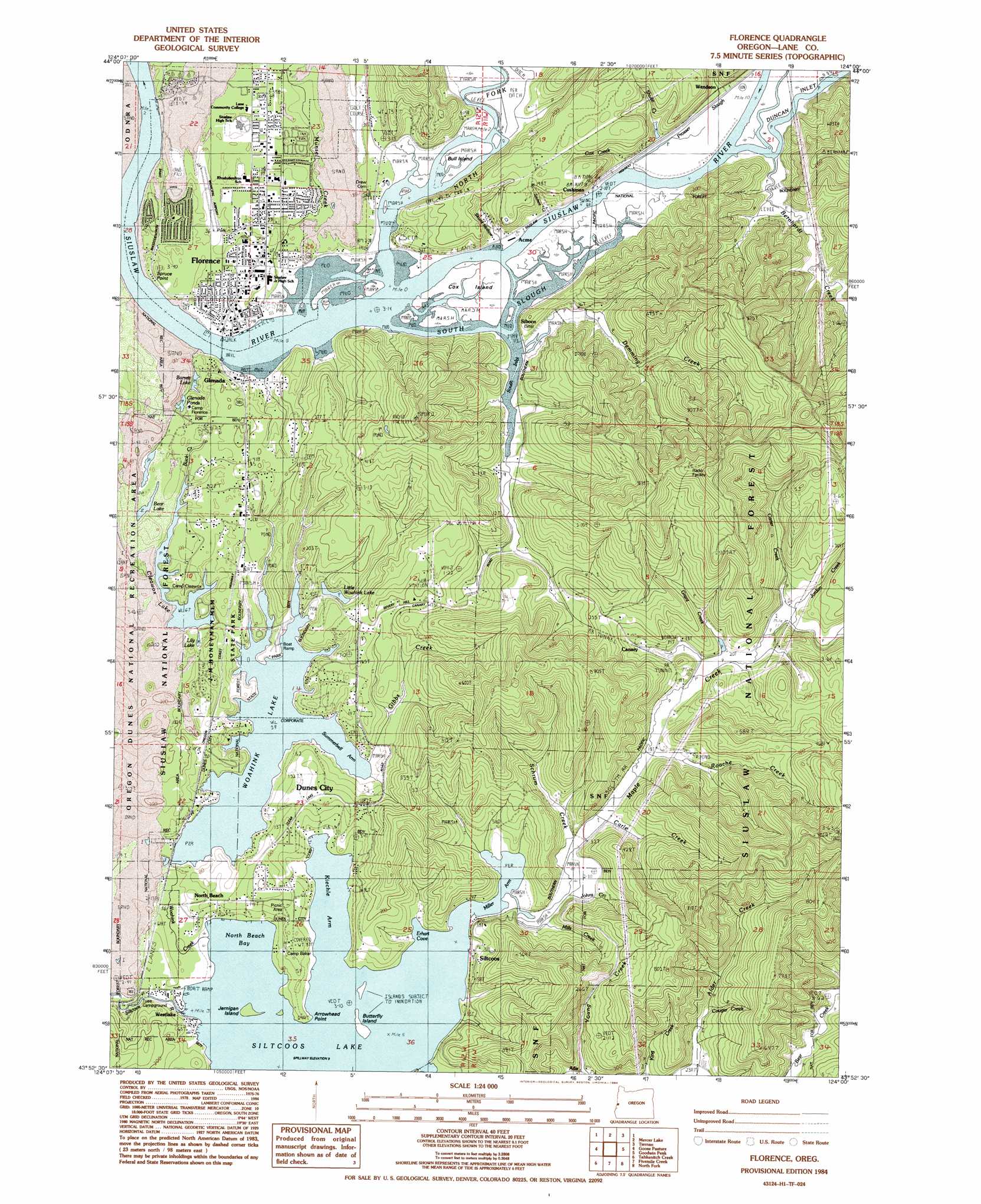
Florence Topo Map Oregon
To zoom in, hover over the map of Florence
USGS Topo Quad 43124h1 - 1:24,000 scale
| Topo Map Name: | Florence |
| USGS Topo Quad ID: | 43124h1 |
| Print Size: | ca. 21 1/4" wide x 27" high |
| Southeast Coordinates: | 43.875° N latitude / 124° W longitude |
| Map Center Coordinates: | 43.9375° N latitude / 124.0625° W longitude |
| U.S. State: | OR |
| Filename: | o43124h1.jpg |
| Download Map JPG Image: | Florence topo map 1:24,000 scale |
| Map Type: | Topographic |
| Topo Series: | 7.5´ |
| Map Scale: | 1:24,000 |
| Source of Map Images: | United States Geological Survey (USGS) |
| Alternate Map Versions: |
Florence OR 1984, updated 1984 Download PDF Buy paper map Florence OR 1984, updated 1984 Download PDF Buy paper map Florence OR 2011 Download PDF Buy paper map Florence OR 2014 Download PDF Buy paper map |
| FStopo: | US Forest Service topo Florence is available: Download FStopo PDF Download FStopo TIF |
1:24,000 Topo Quads surrounding Florence
Heceta Head |
Cummins Peak |
Herman Creek |
||
Mercer Lake |
Tiernan |
Mapleton |
||
Goose Pasture |
Florence |
Goodwin Peak |
Baldy Mountain |
|
Tahkenitch Creek |
Fivemile Creek |
North Fork |
Smith River Falls |
|
Winchester Bay |
Reedsport |
Deer Head Point |
Scottsburg |
> Back to 43124e1 at 1:100,000 scale
> Back to 43124a1 at 1:250,000 scale
> Back to U.S. Topo Maps home
Florence topo map: Gazetteer
Florence: Airports
Florence Municipal Airport elevation 13m 42′Florence: Bars
North Fork Shoal elevation 0m 0′Florence: Bays
Erhart Cove elevation 4m 13′Kiechle Arm elevation 4m 13′
Miller Arm elevation 4m 13′
North Beach Bay elevation 4m 13′
South Inlet elevation 0m 0′
Summerbell Arm Woahink Lake elevation 13m 42′
Florence: Capes
Arrowhead Point elevation 9m 29′Spruce Point elevation 7m 22′
Florence: Guts
Prosser Slough elevation 11m 36′South Slough elevation 0m 0′
Florence: Islands
Bull Island elevation 1m 3′Butterfly Island elevation 4m 13′
Cox Island elevation 1m 3′
Jernigan Island elevation 4m 13′
Florence: Lakes
Barrette Lake elevation 13m 42′Bear Lake elevation 35m 114′
Cleawox Lake elevation 21m 68′
Glenada Ponds elevation 36m 118′
Lilly Lake elevation 34m 111′
Little North Woahink Lake elevation 13m 42′
Siltcoos Lake elevation 4m 13′
Woahink Lake elevation 13m 42′
Florence: Parks
Jessie M Honeyman Memorial State Park elevation 20m 65′Joaquin Miller State Park elevation 54m 177′
Munsel Creek County Park elevation 21m 68′
Pritchard State Park elevation 3m 9′
Westlake County Park elevation 7m 22′
Florence: Populated Places
Acme elevation 22m 72′Canary elevation 22m 72′
Cushman elevation 7m 22′
Dunes City elevation 8m 26′
Florence elevation 14m 45′
Glenada elevation 18m 59′
North Beach elevation 9m 29′
Siltcoos elevation 22m 72′
Westlake elevation 8m 26′
Florence: Post Offices
Acme Post Office (historical) elevation 22m 72′Alene Post Office (historical) elevation 40m 131′
Canary Post Office (historical) elevation 22m 72′
Cushman Post Office (historical) elevation 7m 22′
Florence Post Office elevation 14m 45′
Glenada Post Office (historical) elevation 18m 59′
Siltcoos Post Office (historical) elevation 22m 72′
Westlake Post Office elevation 8m 26′
Florence: Reservoirs
Mount Canary Company Log Pond elevation 10m 32′Florence: Springs
Pier Point Spring elevation 4m 13′Florence: Streams
Bernhardt Creek elevation 8m 26′Buck Creek elevation 24m 78′
Carle Creek elevation 7m 22′
Carter Creek elevation 10m 32′
Cougar Creek elevation 61m 200′
Cox Creek elevation 5m 16′
Deer Creek elevation 13m 42′
Demming Creek elevation 2m 6′
Flint Creek elevation 0m 0′
Grant Creek elevation 9m 29′
Johns Creek elevation 5m 16′
Jordan Creek elevation 8m 26′
Maple Creek elevation 4m 13′
Miller Creek elevation 13m 42′
Mills Creek elevation 6m 19′
Munsel Creek elevation 0m 0′
North Fork Siuslaw River elevation 0m 0′
Roache Creek elevation 6m 19′
Saubert Creek elevation 31m 101′
Schrum Creek elevation 7m 22′
Shulte Creek elevation 12m 39′
Skunk Creek elevation 0m 0′
Woahink Creek elevation 4m 13′
Florence: Valleys
Skunk Hollow elevation 3m 9′Wendson Canyon elevation 12m 39′
Florence digital topo map on disk
Buy this Florence topo map showing relief, roads, GPS coordinates and other geographical features, as a high-resolution digital map file on DVD: