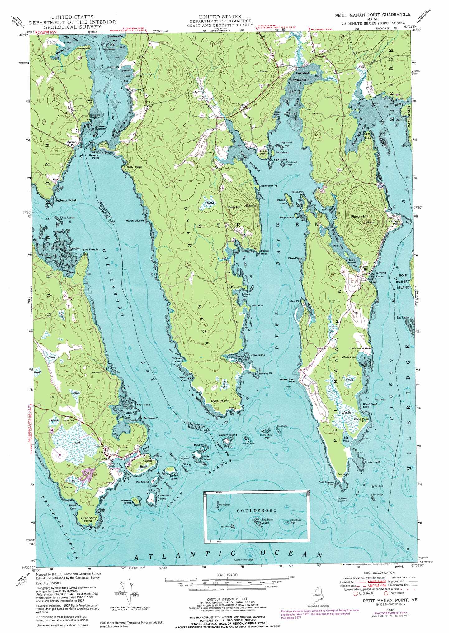
Petit Manan Point Topo Map Maine
To zoom in, hover over the map of Petit Manan Point
USGS Topo Quad 44067d8 - 1:24,000 scale
| Topo Map Name: | Petit Manan Point |
| USGS Topo Quad ID: | 44067d8 |
| Print Size: | ca. 21 1/4" wide x 27" high |
| Southeast Coordinates: | 44.375° N latitude / 67.875° W longitude |
| Map Center Coordinates: | 44.4375° N latitude / 67.9375° W longitude |
| U.S. State: | ME |
| Filename: | o44067d8.jpg |
| Download Map JPG Image: | Petit Manan Point topo map 1:24,000 scale |
| Map Type: | Topographic |
| Topo Series: | 7.5´ |
| Map Scale: | 1:24,000 |
| Source of Map Images: | United States Geological Survey (USGS) |
| Alternate Map Versions: |
Petit Manan ME 1948, updated 1970 Download PDF Buy paper map Petit Manan Point ME 1948, updated 1978 Download PDF Buy paper map Petit Manan Point ME 1948, updated 1978 Download PDF Buy paper map Petit Manan ME 1950 Download PDF Buy paper map Petit Manan Point ME 2011 Download PDF Buy paper map Petit Manan Point ME 2014 Download PDF Buy paper map |
1:24,000 Topo Quads surrounding Petit Manan Point
Molasses Pond |
Tunk Mountain |
Schoodic Lake |
Epping |
Columbia Falls |
Sullivan |
Tunk Lake |
Cherryfield |
Harrington |
Addison |
Bar Harbor |
Winter Harbor |
Petit Manan Point |
Bois Bubert |
Drisko Island |
Seal Harbor |
Schoodic Head |
|||
Baker Island |
> Back to 44067a1 at 1:100,000 scale
> Back to 44066a1 at 1:250,000 scale
> Back to U.S. Topo Maps home
Petit Manan Point topo map: Gazetteer
Petit Manan Point: Bars
Bar Ledge elevation 0m 0′Bay Ledge elevation 0m 0′
Big Ledge elevation 0m 0′
Bonny Chess Ledge elevation 0m 0′
Bunker Reef elevation 0m 0′
Fish Island Ledge elevation 0m 0′
Inner Bar elevation 0m 0′
Little Ledge elevation 0m 0′
Old Bull elevation 0m 0′
Outer Bar elevation 0m 0′
Petit Manan Bar elevation 0m 0′
Pop Island Ledge elevation 0m 0′
Shag Ledge elevation 0m 0′
Stone Horse Ledge elevation 0m 0′
Weir Ledges elevation 0m 0′
Petit Manan Point: Bays
Canes Cove elevation 0m 0′Carrying Place Cove elevation 0m 0′
Clay Cove elevation 0m 0′
Corea Harbor elevation 0m 0′
Dyer Bay elevation 0m 0′
Dyer Harbor elevation 0m 0′
Gouldsboro Bay elevation 0m 0′
Joy Bay elevation 0m 0′
Joy Cove elevation 0m 0′
Lobster Cove elevation 1m 3′
Long Mill Cove elevation 0m 0′
Newman Cove elevation 0m 0′
Over Cove elevation 0m 0′
Parrit Cove elevation 0m 0′
Pigeon Hill Bay elevation 0m 0′
Pigeon Hill Cove elevation 0m 0′
Pinkham Bay elevation 0m 0′
Sand Cove elevation 1m 3′
Schooner Cove elevation 0m 0′
Shark Cove elevation 0m 0′
Smelt Brook elevation 6m 19′
Stanley Cove elevation 0m 0′
Wood Pond Cove elevation 0m 0′
Yeaton Cove elevation 0m 0′
Petit Manan Point: Capes
Birch Point elevation 2m 6′Chair Pond Head elevation 7m 22′
Chitman Point elevation 5m 16′
Clam Point elevation 0m 0′
Cranberry Point elevation 0m 0′
Dolly Head elevation 7m 22′
Dyer Neck elevation 26m 85′
Dyer Point elevation 3m 9′
Garden Point elevation 7m 22′
Goods Point elevation 1m 3′
Jetteau Point elevation 4m 13′
Marsh Cove Point elevation 2m 6′
Over Point elevation 0m 0′
Parker Head elevation 4m 13′
Parrit Point elevation 1m 3′
Petit Manan Point elevation 0m 0′
Point Francis elevation 2m 6′
Rogers Point elevation 9m 29′
Sampson Point elevation 1m 3′
Schooner Point elevation 0m 0′
Spar Point elevation 5m 16′
Stanley Point elevation 0m 0′
Stevens Point elevation 8m 26′
Val Point elevation 0m 0′
Wall Point elevation 2m 6′
Wood Pond Point elevation 0m 0′
Yeaton Point elevation 0m 0′
Yellow Birch Head elevation 13m 42′
Youngs Point elevation 1m 3′
Petit Manan Point: Channels
Eastern Way elevation 0m 0′Frazer Passage elevation 0m 0′
The Narrows elevation 0m 0′
Western Passage elevation 0m 0′
Petit Manan Point: Islands
Abbott Island elevation 0m 0′Bald Rock elevation 0m 0′
Bar Island elevation 0m 0′
Crow Island elevation 0m 0′
Dry Island elevation 0m 0′
Eastern Island elevation 6m 19′
Fish Island elevation 0m 0′
Hog Island elevation 0m 0′
Lobster Island elevation 0m 0′
Outer Bar Island elevation 0m 0′
Pop Island elevation 0m 0′
Sally Island elevation 0m 0′
Sally Island elevation 0m 0′
Sally Islands elevation 0m 0′
Sheep Island elevation 8m 26′
Sheep Island elevation 3m 9′
Southwest Breaker elevation 0m 0′
The Castle elevation 0m 0′
Western Island elevation 5m 16′
Petit Manan Point: Lakes
Big Pond elevation 1m 3′Chair Pond elevation 1m 3′
Petit Manan Point: Parks
Petit Manan National Wildlife Refuge elevation 23m 75′Petit Manan Point: Populated Places
Corea elevation 8m 26′Pigeon Hill elevation 3m 9′
Petit Manan Point: Post Offices
Corea Post Office elevation 9m 29′Petit Manan Point: Streams
Bobby Creek elevation 0m 0′Tucker Creek elevation 0m 0′
Petit Manan Point: Summits
Eagle Hill elevation 69m 226′Pigeon Hill elevation 94m 308′
Petit Manan Point digital topo map on disk
Buy this Petit Manan Point topo map showing relief, roads, GPS coordinates and other geographical features, as a high-resolution digital map file on DVD:
Maine, New Hampshire, Rhode Island & Eastern Massachusetts
Buy digital topo maps: Maine, New Hampshire, Rhode Island & Eastern Massachusetts