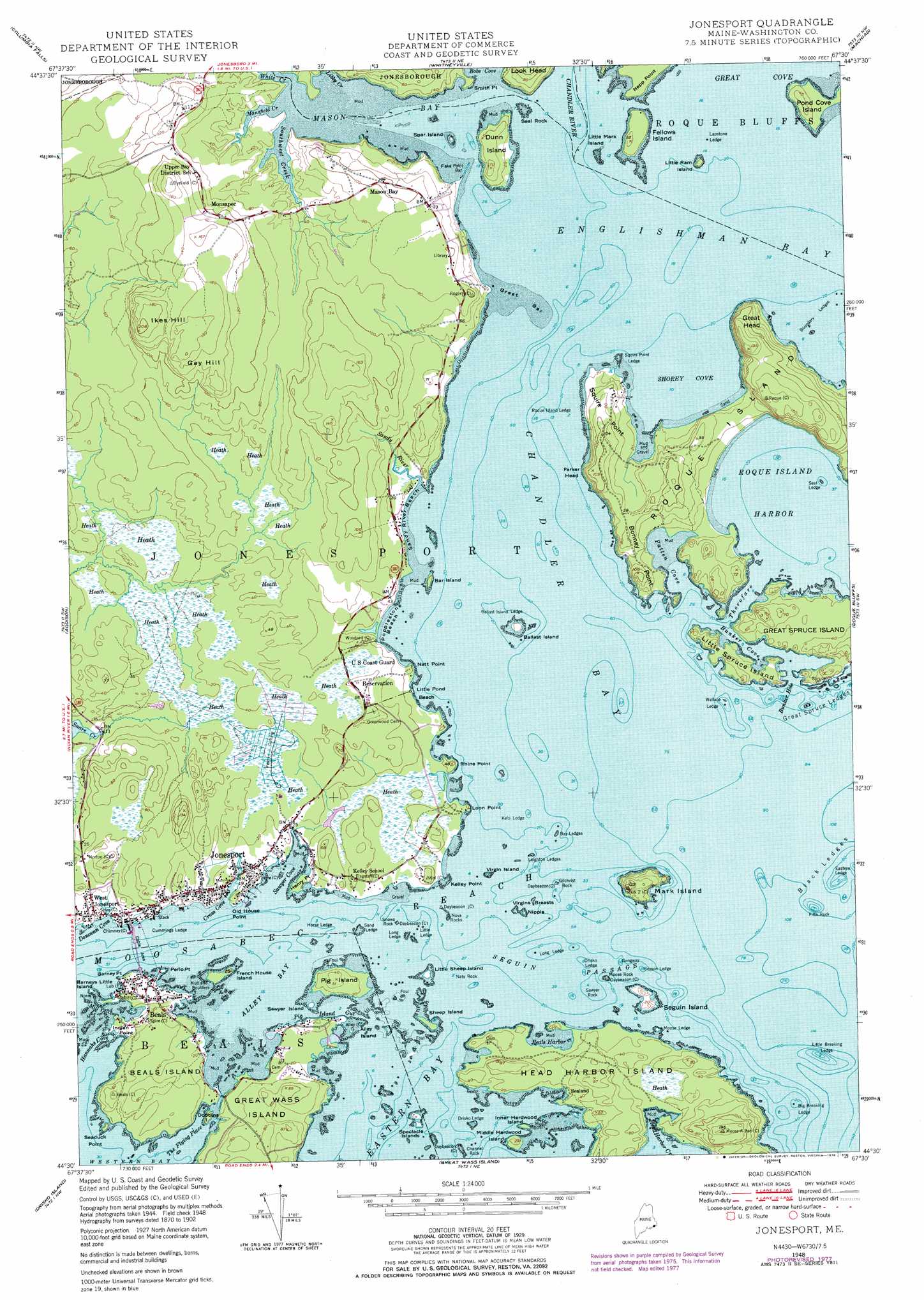
Jonesport Topo Map Maine
To zoom in, hover over the map of Jonesport
USGS Topo Quad 44067e5 - 1:24,000 scale
| Topo Map Name: | Jonesport |
| USGS Topo Quad ID: | 44067e5 |
| Print Size: | ca. 21 1/4" wide x 27" high |
| Southeast Coordinates: | 44.5° N latitude / 67.5° W longitude |
| Map Center Coordinates: | 44.5625° N latitude / 67.5625° W longitude |
| U.S. State: | ME |
| Filename: | o44067e5.jpg |
| Download Map JPG Image: | Jonesport topo map 1:24,000 scale |
| Map Type: | Topographic |
| Topo Series: | 7.5´ |
| Map Scale: | 1:24,000 |
| Source of Map Images: | United States Geological Survey (USGS) |
| Alternate Map Versions: |
Jonesport ME 1948, updated 1965 Download PDF Buy paper map Jonesport ME 1948, updated 1978 Download PDF Buy paper map Jonesport ME 1948, updated 1978 Download PDF Buy paper map Jonesport ME 1951 Download PDF Buy paper map Jonesport ME 1951 Download PDF Buy paper map Jonesport ME 2011 Download PDF Buy paper map Jonesport ME 2014 Download PDF Buy paper map |
1:24,000 Topo Quads surrounding Jonesport
Montegail Pond |
Peaked Mountain Pond |
Bog Lake |
Hadley Lake |
Long Lake |
Epping |
Columbia Falls |
Whitneyville |
Machias |
Machias Bay |
Harrington |
Addison |
Jonesport |
Roque Bluffs |
Cross Island |
Bois Bubert |
Drisko Island |
Great Wass Island |
||
> Back to 44067e1 at 1:100,000 scale
> Back to 44066a1 at 1:250,000 scale
> Back to U.S. Topo Maps home
Jonesport topo map: Gazetteer
Jonesport: Bars
Bay Ledges elevation 0m 0′Big Breaking Ledge elevation 0m 0′
Boundary Ledges elevation 0m 0′
Cummings Ledge elevation 0m 0′
Drisko Ledge elevation 0m 0′
Drisko Ledge elevation 0m 0′
Eastern Ledge elevation 0m 0′
Flake Point Bar elevation 1m 3′
Gangway elevation 0m 0′
Great Bar elevation 1m 3′
Great Spruce Ledges elevation 0m 0′
Horse Ledge elevation 0m 0′
Horse Ledge elevation 0m 0′
Kelp Ledge elevation 0m 0′
Lapstone Ledge elevation 0m 0′
Leighton Ledges elevation 0m 0′
Little Breaking Ledge elevation 0m 0′
Little Ledge elevation 0m 0′
Long Ledge elevation 0m 0′
Long Ledge elevation 0m 0′
Moose Ledge elevation 1m 3′
Sand Ledge elevation 0m 0′
Sawyer Rock elevation 0m 0′
Seal Ledge elevation 0m 0′
Seguin Ledge elevation 0m 0′
Squire Point Ledge elevation 0m 0′
Wallace Ledge elevation 0m 0′
Jonesport: Bays
Alley Bay elevation 0m 0′Beals Harbor elevation -2m -7′
Boat Cove elevation 1m 3′
Bunker Cove elevation 9m 29′
Bunker Hole elevation 0m 0′
Chandler Bay elevation 0m 0′
Cranberry Cove elevation 0m 0′
Cross Cove elevation 5m 16′
Donovan Cove elevation 4m 13′
Hannahs Cove elevation 0m 0′
Mason Bay elevation 0m 0′
Mill Pond elevation 0m 0′
Patten Cove elevation 0m 0′
Roque Island Harbor elevation 0m 0′
Sawyer Cove elevation 0m 0′
Shorey Cove elevation 0m 0′
The Flying Place elevation 0m 0′
Jonesport: Beaches
Ballast Island Ledge elevation 0m 0′Great Beach elevation 0m 0′
Little Pond Beach elevation 4m 13′
Pobblestone Cove elevation 0m 0′
Roque Island Ledge elevation 0m 0′
Sandy River Beach elevation 0m 0′
Jonesport: Capes
Barney Point elevation 7m 22′Bonney Point elevation 27m 88′
Henry Point elevation 0m 0′
Indian Point elevation 7m 22′
Kelley Point elevation 1m 3′
Loon Point elevation 1m 3′
Natt Point elevation 0m 0′
Nepp Point elevation 1m 3′
Old House Point elevation 6m 19′
Perio Point elevation 0m 0′
Rhine Point elevation 0m 0′
Seaduck Point elevation 1m 3′
Smith Point elevation 0m 0′
Squire Point elevation 25m 82′
Jonesport: Channels
Moosabec Reach elevation 0m 0′Seguin Passage elevation 0m 0′
Thorofare elevation 0m 0′
Jonesport: Cliffs
Great Head elevation 46m 150′Parker Head elevation 26m 85′
Jonesport: Dams
Snare Creek Dam elevation 5m 16′Jonesport: Guts
Pig Island Gut elevation 0m 0′Jonesport: Islands
Alley Island elevation 5m 16′Ballast Island elevation 4m 13′
Bar Island elevation 4m 13′
Barneys Little Island elevation 0m 0′
Beals Island elevation 12m 39′
Dobbins Island elevation 0m 0′
Dunn Island elevation 6m 19′
East Bar Island elevation 9m 29′
Fellows Island elevation 7m 22′
Fifth Rock elevation 0m 0′
French House Island elevation 1m 3′
Gilchrist Rock elevation 0m 0′
Great Spruce Island elevation 10m 32′
Head Harbor Island elevation 4m 13′
Inner Hardwood Island elevation 0m 0′
Little Mark Island elevation 0m 0′
Little Ram Island elevation 2m 6′
Little Sheep Island elevation 0m 0′
Little Spruce Island elevation 12m 39′
Mark Island elevation 24m 78′
Middle Hardwood Island elevation 7m 22′
Moose Rock elevation 0m 0′
Nats Rock elevation 0m 0′
Nipple elevation 0m 0′
Nova Rocks elevation 0m 0′
Pig Island elevation 13m 42′
Pond Cove Island elevation 4m 13′
Roque Island elevation 21m 68′
Sawyer Island elevation 0m 0′
Seal Rock elevation 0m 0′
Seguin Island elevation 8m 26′
Sheep Island elevation 0m 0′
Snows Rock elevation 0m 0′
Spar Island elevation 0m 0′
Spectacle Islands elevation 0m 0′
Virgin Island elevation 0m 0′
Virgins Breasts elevation 0m 0′
West Bar Island elevation 12m 39′
West Black Rock elevation 0m 0′
Jonesport: Populated Places
Beals elevation 12m 39′Jonesport elevation 0m 0′
Monsapec elevation 33m 108′
Sealand elevation 4m 13′
West Jonesport elevation 7m 22′
Jonesport: Reservoirs
Snare Creek elevation 5m 16′Jonesport: Streams
Chandler River elevation 0m 0′Head Harbor Creek elevation 0m 0′
Libby Creek elevation 0m 0′
Mansfield Creek elevation 0m 0′
Sandy River elevation 3m 9′
Southwest Creek elevation 0m 0′
White Creek elevation -2m -7′
Jonesport: Summits
Channel Rock elevation 0m 0′Gay Hill elevation 61m 200′
Ikes Hill elevation 61m 200′
Jonesport digital topo map on disk
Buy this Jonesport topo map showing relief, roads, GPS coordinates and other geographical features, as a high-resolution digital map file on DVD:
Maine, New Hampshire, Rhode Island & Eastern Massachusetts
Buy digital topo maps: Maine, New Hampshire, Rhode Island & Eastern Massachusetts