Harrington Topo Map Maine
To zoom in, hover over the map of Harrington
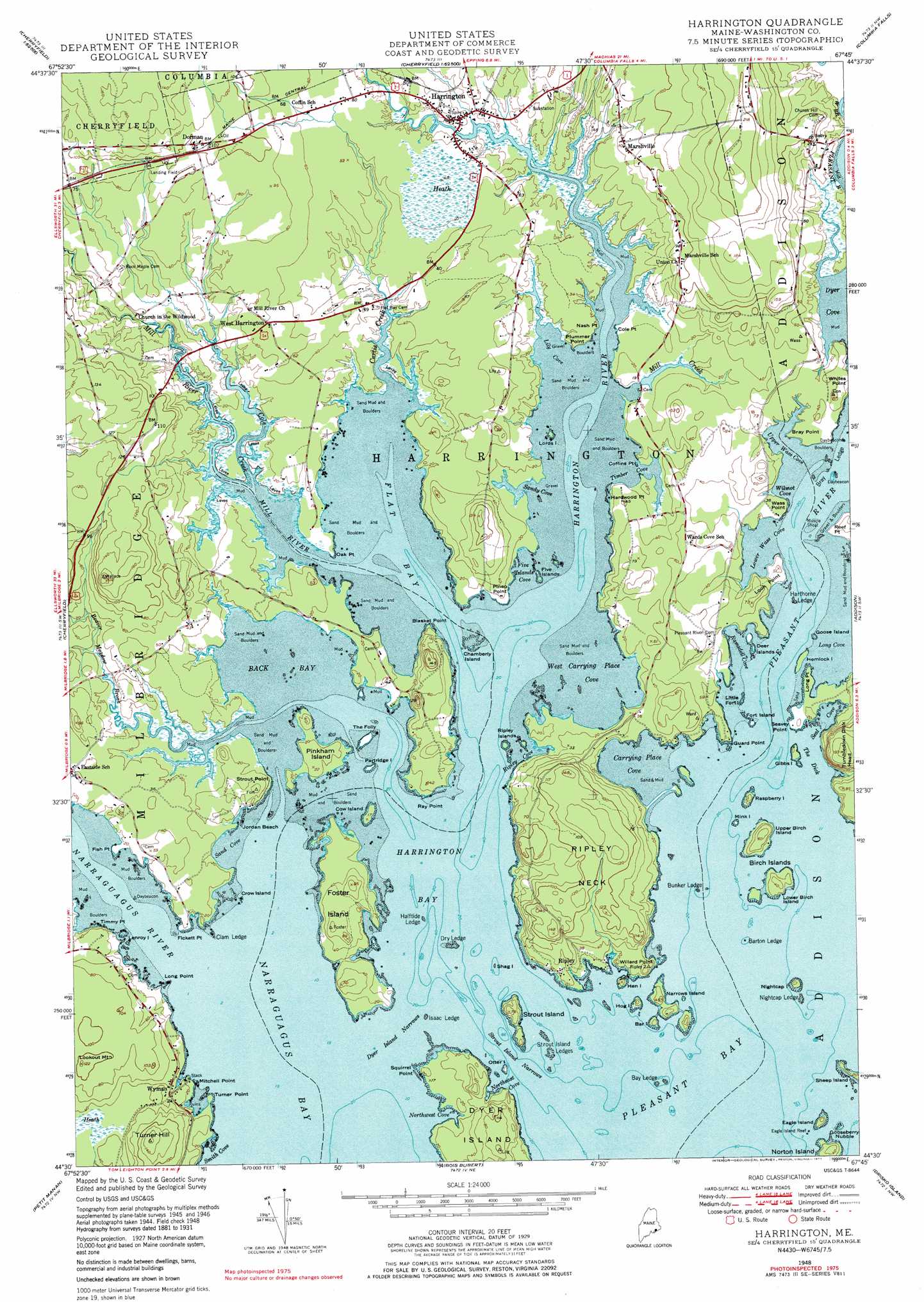
USGS Topo Quad 44067e7 - 1:24,000 scale
| Topo Map Name: | Harrington |
| USGS Topo Quad ID: | 44067e7 |
| Print Size: | ca. 21 1/4" wide x 27" high |
| Southeast Coordinates: | 44.5° N latitude / 67.75° W longitude |
| Map Center Coordinates: | 44.5625° N latitude / 67.8125° W longitude |
| U.S. State: | ME |
| Filename: | o44067e7.jpg |
| Download Map JPG Image: | Harrington topo map 1:24,000 scale |
| Map Type: | Topographic |
| Topo Series: | 7.5´ |
| Map Scale: | 1:24,000 |
| Source of Map Images: | United States Geological Survey (USGS) |
| Alternate Map Versions: |
Harrington ME 1948, updated 1971 Download PDF Buy paper map Harrington ME 1948, updated 1977 Download PDF Buy paper map Harrington ME 1951 Download PDF Buy paper map Harrington ME 1951 Download PDF Buy paper map Harrington ME 2011 Download PDF Buy paper map Harrington ME 2014 Download PDF Buy paper map |
1:24,000 Topo Quads surrounding Harrington
Lead Mountain |
Northeast Bluff |
Montegail Pond |
Peaked Mountain Pond |
Bog Lake |
Tunk Mountain |
Schoodic Lake |
Epping |
Columbia Falls |
Whitneyville |
Tunk Lake |
Cherryfield |
Harrington |
Addison |
Jonesport |
Winter Harbor |
Petit Manan Point |
Bois Bubert |
Drisko Island |
Great Wass Island |
Schoodic Head |
> Back to 44067e1 at 1:100,000 scale
> Back to 44066a1 at 1:250,000 scale
> Back to U.S. Topo Maps home
Harrington topo map: Gazetteer
Harrington: Bars
Barton Ledge elevation 0m 0′Bay Ledge elevation 0m 0′
Bray Ledge elevation 0m 0′
Bunker Ledge elevation 0m 0′
Clam Ledge elevation 0m 0′
Dry Ledge elevation 0m 0′
Dyer Cove elevation 0m 0′
Eagle Island Reef elevation 0m 0′
Halftide Ledge elevation 0m 0′
Harthorne Ledge elevation 0m 0′
Isaac Ledge elevation 0m 0′
Muscle Shoal elevation 0m 0′
Nightcap Ledge elevation 0m 0′
Strout Island Ledges elevation 0m 0′
Harrington: Bays
Back Bay elevation 0m 0′Carrying Place Cove elevation 0m 0′
Five Islands Cove elevation 0m 0′
Flat Bay elevation 0m 0′
Harrington Bay elevation 0m 0′
Lily Cove elevation 0m 0′
Lower Wass Cove elevation 0m 0′
Narraguagus Bay elevation 0m 0′
Northeast Cove elevation 0m 0′
Northwest Cove elevation 0m 0′
Pleasant Bay elevation 0m 0′
Ramsdell Cove elevation 0m 0′
Ripley Cove elevation 0m 0′
Sand Cove elevation 6m 19′
Sandy Cove elevation 0m 0′
Seal Cove elevation 0m 0′
Smith Cove elevation 1m 3′
Timber Cove elevation 0m 0′
Upper Wass Cove elevation 0m 0′
West Carrying Place Cove elevation 0m 0′
Wilmot Cove elevation 0m 0′
Harrington: Beaches
Jordan Beach elevation 1m 3′Harrington: Capes
Blasket Point elevation 4m 13′Bray Point elevation 9m 29′
Coffins Point elevation 0m 0′
Cole Point elevation 1m 3′
Fickett Point elevation 1m 3′
Fish Point elevation 0m 0′
Guard Point elevation 2m 6′
Hardwood Point elevation 1m 3′
Long Point elevation 0m 0′
Long Point elevation 0m 0′
Look Point elevation 13m 42′
Mitchell Point elevation 0m 0′
Nash Point elevation 0m 0′
Oak Point elevation 0m 0′
Pineo Point elevation 3m 9′
Plummer Point elevation 0m 0′
Ray Point elevation 1m 3′
Ripley Neck elevation 26m 85′
Seavey Point elevation 3m 9′
Squirrel Point elevation 0m 0′
Strout Point elevation 13m 42′
Timmy Point elevation 12m 39′
Turner Point elevation 1m 3′
Wass Point elevation 7m 22′
Willard Point elevation 17m 55′
Harrington: Channels
Dyer Island Narrows elevation 0m 0′Strout Island Narrows elevation 0m 0′
The Dick elevation 0m 0′
Harrington: Islands
Bar Island elevation 8m 26′Birch Islands elevation 0m 0′
Chamberly Island elevation 0m 0′
Channel Rock elevation 0m 0′
Cow Island elevation 1m 3′
Cranberry Island (historical) elevation 5m 16′
Crow Island elevation 0m 0′
Deer Island elevation 6m 19′
Eagle Island elevation 5m 16′
Five Island elevation 0m 0′
Fort Island elevation 0m 0′
Foster Island elevation 21m 68′
Gibbs Island elevation 1m 3′
Goose Island elevation 0m 0′
Gooseberry Nubble elevation 0m 0′
Hemlock Island elevation 0m 0′
Hen Island elevation 8m 26′
Hog Island elevation 5m 16′
Lenroy Island elevation 0m 0′
Little Fort Island elevation 0m 0′
Lords Island elevation 0m 0′
Lower Birch Island elevation 13m 42′
Mink Island elevation 0m 0′
Narrows Island elevation 13m 42′
Nightcap elevation 12m 39′
Otter Island elevation 0m 0′
Partiridge Island elevation 0m 0′
Partridge Island elevation 0m 0′
Pinkham Island elevation 6m 19′
Raspberry Island elevation 8m 26′
Ripley Islands elevation 0m 0′
Shag Island elevation 0m 0′
Sheep Island elevation 5m 16′
Strout Island elevation 14m 45′
The Folly elevation 1m 3′
Upper Birch Island elevation 19m 62′
Harrington: Populated Places
Dorman elevation 34m 111′Harrington elevation 7m 22′
Marshville elevation 20m 65′
Ripley elevation 8m 26′
West Harrington elevation 24m 78′
Wyman elevation 10m 32′
Harrington: Streams
Beaver Meadow Brook elevation 0m 0′Cole Creek elevation 0m 0′
Curtis Creek elevation 0m 0′
Harrington River elevation 0m 0′
Mill Creek elevation 1m 3′
Mill River elevation 0m 0′
Narraguagus River elevation 0m 0′
Pleasant River elevation 0m 0′
Harrington: Summits
Lookout Mountain elevation 33m 108′Tumbledown Dick Head elevation 56m 183′
Turner Hill elevation 49m 160′
Harrington digital topo map on disk
Buy this Harrington topo map showing relief, roads, GPS coordinates and other geographical features, as a high-resolution digital map file on DVD:
Maine, New Hampshire, Rhode Island & Eastern Massachusetts
Buy digital topo maps: Maine, New Hampshire, Rhode Island & Eastern Massachusetts