Machias Bay Topo Map Maine
To zoom in, hover over the map of Machias Bay
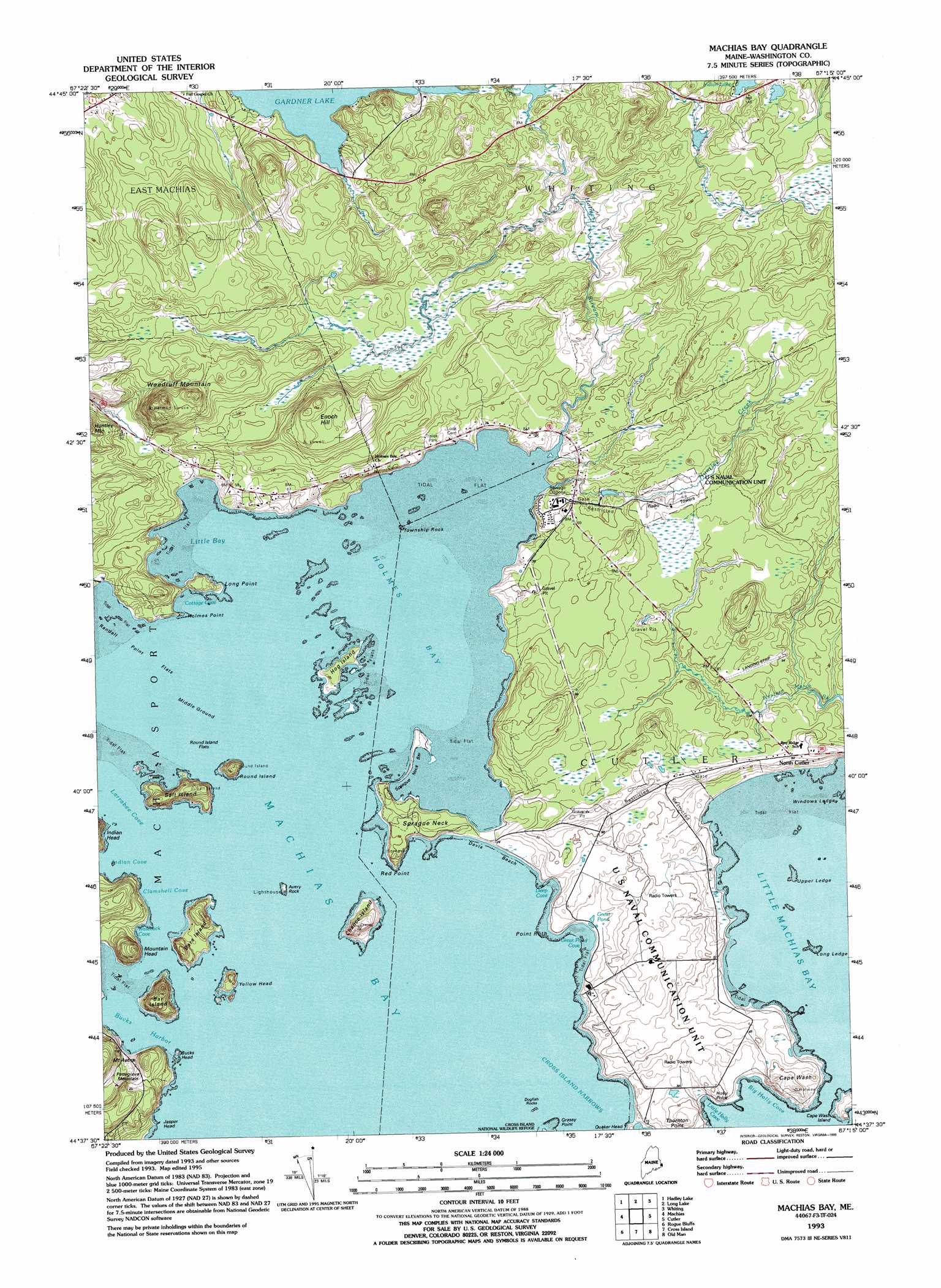
USGS Topo Quad 44067f3 - 1:24,000 scale
| Topo Map Name: | Machias Bay |
| USGS Topo Quad ID: | 44067f3 |
| Print Size: | ca. 21 1/4" wide x 27" high |
| Southeast Coordinates: | 44.625° N latitude / 67.25° W longitude |
| Map Center Coordinates: | 44.6875° N latitude / 67.3125° W longitude |
| U.S. State: | ME |
| Filename: | o44067f3.jpg |
| Download Map JPG Image: | Machias Bay topo map 1:24,000 scale |
| Map Type: | Topographic |
| Topo Series: | 7.5´ |
| Map Scale: | 1:24,000 |
| Source of Map Images: | United States Geological Survey (USGS) |
| Alternate Map Versions: |
Machias Bay ME 1949, updated 1974 Download PDF Buy paper map Machias Bay ME 1949, updated 1978 Download PDF Buy paper map Machias Bay ME 1951 Download PDF Buy paper map Machias Bay ME 1993, updated 1995 Download PDF Buy paper map Machias Bay ME 1993, updated 1995 Download PDF Buy paper map Machias Bay ME 2011 Download PDF Buy paper map Machias Bay ME 2014 Download PDF Buy paper map |
1:24,000 Topo Quads surrounding Machias Bay
Round Lake |
Lake Cathance |
Porcupine Mountain |
Pembroke |
Eastport |
Bog Lake |
Hadley Lake |
Long Lake |
Whiting |
West Lubec |
Whitneyville |
Machias |
Machias Bay |
Cutler |
Moose River |
Jonesport |
Roque Bluffs |
Cross Island |
||
Great Wass Island |
> Back to 44067e1 at 1:100,000 scale
> Back to 44066a1 at 1:250,000 scale
> Back to U.S. Topo Maps home
Machias Bay topo map: Gazetteer
Machias Bay: Airports
Ramsdell Field elevation 17m 55′Machias Bay: Bars
Long Ledge elevation 0m 0′Middle Ground elevation 0m 0′
Randall Point Flats elevation 0m 0′
Round Island Flats elevation 0m 0′
Sprague Neck Bar elevation 3m 9′
Upper Ledge elevation 0m 0′
Windows Ledge elevation 0m 0′
Machias Bay: Bays
Big Holly Cove elevation 0m 0′Bucks Harbor elevation 0m 0′
Clamshell Cove elevation 0m 0′
Cottage Cove elevation 0m 0′
Deep Cove elevation 2m 6′
Great Pond Cove elevation 0m 0′
Holmes Bay elevation 0m 0′
Indian Cove elevation 0m 0′
Larrabee Cove elevation 0m 0′
Little Bay elevation 0m 0′
Little Holly Cove elevation 0m 0′
Little Machias Bay elevation 0m 0′
Machias Bay elevation 0m 0′
Waleback Cove elevation 0m 0′
Machias Bay: Beaches
Davis Beach elevation 2m 6′Jasper Beach elevation 10m 32′
Machias Bay: Capes
Cape Wash elevation 17m 55′Grassy Point elevation 0m 0′
Holly Point elevation 10m 32′
Holmes Point elevation 7m 22′
Long Point elevation 7m 22′
Point Ruth elevation 1m 3′
Red Point elevation 9m 29′
Sprague Neck elevation 11m 36′
Machias Bay: Cliffs
Jasper Head elevation 0m 0′Machias Bay: Islands
Avery Rock elevation 10m 32′Bar Island elevation 41m 134′
Bare Island elevation 12m 39′
Bucks Head elevation 0m 0′
Cape Wash Island elevation 9m 29′
Chance Island elevation 31m 101′
Colbeth Rock elevation 0m 0′
Dogfish Rocks elevation 0m 0′
Hog Island elevation 6m 19′
Round Island elevation 0m 0′
Salt Island elevation 32m 104′
Township Rock elevation 0m 0′
Yellow Head elevation 19m 62′
Machias Bay: Lakes
Great Pond elevation 3m 9′Holmes Pond elevation 23m 75′
Machias Bay: Populated Places
North Cutler elevation 20m 65′Machias Bay: Streams
Holmes Stream elevation 3m 9′Huntley Creek elevation 0m 0′
Machias Bay: Summits
Enoch Hill elevation 65m 213′Mount Aetna elevation 43m 141′
Mountain Head elevation 63m 206′
Pettegrove Mountain elevation 48m 157′
Woodruff Mountain elevation 93m 305′
Machias Bay digital topo map on disk
Buy this Machias Bay topo map showing relief, roads, GPS coordinates and other geographical features, as a high-resolution digital map file on DVD:
Maine, New Hampshire, Rhode Island & Eastern Massachusetts
Buy digital topo maps: Maine, New Hampshire, Rhode Island & Eastern Massachusetts