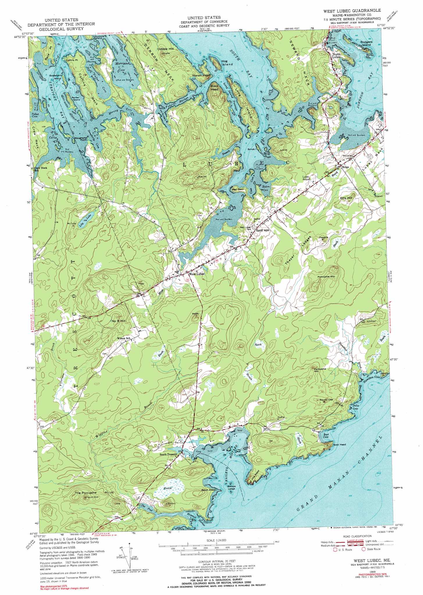
West Lubec Topo Map Maine
To zoom in, hover over the map of West Lubec
USGS Topo Quad 44067g1 - 1:24,000 scale
| Topo Map Name: | West Lubec |
| USGS Topo Quad ID: | 44067g1 |
| Print Size: | ca. 21 1/4" wide x 27" high |
| Southeast Coordinates: | 44.75° N latitude / 67° W longitude |
| Map Center Coordinates: | 44.8125° N latitude / 67.0625° W longitude |
| U.S. State: | ME |
| Filename: | o44067g1.jpg |
| Download Map JPG Image: | West Lubec topo map 1:24,000 scale |
| Map Type: | Topographic |
| Topo Series: | 7.5´ |
| Map Scale: | 1:24,000 |
| Source of Map Images: | United States Geological Survey (USGS) |
| Alternate Map Versions: |
West Lubec ME 1949, updated 1967 Download PDF Buy paper map West Lubec ME 1949, updated 1972 Download PDF Buy paper map West Lubec ME 1949, updated 1991 Download PDF Buy paper map West Lubec ME 1951 Download PDF Buy paper map West Lubec ME 2011 Download PDF Buy paper map West Lubec ME 2014 Download PDF Buy paper map |
1:24,000 Topo Quads surrounding West Lubec
Meddybemp Lake East |
Red Beach |
Robbinston |
Porcupine Mountain |
|
Pembroke |
Eastport |
Long Lake |
Whiting |
|
West Lubec |
Lubec |
Machias Bay |
Cutler |
Moose River |
Cross Island |
> Back to 44067e1 at 1:100,000 scale
> Back to 44066a1 at 1:250,000 scale
> Back to U.S. Topo Maps home
West Lubec topo map: Gazetteer
West Lubec: Airports
Lubec Municipal Airport elevation 24m 78′West Lubec: Bays
Baileys Ledge elevation 0m 0′Baileys Mistake elevation 0m 0′
Boot Cove elevation 1m 3′
Carlos Cove elevation 0m 0′
Case Cove elevation 0m 0′
Dougherty Cove elevation 0m 0′
Eaton Cove elevation 0m 0′
Federal Harbor elevation 14m 45′
Hamilton Cove elevation 5m 16′
Haycock Harbor elevation 0m 0′
Johnson Bay elevation 0m 0′
Julia Cove elevation 2m 6′
Morong Cove elevation 6m 19′
Morrison Cove elevation 0m 0′
Nutter Cove elevation 0m 0′
Straight Bay elevation 0m 0′
Talbot Cove elevation 0m 0′
The Pool elevation 0m 0′
West Lubec: Capes
Coffins Neck elevation 17m 55′Coffins Point elevation 5m 16′
Denbow Neck elevation 17m 55′
Dougherty Point elevation 0m 0′
Race Point elevation 18m 59′
Red Point elevation 14m 45′
West Lubec: Channels
Long Island Passage elevation 0m 0′West Lubec: Cliffs
Black Head elevation 20m 65′West Lubec: Islands
Gooseberry Island elevation 2m 6′Guvspuny Island elevation 8m 26′
Hog Island elevation 30m 98′
Long Island elevation 31m 101′
Parker Island elevation 13m 42′
Rodgers Island elevation 28m 91′
Scrub Island elevation 7m 22′
West Lubec: Lakes
Lily Lake elevation 32m 104′West Lubec: Populated Places
North Lubec elevation 24m 78′Ridge elevation 27m 88′
South Trescott elevation 7m 22′
Split Hill elevation 43m 141′
West Lubec elevation 19m 62′
West Lubec: Streams
Bassett Creek elevation 5m 16′Hamilton Brook elevation 2m 6′
Mays Brook elevation 1m 3′
Wiggins Brook elevation 5m 16′
West Lubec: Summits
Batch Head elevation 39m 127′Boot Head elevation 46m 150′
Christmas Tree Mountain elevation 65m 213′
Cobble Hill elevation 45m 147′
Ellis Hill elevation 43m 141′
Horan Head elevation 39m 127′
Jims Head elevation 38m 124′
Number Nine Hill elevation 74m 242′
Porcupine Hill elevation 63m 206′
Porcupine Mountain elevation 74m 242′
Thayer Ledges elevation 36m 118′
The Crows Nest elevation 65m 213′
The Porcupine elevation 78m 255′
West Lubec digital topo map on disk
Buy this West Lubec topo map showing relief, roads, GPS coordinates and other geographical features, as a high-resolution digital map file on DVD:
Maine, New Hampshire, Rhode Island & Eastern Massachusetts
Buy digital topo maps: Maine, New Hampshire, Rhode Island & Eastern Massachusetts