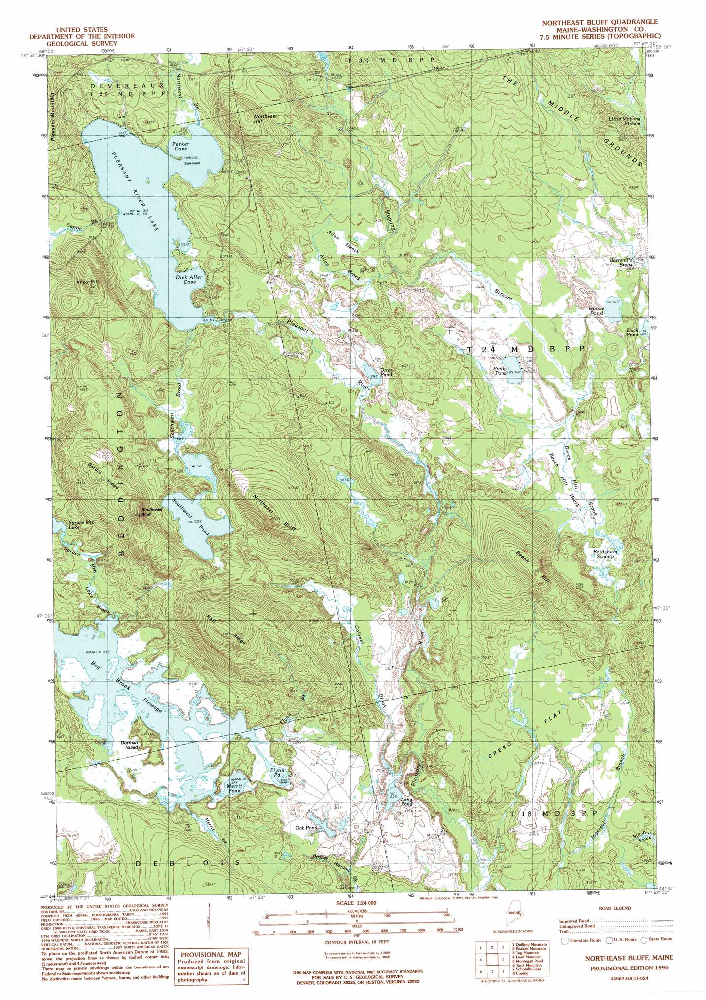
Northeast Bluff Topo Map Maine
To zoom in, hover over the map of Northeast Bluff
USGS Topo Quad 44067g8 - 1:24,000 scale
| Topo Map Name: | Northeast Bluff |
| USGS Topo Quad ID: | 44067g8 |
| Print Size: | ca. 21 1/4" wide x 27" high |
| Southeast Coordinates: | 44.75° N latitude / 67.875° W longitude |
| Map Center Coordinates: | 44.8125° N latitude / 67.9375° W longitude |
| U.S. State: | ME |
| Filename: | o44067g8.jpg |
| Download Map JPG Image: | Northeast Bluff topo map 1:24,000 scale |
| Map Type: | Topographic |
| Topo Series: | 7.5´ |
| Map Scale: | 1:24,000 |
| Source of Map Images: | United States Geological Survey (USGS) |
| Alternate Map Versions: |
Northeast Bluff ME 1990, updated 1990 Download PDF Buy paper map Northeast Bluff ME 2011 Download PDF Buy paper map Northeast Bluff ME 2014 Download PDF Buy paper map |
1:24,000 Topo Quads surrounding Northeast Bluff
West Lake |
Gassabias Lake |
Fletcher Peak |
Monroe Lake |
Clifford Lake |
Alligator Lake |
Quillpig Mountain |
Peaked Mountain |
Tug Mountain |
Wesley |
Rocky Pond |
Lead Mountain |
Northeast Bluff |
Montegail Pond |
Peaked Mountain Pond |
Molasses Pond |
Tunk Mountain |
Schoodic Lake |
Epping |
Columbia Falls |
Sullivan |
Tunk Lake |
Cherryfield |
Harrington |
Addison |
> Back to 44067e1 at 1:100,000 scale
> Back to 44066a1 at 1:250,000 scale
> Back to U.S. Topo Maps home
Northeast Bluff topo map: Gazetteer
Northeast Bluff: Bays
Dick Allen Cove elevation 97m 318′Parker Cove elevation 97m 318′
Northeast Bluff: Capes
Elsie Point elevation 97m 318′Northeast Bluff: Cliffs
Northeast Bluff elevation 173m 567′Southwest Bluff elevation 200m 656′
Northeast Bluff: Dams
Pleasant River Lake Water Dam elevation 97m 318′Northeast Bluff: Flats
Crebo Flat elevation 82m 269′Northeast Bluff: Islands
Dorman Island elevation 84m 275′Northeast Bluff: Lakes
Duck Pond elevation 78m 255′Flynn Pond elevation 75m 246′
Goose Pond elevation 81m 265′
Long Pond elevation 69m 226′
Merrit Pond elevation 75m 246′
Oak Pond elevation 74m 242′
Otter Pond elevation 91m 298′
Pretty Pond elevation 81m 265′
Southwest Pond elevation 115m 377′
Northeast Bluff: Reservoirs
Pleasant River Lake elevation 97m 318′Northeast Bluff: Ridges
Hall Ridge elevation 199m 652′Spruce Ridge elevation 172m 564′
Northeast Bluff: Streams
Allen Brook elevation 91m 298′Beech Hill Brook elevation 77m 252′
Canoe Brook elevation 97m 318′
Colonel Brook elevation 71m 232′
Flynn Brook elevation 75m 246′
Merrit Brook elevation 75m 246′
Northeast Brook elevation 97m 318′
Southwest Brook elevation 97m 318′
Spruce Mountain Lake Brook elevation 75m 246′
Northeast Bluff: Summits
Beech Hill elevation 166m 544′Knox Hill elevation 187m 613′
Northeast Hill elevation 161m 528′
Northeast Bluff: Swamps
Allen Heath elevation 92m 301′Beech Hill Heath elevation 79m 259′
Bridgham Swamp elevation 81m 265′
Northeast Bluff digital topo map on disk
Buy this Northeast Bluff topo map showing relief, roads, GPS coordinates and other geographical features, as a high-resolution digital map file on DVD:
Maine, New Hampshire, Rhode Island & Eastern Massachusetts
Buy digital topo maps: Maine, New Hampshire, Rhode Island & Eastern Massachusetts