Peaked Mountain Topo Map Maine
To zoom in, hover over the map of Peaked Mountain
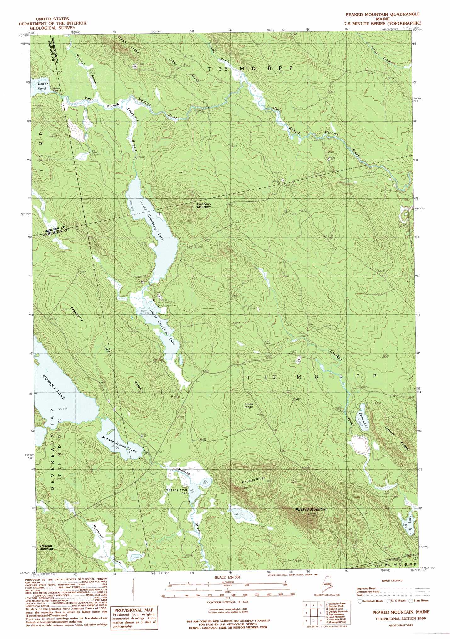
USGS Topo Quad 44067h8 - 1:24,000 scale
| Topo Map Name: | Peaked Mountain |
| USGS Topo Quad ID: | 44067h8 |
| Print Size: | ca. 21 1/4" wide x 27" high |
| Southeast Coordinates: | 44.875° N latitude / 67.875° W longitude |
| Map Center Coordinates: | 44.9375° N latitude / 67.9375° W longitude |
| U.S. State: | ME |
| Filename: | o44067h8.jpg |
| Download Map JPG Image: | Peaked Mountain topo map 1:24,000 scale |
| Map Type: | Topographic |
| Topo Series: | 7.5´ |
| Map Scale: | 1:24,000 |
| Source of Map Images: | United States Geological Survey (USGS) |
| Alternate Map Versions: |
Peaked Mountain ME 1990, updated 1990 Download PDF Buy paper map Peaked Mountain ME 2011 Download PDF Buy paper map Peaked Mountain ME 2014 Download PDF Buy paper map |
1:24,000 Topo Quads surrounding Peaked Mountain
Spring Lake |
Duck Lake |
Dark Cove Mountain |
Grand Lake Stream |
Big Lake |
West Lake |
Gassabias Lake |
Fletcher Peak |
Monroe Lake |
Clifford Lake |
Alligator Lake |
Quillpig Mountain |
Peaked Mountain |
Tug Mountain |
Wesley |
Rocky Pond |
Lead Mountain |
Northeast Bluff |
Montegail Pond |
Peaked Mountain Pond |
Molasses Pond |
Tunk Mountain |
Schoodic Lake |
Epping |
Columbia Falls |
> Back to 44067e1 at 1:100,000 scale
> Back to 44066a1 at 1:250,000 scale
> Back to U.S. Topo Maps home
Peaked Mountain topo map: Gazetteer
Peaked Mountain: Dams
Lower Sabao Lake Dam elevation 106m 347′Mopang Second Lake Dam elevation 101m 331′
Peaked Mountain: Lakes
Lily Lake elevation 73m 239′Lower Cranberry Lake elevation 103m 337′
Mopang First Lake elevation 96m 314′
Mopang Second Lake elevation 101m 331′
Peep Lake elevation 82m 269′
Upper Cranberry Lake elevation 105m 344′
Peaked Mountain: Reservoirs
Lower Pond elevation 106m 347′Peaked Mountain: Ridges
Cranberry Lake Ridge elevation 161m 528′Elwell Ridge elevation 148m 485′
Indian Ridge elevation 114m 374′
Tibbets Ridge elevation 200m 656′
Peaked Mountain: Streams
Cranberry Stream elevation 101m 331′Ingalls Brook elevation 95m 311′
Libby Brook elevation 97m 318′
Rolford Brook elevation 102m 334′
Peaked Mountain: Summits
Cranberry Mountain elevation 187m 613′Peaked Mountain elevation 243m 797′
Peaked Mountain digital topo map on disk
Buy this Peaked Mountain topo map showing relief, roads, GPS coordinates and other geographical features, as a high-resolution digital map file on DVD:
Maine, New Hampshire, Rhode Island & Eastern Massachusetts
Buy digital topo maps: Maine, New Hampshire, Rhode Island & Eastern Massachusetts