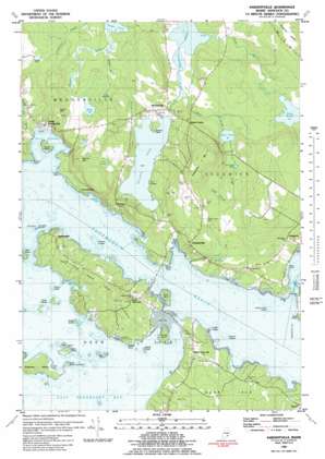
Sargentville Topo Map Maine
To zoom in, hover over the map of Sargentville
USGS Topo Quad 44068c6 - 1:24,000 scale
| Topo Map Name: | Sargentville |
| USGS Topo Quad ID: | 44068c6 |
| Print Size: | ca. 21 1/4" wide x 27" high |
| Southeast Coordinates: | 44.25° N latitude / 68.625° W longitude |
| Map Center Coordinates: | 44.3125° N latitude / 68.6875° W longitude |
| U.S. State: | ME |
| Filename: | o44068c6.jpg |
| Download Map JPG Image: | Sargentville topo map 1:24,000 scale |
| Map Type: | Topographic |
| Topo Series: | 7.5´ |
| Map Scale: | 1:24,000 |
| Source of Map Images: | United States Geological Survey (USGS) |
| Alternate Map Versions: |
Sargentville ME 1981, updated 1982 Download PDF Buy paper map Sargentville ME 1981, updated 1982 Download PDF Buy paper map Sargentville ME 2011 Download PDF Buy paper map Sargentville ME 2014 Download PDF Buy paper map |
1:24,000 Topo Quads surrounding Sargentville
> Back to 44068a1 at 1:100,000 scale
> Back to 44068a1 at 1:250,000 scale
> Back to U.S. Topo Maps home
Sargentville topo map: Gazetteer
Sargentville: Bars
Colossom Ledges elevation 0m 0′Halftide Rock elevation 0m 0′
Harbor Ledge elevation 0m 0′
Howard Ledges elevation 0m 0′
Stump Cove Ledge elevation 0m 0′
Swains Ledge elevation 0m 0′
The Triangles elevation 0m 0′
Tinken Ledges elevation 0m 0′
Weeds Ledge elevation 0m 0′
Sargentville: Bays
Billings Cove elevation 0m 0′Blastow Cove elevation 1m 3′
Bucks Harbor elevation 0m 0′
Deadman Cove elevation 0m 0′
Eastern Cove elevation 0m 0′
Lems Cove elevation 0m 0′
Long Cove elevation 0m 0′
Punch Bowl elevation 0m 0′
Snow Cove elevation 0m 0′
Swains Cove elevation 0m 0′
Thompson Cove elevation 0m 0′
Western Cove elevation 0m 0′
Sargentville: Capes
Byard Point elevation 13m 42′Carter Point elevation 6m 19′
Eastern Point elevation 0m 0′
Grays Point elevation 3m 9′
Joyce Point elevation 7m 22′
Spruce Head elevation 8m 26′
Weeds Point elevation 0m 0′
Sargentville: Channels
Eggemoggin Reach elevation 0m 0′Sargentville: Cliffs
Gull Ledges elevation 7m 22′Sargentville: Dams
Walker Pond Dam elevation 7m 22′Sargentville: Islands
Bar Island elevation 2m 6′Birch Island elevation 6m 19′
Carney Island elevation 10m 32′
Eaton Island elevation 6m 19′
Harbor Island elevation 8m 26′
Little Deer Isle elevation 26m 85′
Little Eaton Island elevation 6m 19′
Little Pickering Island elevation 6m 19′
Pickering Island elevation 5m 16′
Pumpkin Island elevation 5m 16′
Scott Islands elevation 6m 19′
Sheep Island elevation 11m 36′
Stave Island elevation 11m 36′
Sargentville: Lakes
Black Pond elevation 48m 157′Frost Pond elevation 40m 131′
John Gray Pond elevation 50m 164′
Lily Pond elevation 52m 170′
Mill Pond elevation 35m 114′
Parker Pond elevation 20m 65′
Round Pond elevation 56m 183′
Snake Pond elevation 20m 65′
Sargentville: Populated Places
Black Corner elevation 56m 183′Brooksville elevation 8m 26′
Eggemoggin elevation 15m 49′
Herricks elevation 23m 75′
Little Deer Isle elevation 15m 49′
North Deer Isle elevation 26m 85′
Norumbega elevation 6m 19′
Sargentville elevation 37m 121′
South Brooksville elevation 13m 42′
Sargentville: Reservoirs
Walker Pond elevation 7m 22′Sargentville: Ridges
Sedgwick Ridge elevation 103m 337′Sargentville: Streams
Benjamin River elevation 0m 0′Billings Brook elevation 11m 36′
Black Brook elevation 4m 13′
Deep Bridge Brook elevation 52m 170′
Jerrys Brook elevation 23m 75′
Meadow Brook elevation 22m 72′
Snow Brook elevation 3m 9′
Sargentville: Summits
Caterpillar Mountain elevation 148m 485′Kench Mountain elevation 68m 223′
Winche Mountain elevation 92m 301′
Sargentville: Swamps
Jerrys Meadow elevation 24m 78′Sargentville digital topo map on disk
Buy this Sargentville topo map showing relief, roads, GPS coordinates and other geographical features, as a high-resolution digital map file on DVD:
Maine, New Hampshire, Rhode Island & Eastern Massachusetts
Buy digital topo maps: Maine, New Hampshire, Rhode Island & Eastern Massachusetts


