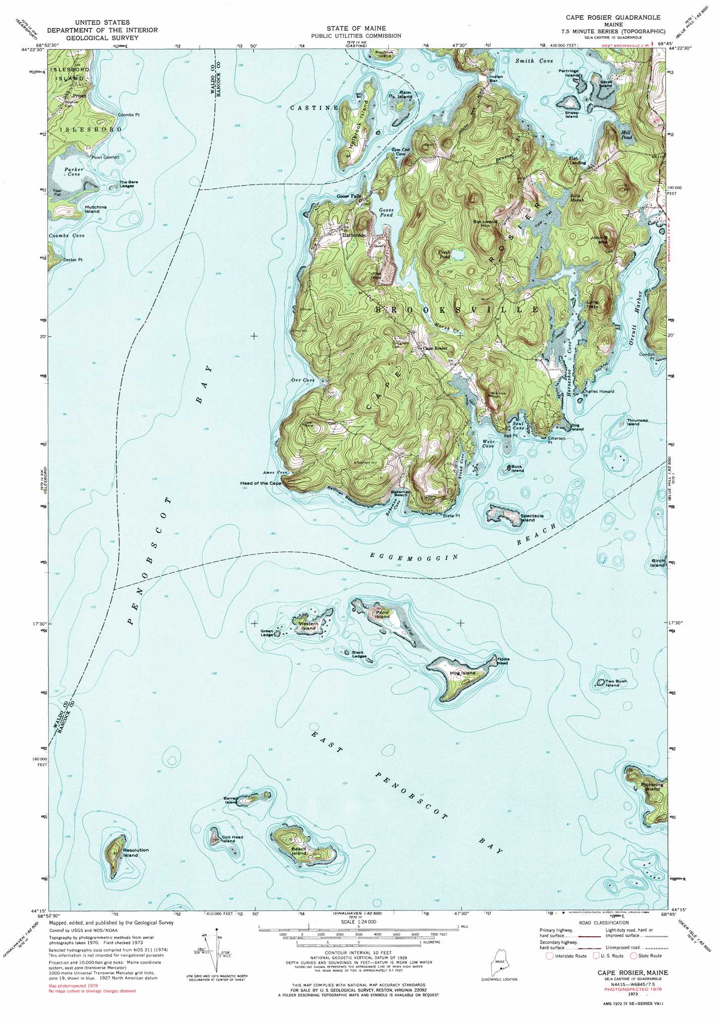
Cape Rosier Topo Map Maine
To zoom in, hover over the map of Cape Rosier
USGS Topo Quad 44068c7 - 1:24,000 scale
| Topo Map Name: | Cape Rosier |
| USGS Topo Quad ID: | 44068c7 |
| Print Size: | ca. 21 1/4" wide x 27" high |
| Southeast Coordinates: | 44.25° N latitude / 68.75° W longitude |
| Map Center Coordinates: | 44.3125° N latitude / 68.8125° W longitude |
| U.S. State: | ME |
| Filename: | o44068c7.jpg |
| Download Map JPG Image: | Cape Rosier topo map 1:24,000 scale |
| Map Type: | Topographic |
| Topo Series: | 7.5´ |
| Map Scale: | 1:24,000 |
| Source of Map Images: | United States Geological Survey (USGS) |
| Alternate Map Versions: |
Cape Rosier ME 1973, updated 1976 Download PDF Buy paper map Cape Rosier ME 1973, updated 1984 Download PDF Buy paper map Cape Rosier ME 1973, updated 1984 Download PDF Buy paper map Cape Rosier ME 2011 Download PDF Buy paper map Cape Rosier ME 2014 Download PDF Buy paper map |
1:24,000 Topo Quads surrounding Cape Rosier
Brooks East |
Mount Waldo |
Bucksport |
Orland |
Branch Lake |
Belfast |
Searsport |
Castine |
Penobscot |
Blue Hill |
Lincolnville |
Islesboro |
Cape Rosier |
Sargentville |
Brooklin |
Camden |
North Haven West |
North Haven East |
Deer Isle |
Stinson Neck |
Rockland |
Leadbetter Island |
Vinalhaven |
Isle Au Haut West |
Isle Au Haut East |
> Back to 44068a1 at 1:100,000 scale
> Back to 44068a1 at 1:250,000 scale
> Back to U.S. Topo Maps home
Cape Rosier topo map: Gazetteer
Cape Rosier: Bars
Black Ledges elevation 0m 0′Indian Bar elevation 0m 0′
Islesboro Ledge elevation 0m 0′
Merriman Ledge elevation 0m 0′
Nautilus Rock elevation 0m 0′
Snyders Rock elevation 0m 0′
Spectacle Island Ledge elevation 0m 0′
The Bare Ledges elevation 1m 3′
Thrumcap Ledge elevation 0m 0′
Two Bush Ledge elevation 0m 0′
Cape Rosier: Bays
Ames Cove elevation 3m 9′Bakeman Cove elevation 0m 0′
Horseshoe Cove elevation 0m 0′
Orr Cove elevation 0m 0′
Parker Cove elevation 0m 0′
Seal Cove elevation 0m 0′
Smith Cove elevation 0m 0′
Stand Cove elevation 0m 0′
Tom Cod Cove elevation 0m 0′
Weir Cove elevation 0m 0′
Cape Rosier: Beaches
Bakeman Beach elevation 2m 6′Redman Beach elevation 0m 0′
Cape Rosier: Capes
Blake Point elevation 4m 13′Cape Rosier elevation 15m 49′
Charles Howard Point elevation 4m 13′
Condon Point elevation 11m 36′
Coombs Point elevation 5m 16′
Decker Point elevation 8m 26′
Emerson Point elevation 3m 9′
Head of the Cape elevation 0m 0′
Point Comfort elevation 5m 16′
Red Point elevation 0m 0′
Cape Rosier: Dams
Goose Pond Dam elevation 3m 9′Cape Rosier: Falls
Goose Falls elevation 3m 9′Cape Rosier: Harbors
Orcutt Harbor elevation 0m 0′Cape Rosier: Islands
Barred Island elevation 7m 22′Beach Island elevation 6m 19′
Buck Island elevation 3m 9′
Colt Head Island elevation 14m 45′
Dog Island elevation 2m 6′
Fiddle Head elevation 4m 13′
Green Ledge elevation 5m 16′
Hog Island elevation 12m 39′
Holbrook Island elevation 7m 22′
Hutchins Island elevation 12m 39′
Nautilus Island elevation 7m 22′
Partridge Island elevation 0m 0′
Pond Island elevation 22m 72′
Ram Island elevation 3m 9′
Resolution Island elevation 26m 85′
Saras Island elevation 8m 26′
Sheep Island elevation 4m 13′
Spectacle Island elevation 7m 22′
Thrumcap Island elevation 7m 22′
Two Bush Island elevation 3m 9′
Western Island elevation 5m 16′
Cape Rosier: Lakes
Fresh Pond elevation 31m 101′Mill Pond elevation 0m 0′
Cape Rosier: Parks
Holbrook Island Sanctuary elevation 16m 52′Cape Rosier: Pillars
Barneys Mistake elevation 0m 0′Cape Rosier: Populated Places
Cape Rosier elevation 14m 45′Flat Landing elevation 12m 39′
Goose Falls elevation 6m 19′
Harborside elevation 26m 85′
Pripet elevation 27m 88′
Cape Rosier: Reservoirs
Goose Pond elevation 3m 9′Cape Rosier: Streams
Benson Brook elevation 4m 13′Marsh Creek elevation 2m 6′
Cape Rosier: Summits
Backwood Mountain elevation 82m 269′John B Mountain elevation 73m 239′
Long Mountain elevation 64m 209′
Cape Rosier: Swamps
Bells Marsh elevation 2m 6′Cape Rosier digital topo map on disk
Buy this Cape Rosier topo map showing relief, roads, GPS coordinates and other geographical features, as a high-resolution digital map file on DVD:
Maine, New Hampshire, Rhode Island & Eastern Massachusetts
Buy digital topo maps: Maine, New Hampshire, Rhode Island & Eastern Massachusetts