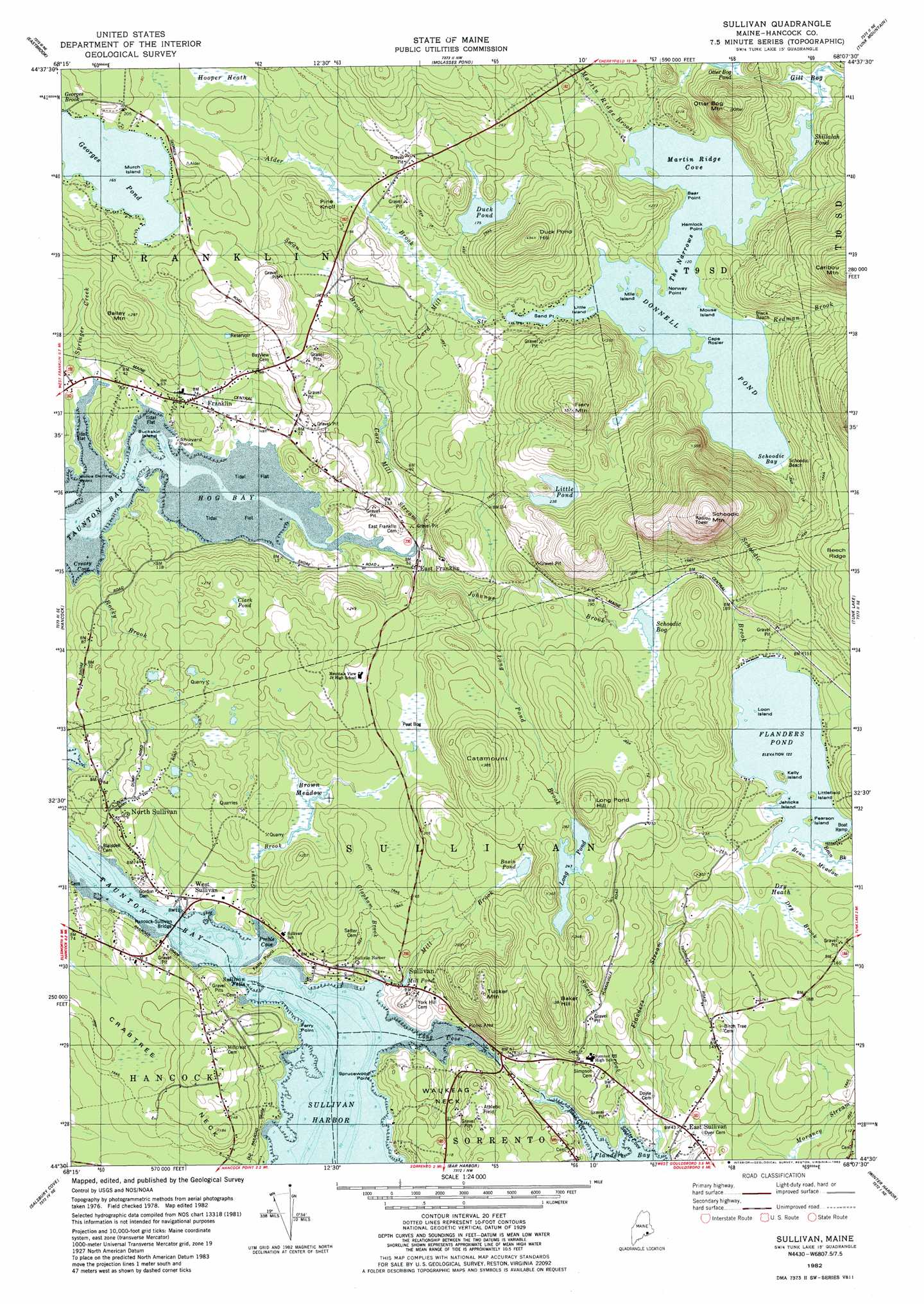
Sullivan Topo Map Maine
To zoom in, hover over the map of Sullivan
USGS Topo Quad 44068e2 - 1:24,000 scale
| Topo Map Name: | Sullivan |
| USGS Topo Quad ID: | 44068e2 |
| Print Size: | ca. 21 1/4" wide x 27" high |
| Southeast Coordinates: | 44.5° N latitude / 68.125° W longitude |
| Map Center Coordinates: | 44.5625° N latitude / 68.1875° W longitude |
| U.S. State: | ME |
| Filename: | o44068e2.jpg |
| Download Map JPG Image: | Sullivan topo map 1:24,000 scale |
| Map Type: | Topographic |
| Topo Series: | 7.5´ |
| Map Scale: | 1:24,000 |
| Source of Map Images: | United States Geological Survey (USGS) |
| Alternate Map Versions: |
Sullivan ME 1982, updated 1983 Download PDF Buy paper map Sullivan ME 1982, updated 1983 Download PDF Buy paper map Sullivan ME 2011 Download PDF Buy paper map Sullivan ME 2014 Download PDF Buy paper map |
1:24,000 Topo Quads surrounding Sullivan
Hopkins Pond |
Amherst |
Rocky Pond |
Lead Mountain |
Northeast Bluff |
Beech Hill Pond |
Eastbrook |
Molasses Pond |
Tunk Mountain |
Schoodic Lake |
Ellsworth |
Hancock |
Sullivan |
Tunk Lake |
Cherryfield |
Newbury Neck |
Salsbury Cove |
Bar Harbor |
Winter Harbor |
Petit Manan Point |
Bartlett Island |
Southwest Harbor |
Seal Harbor |
Schoodic Head |
> Back to 44068e1 at 1:100,000 scale
> Back to 44068a1 at 1:250,000 scale
> Back to U.S. Topo Maps home
Sullivan topo map: Gazetteer
Sullivan: Bays
Creasy Cove elevation 0m 0′Hog Bay elevation 0m 0′
Long Cove elevation 0m 0′
Martin Ridge Cove elevation 36m 118′
Preble Cove elevation 0m 0′
Schoodic Bay elevation 36m 118′
Smelt Cove elevation 1m 3′
Sullivan: Beaches
Black Beach elevation 40m 131′Schoodic Beach elevation 37m 121′
Sullivan: Bridges
Hancock-Sullivan Bridge elevation 0m 0′Sullivan: Capes
Bear Point elevation 42m 137′Cape Rosier elevation 38m 124′
Evergreen Point elevation 12m 39′
Falls Point elevation 4m 13′
Ferry Point elevation 1m 3′
Hemlock Point elevation 36m 118′
Julius Darling Point elevation 2m 6′
Norway Point elevation 36m 118′
Sand Point elevation 44m 144′
Shipyard Point elevation 4m 13′
Sprucewood Point elevation 3m 9′
Sullivan: Channels
The Narrows elevation 36m 118′Sullivan: Dams
Donnell Pond Dam elevation 37m 121′Long Pond Dam elevation 76m 249′
Sullivan: Falls
Sullivan Falls elevation 0m 0′Sullivan: Islands
Buckskin Island elevation 6m 19′Jehlickoo Island elevation 37m 121′
Kelly Island elevation 47m 154′
Little Island elevation 36m 118′
Littlefield Island elevation 38m 124′
Loon Island elevation 37m 121′
Mile Island elevation 42m 137′
Mouse Island elevation 36m 118′
Murch Island elevation 52m 170′
Pearson Island elevation 38m 124′
Sullivan: Lakes
Basin Pond elevation 52m 170′Clark Pond elevation 53m 173′
Duck Pond elevation 53m 173′
Georges Pond elevation 50m 164′
Little Pond elevation 72m 236′
Mill Pond elevation 16m 52′
Shillalah Pond elevation 56m 183′
Sullivan: Populated Places
East Franklin elevation 15m 49′East Sullivan elevation 13m 42′
Franklin elevation 17m 55′
North Sullivan elevation 30m 98′
Schoodic elevation 55m 180′
Sullivan elevation 14m 45′
Waukeag elevation 25m 82′
West Sullivan elevation 8m 26′
Sullivan: Reservoirs
Donnell Pond elevation 37m 121′Flanders Pond elevation 37m 121′
Long Pond elevation 76m 249′
Sullivan: Streams
Alder Brook elevation 31m 101′Card Mill Stream elevation 4m 13′
Clapham Brook elevation 1m 3′
Dry Brook elevation 38m 124′
Flanders Stream elevation 0m 0′
Grays Brook elevation 1m 3′
Johnnys Brook elevation 11m 36′
Long Pond Brook elevation 3m 9′
Martin Ridge Brook elevation 43m 141′
Mill Brook elevation 16m 52′
Redman Brook elevation 36m 118′
Rocky Brook elevation 0m 0′
Schoodic Brook elevation 37m 121′
Smelt Brook elevation 0m 0′
Springer Creek elevation 2m 6′
Swan Brook elevation 38m 124′
Sullivan: Summits
Bailey Mountain elevation 80m 262′Baker Hill elevation 111m 364′
Catamount elevation 117m 383′
Duck Pond Hill elevation 140m 459′
Fiery Mountain elevation 142m 465′
Long Pond Hill elevation 126m 413′
Otter Bog Mountain elevation 98m 321′
Pine Knoll elevation 57m 187′
Schoodic Mountain elevation 319m 1046′
Schoodic Nubble elevation 202m 662′
Tucker Mountain elevation 110m 360′
Sullivan: Swamps
Bean Meadow elevation 39m 127′Brown Meadow elevation 34m 111′
Dry Heath elevation 38m 124′
Gill Bog elevation 56m 183′
Schoodic Bog elevation 58m 190′
Sullivan digital topo map on disk
Buy this Sullivan topo map showing relief, roads, GPS coordinates and other geographical features, as a high-resolution digital map file on DVD:
Maine, New Hampshire, Rhode Island & Eastern Massachusetts
Buy digital topo maps: Maine, New Hampshire, Rhode Island & Eastern Massachusetts