Orland Topo Map Maine
To zoom in, hover over the map of Orland
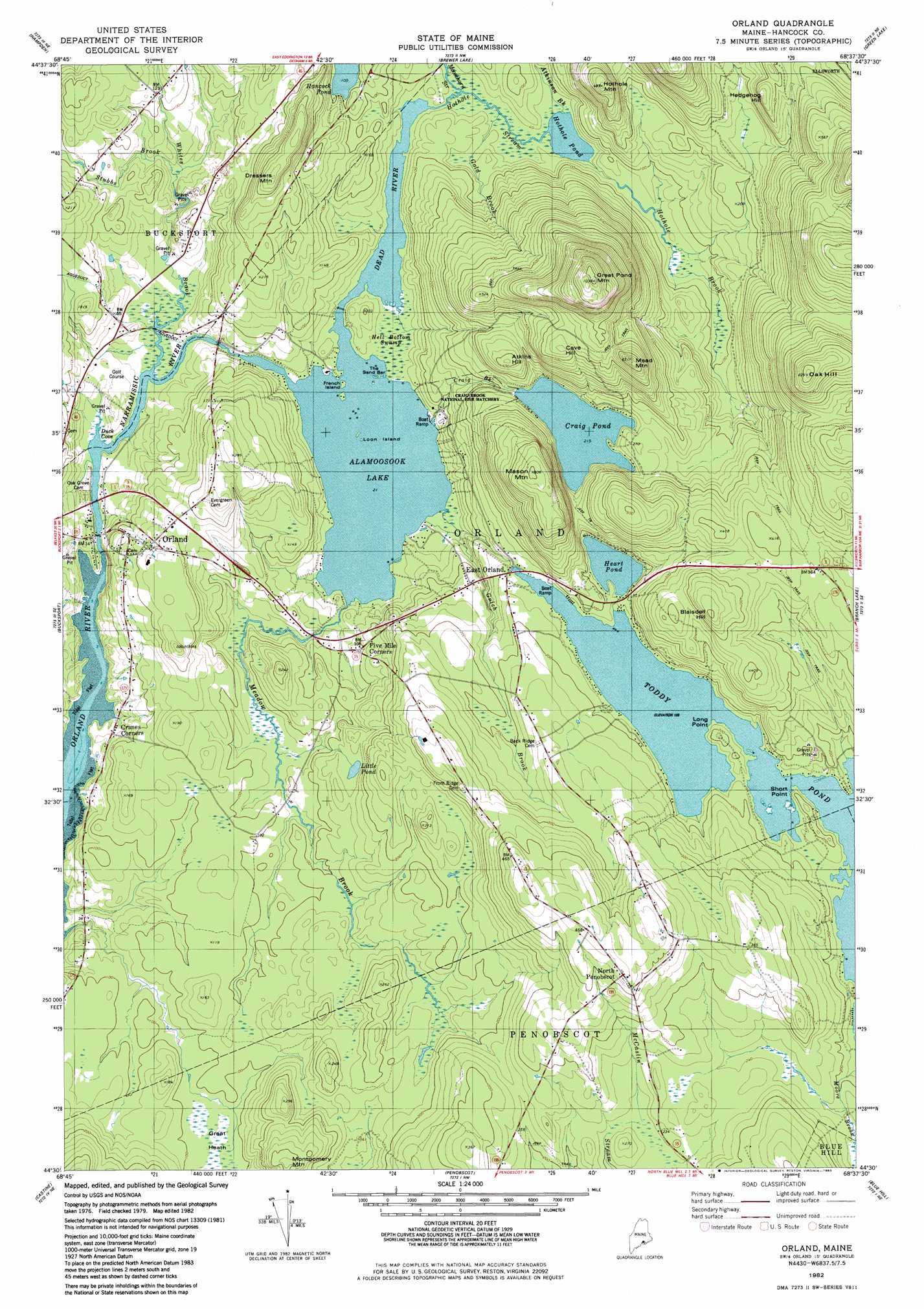
USGS Topo Quad 44068e6 - 1:24,000 scale
| Topo Map Name: | Orland |
| USGS Topo Quad ID: | 44068e6 |
| Print Size: | ca. 21 1/4" wide x 27" high |
| Southeast Coordinates: | 44.5° N latitude / 68.625° W longitude |
| Map Center Coordinates: | 44.5625° N latitude / 68.6875° W longitude |
| U.S. State: | ME |
| Filename: | o44068e6.jpg |
| Download Map JPG Image: | Orland topo map 1:24,000 scale |
| Map Type: | Topographic |
| Topo Series: | 7.5´ |
| Map Scale: | 1:24,000 |
| Source of Map Images: | United States Geological Survey (USGS) |
| Alternate Map Versions: |
Orland ME 1982, updated 1983 Download PDF Buy paper map Orland ME 2011 Download PDF Buy paper map Orland ME 2014 Download PDF Buy paper map |
1:24,000 Topo Quads surrounding Orland
Hermon |
Bangor |
Veazie |
Chemo Pond |
Hopkins Pond |
Snow Mountain |
Hampden |
Brewer Lake |
Green Lake |
Beech Hill Pond |
Mount Waldo |
Bucksport |
Orland |
Branch Lake |
Ellsworth |
Searsport |
Castine |
Penobscot |
Blue Hill |
Newbury Neck |
Islesboro |
Cape Rosier |
Sargentville |
Brooklin |
Bartlett Island |
> Back to 44068e1 at 1:100,000 scale
> Back to 44068a1 at 1:250,000 scale
> Back to U.S. Topo Maps home
Orland topo map: Gazetteer
Orland: Bars
The Sand Bar elevation 6m 19′Orland: Bays
Duck Cove elevation 4m 13′Orland: Capes
Long Point elevation 63m 206′Short Point elevation 50m 164′
Orland: Dams
Alamoosook Dam elevation 6m 19′Craig Pond Dam elevation 66m 216′
Orland Village Dam elevation 2m 6′
Toddy Pond Dam elevation 49m 160′
Orland: Islands
French Island elevation 6m 19′Loon Island elevation 6m 19′
Orland: Lakes
Hancock Pond elevation 30m 98′Heart Pond elevation 50m 164′
Hothole Pond elevation 9m 29′
Little Pond elevation 39m 127′
Orland: Mines
Annear Copper Mine elevation 70m 229′Orland: Populated Places
Cranes Corners elevation 16m 52′East Orland elevation 49m 160′
Five Mile Corners elevation 30m 98′
North Penobscot elevation 133m 436′
Orland elevation 60m 196′
Orland: Reservoirs
Alamoosook Lake elevation 6m 19′Craig Pond elevation 66m 216′
Main Stem Orland River Reservoir elevation 2m 6′
Toddy Pond elevation 49m 160′
Orland: Streams
Atkinson Brook elevation 9m 29′Craig Pond Brook elevation 6m 19′
Dead River elevation 6m 19′
Gold Brook elevation 12m 39′
Gulch Brook elevation 6m 19′
Hothole Brook elevation 12m 39′
Hothole Brook elevation 9m 29′
Meadow Brook elevation 8m 26′
Moosehorn Stream elevation 10m 32′
Mountain Brook elevation 8m 26′
Narramissic River elevation 3m 9′
Stubbs Brook elevation 9m 29′
Whites Brook elevation 4m 13′
Orland: Summits
Atkins Hill elevation 128m 419′Blaisdell Hill elevation 134m 439′
Cave Hill elevation 162m 531′
Condon Hill elevation 183m 600′
Dressers Mountain elevation 105m 344′
Flying Moose Mountain elevation 245m 803′
Great Pond Mountain elevation 291m 954′
Hedgehog Hill elevation 93m 305′
Hothole Mountain elevation 98m 321′
Mason Mountain elevation 183m 600′
Mead Mountain elevation 163m 534′
Montgomery Mountain elevation 96m 314′
Patton Hill elevation 109m 357′
Orland: Swamps
Great Heath elevation 29m 95′Hell Bottom Swamp elevation 8m 26′
Orland digital topo map on disk
Buy this Orland topo map showing relief, roads, GPS coordinates and other geographical features, as a high-resolution digital map file on DVD:
Maine, New Hampshire, Rhode Island & Eastern Massachusetts
Buy digital topo maps: Maine, New Hampshire, Rhode Island & Eastern Massachusetts