Hampden Topo Map Maine
To zoom in, hover over the map of Hampden
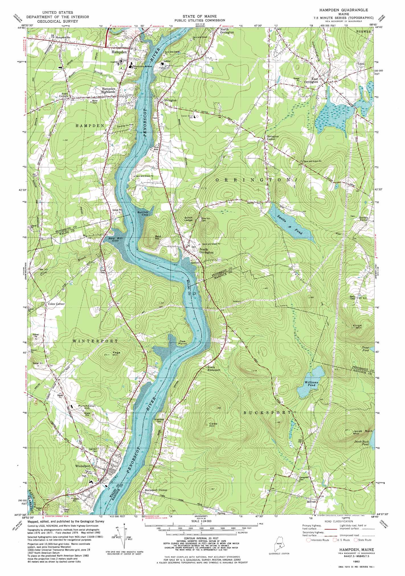
USGS Topo Quad 44068f7 - 1:24,000 scale
| Topo Map Name: | Hampden |
| USGS Topo Quad ID: | 44068f7 |
| Print Size: | ca. 21 1/4" wide x 27" high |
| Southeast Coordinates: | 44.625° N latitude / 68.75° W longitude |
| Map Center Coordinates: | 44.6875° N latitude / 68.8125° W longitude |
| U.S. State: | ME |
| Filename: | o44068f7.jpg |
| Download Map JPG Image: | Hampden topo map 1:24,000 scale |
| Map Type: | Topographic |
| Topo Series: | 7.5´ |
| Map Scale: | 1:24,000 |
| Source of Map Images: | United States Geological Survey (USGS) |
| Alternate Map Versions: |
Hampden ME 1982, updated 1982 Download PDF Buy paper map Hampden ME 2011 Download PDF Buy paper map Hampden ME 2014 Download PDF Buy paper map |
1:24,000 Topo Quads surrounding Hampden
West Corinth |
Kenduskeag |
Pushaw Lake |
Old Town |
Otter Chain Ponds |
Carmel |
Hermon |
Bangor |
Veazie |
Chemo Pond |
East Dixmont |
Snow Mountain |
Hampden |
Brewer Lake |
Green Lake |
Brooks East |
Mount Waldo |
Bucksport |
Orland |
Branch Lake |
Belfast |
Searsport |
Castine |
Penobscot |
Blue Hill |
> Back to 44068e1 at 1:100,000 scale
> Back to 44068a1 at 1:250,000 scale
> Back to U.S. Topo Maps home
Hampden topo map: Gazetteer
Hampden: Bays
Bald Hill Cove elevation 2m 6′Bartlett Cove elevation 2m 6′
Hampden: Benches
Smith Ledge elevation 47m 154′Hampden: Capes
Coles Corner elevation 65m 213′Oak Point elevation 22m 72′
Snub Point elevation 7m 22′
Hampden: Channels
Bald Hill Reach elevation 2m 6′Hampden: Dams
East Orrington Dam elevation 33m 108′Souadabscook Dam elevation 6m 19′
Hampden: Lakes
Fields Pond elevation 33m 108′Williams Pond elevation 82m 269′
Hampden: Parks
Creative Playground elevation 50m 164′Dorothea Dix Park elevation 33m 108′
Hampden: Populated Places
Arey elevation 58m 190′Bucksport Center elevation 42m 137′
East Orrington elevation 33m 108′
Goodale Corner elevation 113m 370′
Hampden elevation 33m 108′
Hampden Highlands elevation 49m 160′
Hampden Station elevation 45m 147′
Millvale elevation 36m 118′
North Bucksport elevation 63m 206′
North Orrington elevation 55m 180′
North Winterport elevation 63m 206′
Orrington elevation 40m 131′
Orrington Center elevation 38m 124′
South Orrington elevation 17m 55′
Winterport elevation 21m 68′
Hampden: Reservoirs
Souadabscook Stream Reservoir elevation 6m 19′Swetts Pond elevation 60m 196′
Hampden: Streams
Cove Brook elevation 38m 124′Mill Creek elevation 6m 19′
Reeds Brook elevation 2m 6′
Souadabscook Stream elevation 2m 6′
Hampden: Summits
Bald Hill elevation 77m 252′Cobb Hill elevation 172m 564′
Jacob Buck Mountain elevation 215m 705′
Kings Mountain elevation 256m 839′
Page Hill elevation 114m 374′
Punchbowl Hill elevation 75m 246′
Hampden digital topo map on disk
Buy this Hampden topo map showing relief, roads, GPS coordinates and other geographical features, as a high-resolution digital map file on DVD:
Maine, New Hampshire, Rhode Island & Eastern Massachusetts
Buy digital topo maps: Maine, New Hampshire, Rhode Island & Eastern Massachusetts