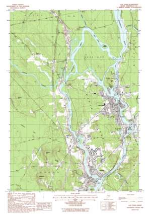
Old Town Topo Map Maine
To zoom in, hover over the map of Old Town
USGS Topo Quad 44068h6 - 1:24,000 scale
| Topo Map Name: | Old Town |
| USGS Topo Quad ID: | 44068h6 |
| Print Size: | ca. 21 1/4" wide x 27" high |
| Southeast Coordinates: | 44.875° N latitude / 68.625° W longitude |
| Map Center Coordinates: | 44.9375° N latitude / 68.6875° W longitude |
| U.S. State: | ME |
| Filename: | o44068h6.jpg |
| Download Map JPG Image: | Old Town topo map 1:24,000 scale |
| Map Type: | Topographic |
| Topo Series: | 7.5´ |
| Map Scale: | 1:24,000 |
| Source of Map Images: | United States Geological Survey (USGS) |
| Alternate Map Versions: |
Old Town ME 1988, updated 1988 Download PDF Buy paper map Old Town ME 1988, updated 1988 Download PDF Buy paper map Old Town ME 1998, updated 2001 Download PDF Buy paper map Old Town ME 2011 Download PDF Buy paper map Old Town ME 2014 Download PDF Buy paper map |
1:24,000 Topo Quads surrounding Old Town
> Back to 44068e1 at 1:100,000 scale
> Back to 44068a1 at 1:250,000 scale
> Back to U.S. Topo Maps home
Old Town topo map: Gazetteer
Old Town: Airports
Dewitt Field elevation 38m 124′Old Town: Crossings
Interchange 51 elevation 42m 137′Interchange 52 elevation 42m 137′
Interchange 53 elevation 39m 127′
Old Town: Dams
Blackman Stream Dam Number 1 elevation 23m 75′Great Works Dam elevation 25m 82′
Milford Dam elevation 31m 101′
Orono Dam elevation 16m 52′
Stillwater Dam elevation 29m 95′
Old Town: Forests
University Forest elevation 42m 137′Old Town: Islands
Ayers Island elevation 15m 49′Black Island elevation 31m 101′
Boom Islands elevation 31m 101′
Indian Island elevation 36m 118′
Marsh Island elevation 46m 150′
Orono Island elevation 33m 108′
Orson Island elevation 40m 131′
Socks Island elevation 32m 104′
Twin Islands elevation 32m 104′
Old Town: Parks
Alumni Stadium elevation 34m 111′Binette Park elevation 29m 95′
Chester G Bridges Tennis Complex elevation 35m 114′
Clarence B Beckett Family Track and Field Complex elevation 34m 111′
Concert Park elevation 39m 127′
Mahoney Diamond elevation 35m 114′
Marden Park elevation 31m 101′
North Athletic Fields elevation 35m 114′
Old Town Park elevation 33m 108′
Orono Main Street Historic District elevation 42m 137′
Spencer Park elevation 37m 121′
University of Maine at Orono Historic District elevation 30m 98′
Webster Park elevation 24m 78′
Old Town: Populated Places
Bradley elevation 26m 85′French Settlement elevation 51m 167′
Great Works elevation 36m 118′
Milford elevation 41m 134′
Old Town elevation 33m 108′
Orono elevation 38m 124′
Pea Cove elevation 48m 157′
Pushaw elevation 45m 147′
Stillwater elevation 40m 131′
Webster elevation 30m 98′
Old Town: Post Offices
Old Town Post Office elevation 35m 114′Old Town: Reservoirs
Blackman Stream elevation 23m 75′Penobscot River Reservoir elevation 31m 101′
Penobscot River Reservoir elevation 25m 82′
Stillwater River Reservoir elevation 29m 95′
Stillwater River Reservoir elevation 16m 52′
Old Town: Streams
Birch Stream elevation 32m 104′Blackman Stream elevation 17m 55′
Great Works Stream elevation 24m 78′
Oliver Brook elevation 25m 82′
Otter Stream elevation 24m 78′
Pushaw Stream elevation 31m 101′
Stillwater River elevation 13m 42′
Sunkhaze Stream elevation 32m 104′
Old Town: Summits
Bangor Hill elevation 82m 269′Fairdale Hill elevation 70m 229′
Kelley Hill elevation 102m 334′
Newman Hill elevation 82m 269′
Oak Hill elevation 49m 160′
Old Town digital topo map on disk
Buy this Old Town topo map showing relief, roads, GPS coordinates and other geographical features, as a high-resolution digital map file on DVD:
Maine, New Hampshire, Rhode Island & Eastern Massachusetts
Buy digital topo maps: Maine, New Hampshire, Rhode Island & Eastern Massachusetts


