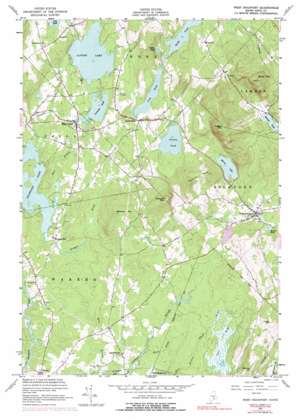
West Rockport Topo Map Maine
To zoom in, hover over the map of West Rockport
USGS Topo Quad 44069b2 - 1:24,000 scale
| Topo Map Name: | West Rockport |
| USGS Topo Quad ID: | 44069b2 |
| Print Size: | ca. 21 1/4" wide x 27" high |
| Southeast Coordinates: | 44.125° N latitude / 69.125° W longitude |
| Map Center Coordinates: | 44.1875° N latitude / 69.1875° W longitude |
| U.S. State: | ME |
| Filename: | o44069b2.jpg |
| Download Map JPG Image: | West Rockport topo map 1:24,000 scale |
| Map Type: | Topographic |
| Topo Series: | 7.5´ |
| Map Scale: | 1:24,000 |
| Source of Map Images: | United States Geological Survey (USGS) |
| Alternate Map Versions: |
West Rockport ME 1955, updated 1959 Download PDF Buy paper map West Rockport ME 1955, updated 1967 Download PDF Buy paper map West Rockport ME 1955, updated 1974 Download PDF Buy paper map West Rockport ME 1955, updated 1978 Download PDF Buy paper map West Rockport ME 1955, updated 1991 Download PDF Buy paper map West Rockport ME 2011 Download PDF Buy paper map West Rockport ME 2014 Download PDF Buy paper map |
1:24,000 Topo Quads surrounding West Rockport
> Back to 44069a1 at 1:100,000 scale
> Back to 44068a1 at 1:250,000 scale
> Back to U.S. Topo Maps home
West Rockport topo map: Gazetteer
West Rockport: Dams
Alford Lake Dam elevation 81m 265′East Union Dam elevation 81m 265′
Fish Pond Dam elevation 106m 347′
Mirror Lake Dam elevation 114m 374′
Tolman Dam elevation 54m 177′
West Rockport: Lakes
Cotton Pond elevation 132m 433′Crawford Pond elevation 33m 108′
Grassy Pond elevation 98m 321′
Hobbs Pond elevation 108m 354′
Hosmer Pond elevation 64m 209′
Lermond Pond elevation 81m 265′
Lily Pond elevation 137m 449′
Rocky Pond elevation 75m 246′
West Rockport: Parks
Meadow Mountain Preserve elevation 72m 236′West Rockport: Populated Places
East Union elevation 86m 282′East Warren elevation 65m 213′
South Hope elevation 116m 380′
Wattons Mill elevation 44m 144′
West Rockport elevation 67m 219′
West Rockport: Reservoirs
Alford Lake elevation 81m 265′Fish Pond elevation 106m 347′
Lerman Pond elevation 81m 265′
Mirror Lake elevation 114m 374′
Tolman Pond elevation 54m 177′
West Rockport: Streams
Keene Brook elevation 29m 95′Mill Stream elevation 33m 108′
Quiggle Brook elevation 33m 108′
West Branch Oyster River elevation 32m 104′
West Rockport: Summits
Bald Mountain elevation 384m 1259′Benner Hill elevation 188m 616′
Dodge Mountain elevation 201m 659′
Gurney Hill elevation 171m 561′
Meadow Mountain elevation 187m 613′
Pleasant Mountain elevation 313m 1026′
Ragged Mountain elevation 390m 1279′
Spruce Mountain elevation 291m 954′
West Rockport: Swamps
The Bog elevation 54m 177′West Rockport: Trails
Ragged Mountain Trail elevation 70m 229′West Rockport digital topo map on disk
Buy this West Rockport topo map showing relief, roads, GPS coordinates and other geographical features, as a high-resolution digital map file on DVD:
Maine, New Hampshire, Rhode Island & Eastern Massachusetts
Buy digital topo maps: Maine, New Hampshire, Rhode Island & Eastern Massachusetts


