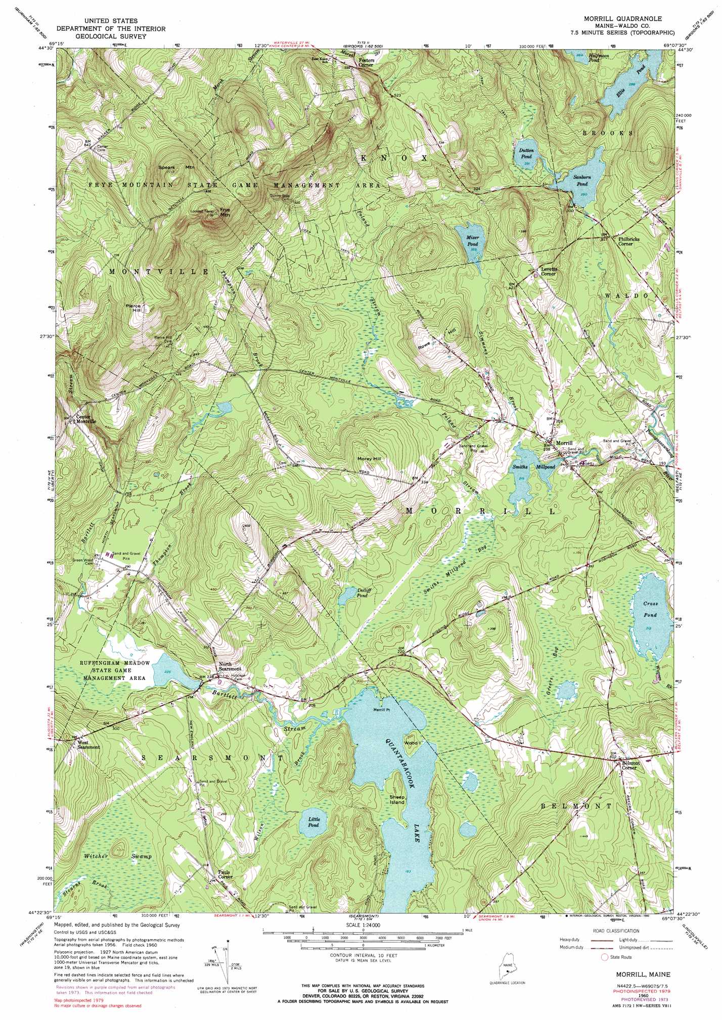
Morrill Topo Map Maine
To zoom in, hover over the map of Morrill
USGS Topo Quad 44069d2 - 1:24,000 scale
| Topo Map Name: | Morrill |
| USGS Topo Quad ID: | 44069d2 |
| Print Size: | ca. 21 1/4" wide x 27" high |
| Southeast Coordinates: | 44.375° N latitude / 69.125° W longitude |
| Map Center Coordinates: | 44.4375° N latitude / 69.1875° W longitude |
| U.S. State: | ME |
| Filename: | o44069d2.jpg |
| Download Map JPG Image: | Morrill topo map 1:24,000 scale |
| Map Type: | Topographic |
| Topo Series: | 7.5´ |
| Map Scale: | 1:24,000 |
| Source of Map Images: | United States Geological Survey (USGS) |
| Alternate Map Versions: |
Morrill ME 1960, updated 1962 Download PDF Buy paper map Morrill ME 1960, updated 1974 Download PDF Buy paper map Morrill ME 1960, updated 1985 Download PDF Buy paper map Morrill ME 1960, updated 1990 Download PDF Buy paper map Morrill ME 2011 Download PDF Buy paper map Morrill ME 2014 Download PDF Buy paper map |
1:24,000 Topo Quads surrounding Morrill
Burnham |
Unity Pond |
Dixmont |
East Dixmont |
Snow Mountain |
Albion |
Unity |
Brooks West |
Brooks East |
Mount Waldo |
Palermo |
Liberty |
Morrill |
Belfast |
Searsport |
Razorville |
Washington |
Searsmont |
Lincolnville |
Islesboro |
Jefferson |
Union |
West Rockport |
Camden |
North Haven West |
> Back to 44069a1 at 1:100,000 scale
> Back to 44068a1 at 1:250,000 scale
> Back to U.S. Topo Maps home
Morrill topo map: Gazetteer
Morrill: Capes
Merrill Point elevation 56m 183′Morrill: Dams
Ellis Pond Dam elevation 91m 298′Sanborn Pond Dam elevation 88m 288′
Smiths Millpond Dam elevation 66m 216′
Morrill: Islands
Sheep Island elevation 62m 203′Wood Island elevation 56m 183′
Morrill: Lakes
Cross Pond elevation 65m 213′Dolliff Pond elevation 68m 223′
Dutton Pond elevation 88m 288′
Little Pond elevation 62m 203′
Mixer Pond elevation 112m 367′
Morrill: Parks
Frye Mountain State Game Management Area elevation 277m 908′Ruffingham Meadow State Game Management Area elevation 69m 226′
Morrill: Populated Places
Belmont Corner elevation 122m 400′Center Montville elevation 151m 495′
Fosters Corner elevation 168m 551′
Morrill elevation 73m 239′
North Searsmont elevation 71m 232′
Pauls Corner elevation 89m 291′
West Searsmont elevation 125m 410′
Morrill: Reservoirs
Ellis Pond elevation 91m 298′Sanborn Pond elevation 88m 288′
Smiths Millpond elevation 66m 216′
Morrill: Streams
Bartlett Stream elevation 139m 456′Poland Stream elevation 66m 216′
Simmons Brook elevation 66m 216′
Thompson Brook elevation 70m 229′
Wilson Brook elevation 56m 183′
Morrill: Summits
Frye Mountain elevation 342m 1122′Morey Hill elevation 152m 498′
Pierce Hill elevation 262m 859′
Rowe Hill elevation 160m 524′
Spears Mountain elevation 336m 1102′
Morrill: Swamps
Greers Bog elevation 66m 216′Smiths Millpond Bog elevation 63m 206′
Witcher Swamp elevation 85m 278′
Morrill digital topo map on disk
Buy this Morrill topo map showing relief, roads, GPS coordinates and other geographical features, as a high-resolution digital map file on DVD:
Maine, New Hampshire, Rhode Island & Eastern Massachusetts
Buy digital topo maps: Maine, New Hampshire, Rhode Island & Eastern Massachusetts